Harbor Springs, Michigan

Last updated

Harbor Springs, Michigan
City of Harbor Springs
Harbor Springs Michigan Downtown Looking East M-119.jpg
Downtown Harbor Springs along M-119
Harbor Springs, MI location2.png
Location within Emmet County
USA Michigan location map.svg
Red pog.svg
Harbor Springs
Location within the state of Michigan
Coordinates: 45°25′54″N84°59′31″W / 45.43167°N 84.99194°W / 45.43167; -84.99194
Country United States
State Michigan
County Emmet
Incorporated1880
Government
  Type Mayor–council
   Mayor Matthew Bugera
   Manager Victor Sinadinoski
Area
[1]
  Total1.30 sq mi (3.37 km2)
  Land1.30 sq mi (3.37 km2)
  Water0.00 sq mi (0.00 km2)
Elevation
[2]
669 ft (204 m)
Population
 (2020)
  Total1,274
  Density977.74/sq mi (377.57/km2)
Time zone UTC-5 (EST)
  Summer (DST) UTC-4 (EDT)
ZIP code(s)
49740
Area code 231
FIPS code 26-36560 [3]
GNIS feature ID0627758 [2]
Website Official website

Harbor Springs is a city and resort community in Emmet County, Michigan, United States. The population was 1,274 in the 2020 census. [4]

Contents

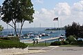
Harbor Springs is in a sheltered bay on the north shore of the Little Traverse Bay on Lake Michigan. The Little Traverse Lighthouse is a historic lighthouse on the Harbor Point peninsula, which shelters the deepest natural harbor on the Great Lakes. M-119 connects with US 31 7 miles (11 km) east and south at Bay View and Petoskey, which is 4 miles (6.4 km) away on the south side of the harbor.

The area is known for its historic summer resorts, such as Wequetonsing, which was founded by Illinois businessmen and lawyers Henry Stryker III, and Henry Brigham McClure. They were both connected with the Jacob Bunn industrial dynasty of Illinois.

History

Bay Street in Harbor Springs, circa 1900s Bay Street (NBY 5160).jpg
Bay Street in Harbor Springs, circa 1900s

The European-American settlement started with a mission by French Catholic Jesuits; they called this area L'Arbre Croche, meaning Crooked Tree. In 1847, L'Arbre Croche had the largest concentration of Native Americans in Michigan. [5] French traders renamed the area Petit Traverse, or Little Crossing, when they arrived in the area. After more settlers came from the eastern United States, they changed the name of the village to Harbor Springs, incorporating it in 1880.

The federally recognized Little Traverse Bay Bands of Odawa Indians are descendants of the numerous Odawa bands that occupied this area. They have their tribal offices in Harbor Springs and a gaming resort in Petoskey.

Ephraim Shay's hexagonally shaped house. 2009-0619-HarborSprings-Hex.JPG
Ephraim Shay's hexagonally shaped house.

Ephraim Shay (1839–1916) is known for his invention of the Shay locomotive. The hexagonal-shaped house he built in downtown Harbor Springs is listed on the National Register of Historic Places. The local elementary school is named after him. [6]

The Douglas House on the shore of Lake Michigan was designed by architect Richard Meier and completed in 1973. This house is one of 150 structures listed in 2007 as America's Favorite Architecture by the American Institute of Architects. [7]

The Club Ponytail was a music hall destroyed by fire in 1969.

Geography

According to the United States Census Bureau, the city has a total area of 1.30 square miles (3.37 km2), all of it land. [8]

Climate

The climate is described as Humid Continental by the Köppen Climate System, abbreviated as Dfb. [9]

Demographics

Historical population
CensusPop.Note
1880 164
1890 1,052541.5%
1900 1,64356.2%
1910 1,8059.9%
1920 1,600−11.4%
1930 1,429−10.7%
1940 1,423−0.4%
1950 1,62614.3%
1960 1,433−11.9%
1970 1,66216.0%
1980 1,567−5.7%
1990 1,540−1.7%
2000 1,5671.8%
2010 1,194−23.8%
2020 1,2746.7%
U.S. Decennial Census [10]

2010 census

As of the census [11] of 2010, there were 1,194 people, 558 households, and 294 families residing in the city. The population density was 918.5 inhabitants per square mile (354.6/km2). There were 1,122 housing units at an average density of 863.1 per square mile (333.2/km2). The racial makeup of the city was 92.0% white, 0.3% African American, 4.8% Native American, 0.8% Asian, 0.1% Pacific Islander, 0.1% from other races, and 2.0% from two or more races. Hispanic or Latino of any race were 0.7% of the population.

There were 558 households, of which 19.4% included children under the age of 18, 38.4% were married couples living together, 10.0% had a female householder with no husband present, 4.3% had a male householder with no wife present, and 47.3% were non-families. 43.7% of all households were made up of individuals, and 23.1% had someone living alone who was 65 years of age or older. The average household size was 1.93 and the average family size was 2.66.

The median age in the city was 55.8 years. 15.7% of residents were under the age of 18; 4.9% were between the ages of 18 and 24; 14.7% were from 25 to 44; 32.6% were from 45 to 64; and 32.2% were 65 years of age or older. The gender makeup of the city was 43.8% male and 56.2% female.

2000 census

Largest ancestries (2000)Percent
German Flag of Germany.svg 17.4%
English Flag of England.svg 16.2%
Irish Flag of Ireland.svg 14.1%
French Flag of France.svg Drapeau Franco-Americain.svg7.4%
Polish Flag of Poland.svg 6.7%
American Flag of the United States.svg 6.2%
Odawa Anishinabe.png4.34%

As of the census [3] of 2000, there were 1,567 people, 683 households, and 383 families residing in the city. The population density was 1,208.9 inhabitants per square mile (466.8/km2). There were 1,086 housing units at an average density of 837.8 per square mile (323.5/km2). The racial makeup of the city was 91.70% White, 0.19% African American, 5.87% Native American, 0.19% Asian, and 2.04% from two or more races. Hispanic or Latino of any race were 0.57% of the population.

There were 683 households, out of which 23.0% had children under the age of 18 living with them, 46.0% were married couples living together, 7.8% had a female householder with no husband present, and 43.8% were non-families. 39.4% of all households were made up of individuals, and 18.0% had someone living alone who was 65 years of age or older. The average household size was 2.14 and the average family size was 2.88.

City Hall 2009-0619-HarborSprings-CityHall.JPG
City Hall

In the city, the population was spread out, with 20.4% under the age of 18, 4.6% from 18 to 24, 22.8% from 25 to 44, 28.3% from 45 to 64, and 23.8% who were 65 years of age or older. The median age was 47 years. For every 100 females, there were 81.6 males. For every 100 females age 18 and over, there were 74.4 males.

The median income for a household in the city was $35,341, and the median income for a family was $46,750. Males had a median income of $29,236 versus $27,167 for females. The per capita income for the city was $21,876. About 5.3% of families and 6.8% of the population were below the poverty line, including 6.5% of those under age 18 and 9.8% of those age 65 or over.

Transportation

Airports

Panorama from the bluff overlooking the city Harbor 002.jpg
Panorama from the bluff overlooking the city

Highways

Notable people

Images

Related Research Articles

<span class="mw-page-title-main">Emmet County, Michigan</span> County in Michigan, United States

Emmet County is a county located in the U.S. state of Michigan. It is the northernmost county in the Lower Peninsula. As of the 2020 Census, the population was 34,112, making it the second-most populous county in Northern Michigan. The county seat is Petoskey, which is also the county's largest city.

<span class="mw-page-title-main">Cheboygan County, Michigan</span> County in Michigan, United States

Cheboygan County is a county in the U.S. state of Michigan. As of the 2020 Census, the population was 25,579. The county seat is Cheboygan. The county boundaries were set off in 1840, with land partitioned from Michilimackinac County. The Cheboygan County government was organized and combined with the former Wyandot County in 1853.

<span class="mw-page-title-main">Charlevoix County, Michigan</span> County in Michigan, United States

Charlevoix County is a county in the U.S. state of Michigan. The county seat is Charlevoix, and the largest city is Boyne City. Located in the Northern Lower Peninsula, Charlevoix County is bisected by Lake Charlevoix, Michigan's third largest inland lake. As of the 2020 Census, the county's population was 26,054.

<span class="mw-page-title-main">Torch Lake Township, Antrim County, Michigan</span> Civil township in Michigan, United States

Torch Lake Township is a civil township of Antrim County in the U.S. state of Michigan. Located in the Northern Lower Peninsula, the township comprises an isthmus between the eponymous Torch Lake and Grand Traverse Bay, a bay of Lake Michigan. As of the 2020 census, the township population was 1,212, a slight increase from 1,194 at the 2010 census.

<span class="mw-page-title-main">Bear Creek Township, Michigan</span> Civil township in Michigan, United States

Bear Creek Township is a civil township of Emmet County in the U.S. state of Michigan. As of the 2020 census, the township population was 6,542, making it the most populous municipality in Emmet County.

<span class="mw-page-title-main">McKinley Township, Emmet County, Michigan</span> Civil township in Michigan, United States

McKinley Township is a civil township of Emmet County in the U.S. state of Michigan. The population was 1,297 at the 2010 census. McKinley Township is home to Pellston Regional Airport.

<span class="mw-page-title-main">Pellston, Michigan</span> Village in Michigan, United States

Pellston is a village in Emmet County in the U.S. state of Michigan. The population was 822 at the 2010 census. The village is the home of Pellston Regional Airport.

<span class="mw-page-title-main">Petoskey, Michigan</span> City in Michigan, United States

Petoskey is a city in the U.S. state of Michigan. It is the county seat of Emmet County, and is the largest settlement within the county. Petoskey has a population of 5,877 at the 2020 census, up from 5,670 at the 2010 census.

<span class="mw-page-title-main">Resort Township, Michigan</span> Civil township in Michigan, United States

Resort Township is a civil township of Emmet County in the U.S. state of Michigan. The southwesternmost township of Emmet County, Resort Township is immediately adjacent Petoskey, the county seat and largest city in Emmet County. Resort Township also has a shoreline on Little Traverse Bay, a bay of Lake Michigan. At the 2020 census, the population was 2,835, an increase from 2,697 at the 2010 census.

<span class="mw-page-title-main">Fife Lake, Michigan</span> Village in Michigan, United States

Fife Lake is a village in southeastern Grand Traverse County in the U.S. state of Michigan. Its population was 456 at the 2020 census, up from 443 at the 2010 census. The village is part of the Traverse City micropolitan area, and lies upon the shore of the lake of the same name.

<span class="mw-page-title-main">Kalkaska, Michigan</span> Village in Michigan, United States

Kalkaska is a village in the U.S. state of Michigan. Kalkaska is the county seat and only incorporated community of Kalkaska County, and is considered part of Northern Michigan. Its population was 2,132 at the 2020 census, an increase from 2,020 at the 2010 census.

<span class="mw-page-title-main">Cedar Springs, Michigan</span> City in Michigan, United States

Cedar Springs is a city in Kent County in the U.S. state of Michigan. The population was 3,509 at the 2010 census. Cedar Springs is a northern city of the Grand Rapids metropolitan area and is about 20 miles (32.2 km) north of Grand Rapids.

<span class="mw-page-title-main">Lowell, Michigan</span> City in Michigan, United States

Lowell is a city in Kent County of the U.S. state of Michigan. The population was 3,783 at the 2010 census.

<span class="mw-page-title-main">St. Ignace, Michigan</span> City in Michigan, United States

St. Ignace is a city in the U.S. state of Michigan and the county seat of Mackinac County. The city had a population of 2,306 at the 2020 census. St. Ignace Township is located just to the north of the city, but the two are administered autonomously.

<span class="mw-page-title-main">Big Rapids, Michigan</span> City in Michigan, United States

Big Rapids is a city and the county seat of Mecosta County, Michigan. The population was 7,727 at the 2020 census, down from 10,601 in 2010. The city is located within Big Rapids Township, but it is politically independent. Big Rapids is home of the main campus of Ferris State University, a four-year public university.

<span class="mw-page-title-main">Morley, Michigan</span> Village in Michigan, United States

Morley is a village in Mecosta County in the U.S. state of Michigan. The population was 517 at the 2020 census.

<span class="mw-page-title-main">Stanwood, Michigan</span> Village in Michigan, United States

Stanwood is a village in Mecosta County of the U.S. state of Michigan. The population was 194 at the 2020 census. The village is within Mecosta Township.

<span class="mw-page-title-main">Norton Shores, Michigan</span> City in Michigan, United States

Norton Shores is a city in Muskegon County in the U.S. state of Michigan. The population was 25,030 at the 2020 census.

<span class="mw-page-title-main">Reed City, Michigan</span> City in Michigan, United States

Reed City is a city in the U.S. state of Michigan. The population was 2,425 at the 2010 census. It is located in southwestern Osceola County and is the county seat.

<span class="mw-page-title-main">Mackinaw City, Michigan</span> Village in Michigan, United States

Mackinaw City is a village at the northernmost point of the Lower Peninsula of Michigan. Divided between Cheboygan and Emmet counties, Mackinaw City is the located at the southern end of the Mackinac Bridge, which carries Interstate 75 over the Straits of Mackinac to the Upper Peninsula. Mackinaw City, along with St. Ignace, serves as an access point to Mackinac Island. For these reasons, Mackinaw City is considered one of Michigan's most popular tourist attractions.

References

  1. "2020 U.S. Gazetteer Files". United States Census Bureau. Retrieved May 21, 2022.
  2. 1 2 U.S. Geological Survey Geographic Names Information System: Harbor Springs, Michigan
  3. 1 2 "U.S. Census website". United States Census Bureau . Retrieved January 31, 2008.
  4. US Census Bureau, 2020 Report, Harbor Springs city, Michigan https://www.census.gov/search-results.html?searchType=web&cssp=SERP&q=Harbor%20Springs%20city,%20Michigan
  5. "Seeing The Light - Little Traverse Lighthouse". Terrypepper.com. Retrieved July 20, 2019.
  6. Shay Elementary Archived 2006-07-16 at the Wayback Machine
  7. "America's Favorite Architecture". American Institute of Architects. 2007. Archived from the original on May 10, 2011.
  8. "US Gazetteer files 2010". United States Census Bureau. Archived from the original on July 2, 2012. Retrieved November 25, 2012.
  9. "Harbor Springs, Michigan Travel Weather Averages (Weatherbase)". Weatherbase.
  10. "Census of Population and Housing". Census.gov. Retrieved June 4, 2015.
  11. "U.S. Census website". United States Census Bureau . Retrieved November 25, 2012.
  12. "Pellston Regional Airport Serving Northern Michigan Emmet County". pellstonairport.com.
  13. via Associated Press. "F. James McDonald, Former G.M. President, Is Dead at 87", The New York Times, June 15, 2010. Accessed July 2, 2010.