
The Chipewyan are a Dene Indigenous Canadian people of the Athabaskan language family, whose ancestors are identified with the Taltheilei Shale archaeological tradition. They are part of the Northern Athabascan group of peoples, and come from what is now Western Canada.

Chipewyan, ethnonym Dëne Sųłınë́ YatıéIPA: [tènɛ̀sũ̀ɬìnéjàtʰìɛ́], is the language spoken by the Chipewyan people of northwestern Canada. It is categorized as part of the Northern Athabaskan language family. Dënësųłinë́ has nearly 12,000 speakers in Canada, mostly in Saskatchewan, Alberta, Manitoba and the Northwest Territories. It has official status only in the Northwest Territories, alongside 8 other aboriginal languages: Cree, Tlicho, Gwich'in, Inuktitut, Inuinnaqtun, Inuvialuktun, North Slavey and South Slavey.
A Tribal Council is an association of First Nations bands in Canada, generally along regional, ethnic or linguistic lines.

The Athabasca Basin is a region in the Canadian Shield of northern Saskatchewan and Alberta, Canada. It is best known as the world's leading source of high-grade uranium and currently supplies about 20% of the world's uranium.

Patuanak is a community in northern Saskatchewan, Canada. It is the administrative headquarters of the Dene First Nations reserve near Churchill River and the north end of Lac Île-à-la-Crosse. In Dene, it sounds similar to Boni Cheri (Bëghą́nı̨ch’ërë).
Treaty 10 was an agreement established beginning 19 August 1906, between King Edward VII and various First Nation band governments in northern Saskatchewan and a small portion of eastern Alberta. There were no Alberta-based First Nations groups signing on, but there were two First Nation bands from Manitoba, despite their location outside the designated treaty area. It is notable that despite appeals from peoples of unceded areas of Northern Manitoba and the Northwest Territories for treaty negotiations to begin, the government did not enter into the treaty process for almost 20 years. In 1879, Natives of Stanley, Lac la Ronge, and Pelican Narrows petitioned for a treaty due to the threat of starvation. In 1905, the granting of Saskatchewan with Provincial status galvanized the government to settle the issue of land rights in order to free up land for future government use. The Canadian government signed Treaty 10 with the First Nations. The territory covered almost 220,000 square kilometers and included Cree and Chipewyan First Nation tribe population. Like the other treaties, it requires the First Nations to surrender their Aboriginal Title for land claim and rights.
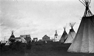
La Loche is a village in northwest Saskatchewan. It is located at the end of Highway 155 on the eastern shore of Lac La Loche in Canada's boreal forest. La Loche had a population of 2,827 in 2016 and is within the Northern Saskatchewan Administration District.

Lac Brochet 197A is a Dene Indian reserve of the Northlands Denesuline First Nation, located in the boreal forest of northern Manitoba, Canada. It is situated on the north shore of Lac Brochet, located 240 km (150 mi) northwest of the city of Thompson.

Wollaston Lake is a lake in north-eastern Saskatchewan, Canada. It is 550 kilometres (340 mi) northeast of Prince Albert. With a surface area of 2,286 square kilometres (883 sq mi), it is the largest bifurcation lake in the world – that is, a lake that drains naturally in two directions.

Fond du Lac Dene Nation is a Dene First Nation located in the boreal forest area of northern Saskatchewan, Canada. The main settlement is Fond-du-Lac, situated on the east side of Lake Athabasca. It is a remote fly-in community. The population in 2011 was 874, mainly of Dene and Métis descent. 705 residents selected Dene as their mother tongue in 2011.

Black Lake is a Denesuline First Nations band government in the boreal forest of northern Saskatchewan, Canada. It is located on the northwest shore of Black Lake where the Fond du Lac River leaves the lake to flow to Lake Athabasca.
Turnor Lake is a community on the southern shore of Turnor Lake. From Highway 155 it is accessible by Highway 909. The community includes the Northern Hamlet of Turnor Lake and Turnor Lake 193B of the Birch Narrows First Nation.

The Wollaston Lake Barge Ferry is a barge ferry that operates in the Canadian province of Saskatchewan in the Northern Saskatchewan Administration District of the province. The ferry crosses Wollaston Lake, providing a link between Highway 905 and the community of Wollaston Lake, Saskatchewan.
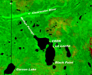
The Clearwater River Dene Nation is a Dene First Nations band government in the boreal forest area of northern Saskatchewan, Canada. It maintains offices in the village of Clearwater River situated on the eastern shore of Lac La Loche. The Clearwater River Dene Nation reserve of Clearwater River shares its southern border with the village of La Loche.

The Buffalo River Dene Nation is a Dene First Nations band government in Saskatchewan, Canada. The band's main community, Dillon, is located on the western shore of Peter Pond Lake at the mouth of the Dillon River, and is accessed by Highway 925 from Highway 155.

The English River Dene Nation is a Dene First Nation band government in Patuanak, Saskatchewan, Canada. Their reserve is in the northern section of this Canadian province. Its territories are in the boreal forest of the Canadian Shield. This First Nation is a member of the Meadow Lake Tribal Council (MLTC).
The Prince Albert Grand Council (PAGC) is a Tribal Council representing the band governments of twelve First Nations in the province of Saskatchewan. Its head offices are located in the city of Prince Albert. The Tribal Council was created in 1977 and is one of the largest in Canada.

Birch Narrows Dene Nation is a Dene First Nation band government in the boreal forest region of northern Saskatchewan, Canada. It is affiliated with the Meadow Lake Tribal Council (MLTC).

Lac la Hache 220 is an Indian reserve of the Hatchet Lake Dene Nation in Saskatchewan. It is 354 kilometers north of Flin Flon. In the 2016 Canadian Census, it recorded a population of 1377 living in 260 of its 282 total private dwellings. In the same year, its Community Well-Being index was calculated at 37 of 100, compared to 58.4 for the average First Nations community and 77.5 for the average non-Indigenous community.


