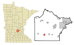
Howard Lake | |
---|---|
Motto: "Home Of The Good Neighbor" [1] | |
Coordinates: 45°4′N94°4′W / 45.067°N 94.067°W | |
Country | United States |
State | Minnesota |
County | Wright |
Area | |
• Total | 1.91 sq mi (4.94 km2) |
• Land | 1.85 sq mi (4.80 km2) |
• Water | 0.06 sq mi (0.14 km2) |
Elevation | 1,014 ft (309 m) |
Population (2020) | |
• Total | 2,071 |
• Density | 1,118.25/sq mi (431.70/km2) |
Time zone | UTC-6 (Central (CST)) |
• Summer (DST) | UTC-5 (CDT) |
ZIP codes | 55349, 55575 |
Area code | 320 |
FIPS code | 27-30284 [3] |
GNIS feature ID | 0645261 [4] |
Website | www.howard-lake.mn.us |
Howard Lake is a city in Wright County, Minnesota, United States. It is the host of the annual Wright county fair. The population was 2,071 at the 2020 census. [5]
According to the United States Census Bureau, the city has a total area of 2.05 square miles (5.31 km2); 1.77 square miles (4.58 km2) is land and 0.28 square miles (0.73 km2) is water. [6]
The town of Howard Lake sits on the south shore of Howard Lake. Other area lakes include Mallard Pass Lake, Lake Ann, Dutch Lake, and Smith Lake.
U.S. Highway 12 serves as a main route in Howard Lake. Running parallel with Route 12 is a freight rail line.
The area was first settled by the Dakota, then, in 1855, by Morgan V. Cochran, who later sold his land to Charles Goodsell in 1863. Howard Lake developed as a railroad station. [1]
Howard Lake was platted in 1869, and named after nearby Howard Lake. [7] A post office was established under the name Howard in 1870; the post office was renamed Howard Lake in 1892 and remains in operation. [8] One property in Howard Lake, the 1904 Howard Lake City Hall, is listed on the National Register of Historic Places. [9]
Census | Pop. | Note | %± |
---|---|---|---|
1880 | 477 | — | |
1890 | 610 | 27.9% | |
1900 | 737 | 20.8% | |
1910 | 626 | −15.1% | |
1920 | 744 | 18.8% | |
1930 | 768 | 3.2% | |
1940 | 847 | 10.3% | |
1950 | 931 | 9.9% | |
1960 | 1,007 | 8.2% | |
1970 | 1,162 | 15.4% | |
1980 | 1,240 | 6.7% | |
1990 | 1,343 | 8.3% | |
2000 | 1,853 | 38.0% | |
2010 | 1,962 | 5.9% | |
2020 | 2,071 | 5.6% | |
U.S. Decennial Census [10] |
As of the census [11] of 2010, there were 1,962 people, 786 households, and 518 families living in the city. The population density was 1,108.5 inhabitants per square mile (428.0/km2). There were 865 housing units at an average density of 488.7 per square mile (188.7/km2). The racial makeup of the city was 96.5% White, 0.6% African American, 0.3% Native American, 0.2% Asian, 0.1% Pacific Islander, 1.5% from other races, and 0.8% from two or more races. Hispanic or Latino of any race were 4.7% of the population.
There were 786 households, of which 35.9% had children under the age of 18 living with them, 50.5% were married couples living together, 10.1% had a female householder with no husband present, 5.3% had a male householder with no wife present, and 34.1% were non-families. 30.2% of all households were made up of individuals, and 10.2% had someone living alone who was 65 years of age or older. The average household size was 2.42 and the average family size was 2.98.
The median age in the city was 36.5 years. 27.1% of residents were under the age of 18; 6.6% were between the ages of 18 and 24; 29.5% were from 25 to 44; 22.2% were from 45 to 64; and 14.7% were 65 years of age or older. The gender makeup of the city was 48.0% male and 52.0% female.
As of the census [3] of 2000, there were 1,853 people, 735 households, and 490 families living in the city. The population density was 1,405.2 inhabitants per square mile (542.6/km2). There were 759 housing units at an average density of 575.6 per square mile (222.2/km2). The racial makeup of the city was 98.27% White, 0.27% African American, 0.16% Native American, 0.38% Asian, 0.49% from other races, and 0.43% from two or more races. Hispanic or Latino of any race were 1.03% of the population. 52.1% were of German, 8.9% Norwegian, 7.3% Swedish and 5.8% American ancestry according to Census 2000.
There were 735 households, out of which 34.1% had children under the age of 18 living with them, 51.7% were married couples living together, 10.6% had a female householder with no husband present, and 33.2% were non-families. 27.9% of all households were made up of individuals, and 12.4% had someone living alone who was 65 years of age or older. The average household size was 2.52 and the average family size was 3.10.
In the city, the population was spread out, with 28.4% under the age of 18, 9.0% from 18 to 24, 30.1% from 25 to 44, 18.6% from 45 to 64, and 13.9% who were 65 years of age or older. The median age was 33 years. For every 100 females, there were 91.0 males. For every 100 females age 18 and over, there were 89.6 males.
The median income for a household in the city was $38,015, and the median income for a family was $49,327. Males had a median income of $32,500 versus $25,040 for females. The per capita income for the city was $17,900. About 5.8% of families and 9.4% of the population were below the poverty line, including 13.0% of those under age 18 and 7.3% of those age 65 or over.
Year | Republican | Democratic | Third parties |
---|---|---|---|
2020 | 65.9%802 | 30.8% 375 | 3.3% 40 |
2016 | 64.8%614 | 26.1% 247 | 9.1% 86 |
2012 | 58.8%570 | 37.5% 364 | 3.7% 36 |
2008 | 56.7%554 | 39.9% 390 | 3.4% 33 |
2004 | 60.2%621 | 37.5% 387 | 2.3% 23 |
2000 | 54.0%442 | 35.9% 294 | 10.1% 83 |
1996 | 39.7% 288 | 45.7%332 | 43.6% 106 |
1992 | 34.9% 225 | 38.6%249 | 26.5% 171 |
1988 | 55.6%321 | 44.4% 256 | 0.0% 0 |
1984 | 58.8%357 | 41.2% 250 | 0.0% 0 |
1980 | 48.9%292 | 42.2% 252 | 8.9% 53 |
1976 | 50.2%311 | 49.0% 304 | 0.8% 5 |
1968 | 41.2% 220 | 55.4%296 | 3.4% 18 |
1964 | 40.5% 202 | 59.3%296 | 0.2% 1 |
1960 | 74.4%390 | 25.4% 133 | 0.2% 1 |
The Dura Supreme Cabinetry headquarters is in Howard Lake.
The principal employers in the city are:
# | Employer | # of Employees |
---|---|---|
1 | Dura Supreme Cabinetry | 450 |
Dura Supreme has been known to make other things like plastic shelves
Lake Crystal is a city in Blue Earth County, Minnesota, United States, established in 1869. The population was 2,539 at the 2020 census. It is part of the Mankato-North Mankato Metropolitan Statistical Area.
Benton Township is a rural township in Carver County, Minnesota, United States. The population was 753 as of the 2020 census.
Camden Township is a rural township in Carver County, Minnesota, United States. The population was 924 as of the 2020 census.
Hancock Township is a township in Carver County, Minnesota, United States. The population was 336 as of the 2020 census.
Hollywood Township is a rural township in Carver County, Minnesota, United States. The population was 1,058 as of the 2020 census.
Laketown Township is a township in Carver County, Minnesota, United States. The population was 1,966 as of the 2020 census.
Nisswa is a city in Crow Wing County, Minnesota, United States. The population was 1,971 at the 2010 census. Nisswa is part of the Brainerd Micropolitan Statistical Area, near Gull Lake.
Apple Valley is a city in northwestern Dakota County in the State of Minnesota, and a suburb of the Twin Cities. The population was 56,374 at the 2020 census, making it the 17th most populous city in Minnesota.
Farmington is a city in Dakota County, Minnesota, United States. The population was 23,632 at the 2020 census. It is a part of the Minneapolis-St. Paul metropolitan area.
Inver Grove Heights is a city in Dakota County, Minnesota, United States. The population was 35,801 at the 2020 census. The city was formed on March 9, 1965, with the merger of the village of Inver Grove and Inver Grove Township.
Mendota Heights is a city in Dakota County, Minnesota, United States. It is a first-ring southern suburb of the Twin Cities. The population was 11,744 at the 2020 census.
Greenfield is a city in northwestern Hennepin County, Minnesota. It has a population of 2,903 residents, according to the 2020 United States Census, and is located 26.5 miles northwest of Minneapolis. It is part of the Twin Cities Metropolitan Statistical Area.
Long Lake is a small city in Hennepin County, Minnesota, United States named after the lake the eastern end of town lies on. A commercial hub for the surrounding communities, Long Lake is home to many local shops and businesses. U.S. Highway 12 runs through the town. The population was 1,768 at the 2010 census.
Glencoe is a city and the county seat of McLeod County, Minnesota, United States. The population was 5,744 at the 2020 census.
Hutchinson is the largest city in McLeod County, Minnesota, United States. It lies along the South Fork of the Crow River. The population was 14,599 at the 2020 census.
Lester Prairie is a city in McLeod County, Minnesota, United States, along the South Fork of the Crow River. The population was 1,894 at the 2020 census.
Montrose is a small city in Wright County, Minnesota, United States. Montrose is surrounded by farmland, prairies, and lakes. The population was 2,847 at the 2010 census.
Arden Hills is a city in Ramsey County, Minnesota, United States. The population was 9,939 at the 2020 census. Bethel University and its seminary is located in the city. Also, the campus of University of Northwestern – St. Paul straddles the Arden Hills – Roseville border. The city contains the headquarters of Land O'Lakes and Catholic United Financial, a fraternal benefit society. Boston Scientific also has a large campus within Arden Hills as well.
Hastings is a city mostly in Dakota County, Minnesota, of which it is the county seat, with a portion in Washington County, Minnesota, United States. It is near the confluence of the Mississippi, Vermillion, and St. Croix Rivers. The population was 22,154 at the 2020 census. It is named for the first elected governor of Minnesota, Henry Hastings Sibley.
Dayton is a city in Hennepin and Wright counties in the U.S. state of Minnesota. The population was 7,262 at the 2020 census. According to 2023 census estimates, the city is estimated to have a population of 10,157. Dayton is mainly located within Hennepin County, but a part of the city extends into Wright County as well. It is the northernmost city in Hennepin County and is a suburb of the Minneapolis–St. Paul "Twin Cities" metropolitan area.
{{cite web}}
: Missing or empty |title=
(help){{cite web}}
: Missing or empty |title=
(help){{cite web}}
: Missing or empty |title=
(help){{cite web}}
: Missing or empty |title=
(help){{cite web}}
: Missing or empty |title=
(help){{cite web}}
: Missing or empty |title=
(help){{cite web}}
: Missing or empty |title=
(help){{cite web}}
: Missing or empty |title=
(help){{cite web}}
: Missing or empty |title=
(help)