
Kalaburagi, formerly known as Gulbarga, is a city in the Indian state of Karnataka, It is headquarters of eponymous Kalaburagi district and Kalaburagi division, Kalaburagi city is governed by a Municipal Corporation, It is called a Sufi city. It has famous religious structures, like the Hazrath Khwaja Banda Nawaz Dargah, the Sharana Basaveshwara Temple and the Buddha Vihar. It also has a fort built during the Bahmani rule, Other Bahmani monuments include the Haft Gumbaz and the Shor Gumbad. Kalaburagi has the world's largest cannon, Kalaburagi has a few architectural marvels built during the Bahamani Kingdom rule, including the Jama Masjid in the Kalaburagi Fort. Kalaburagi houses the circuit bench of the High Court of Karnataka. Under the name Monuments and Forts of the Deccan Sultanate, Several buildings in the city and with others in the region were put by UNESCO on its "tentative list" of World Heritage Site in 2014.

Chittoor is a city and district headquarters in Chittoor district of the Indian state of Andhra Pradesh. It is also the mandal and divisional headquarters of Chittoor mandal and Chittoor revenue division respectively. The city has a population of 189,332.

Kolar district is a district in the state of Karnataka, India.

Palar is a river of southern India. It rises in the Nandi Hills in Chikkaballapura district of Karnataka state, and flows 93 kilometres (58 mi) in Karnataka, 33 kilometres (21 mi) in Andhra Pradesh and 222 kilometres (138 mi) in Tamil Nadu before reaching its confluence into the Bay of Bengal at Vayalur about 75 kilometres (47 mi) south of Chennai. It flows as an underground river for a long distance only to emerge near Bethamangala town, from where, gathering water and speed, it flows eastward down the Deccan Plateau. The Towns of Bethamangala, Santhipuram, Kuppam, Mottur, Ramanaickenpet, Vaniyambadi, Ambur, Melpatti, Gudiyatham, Pallikonda, Anpoondi, Melmonavoor, Vellore, Katpadi, Melvisharam, Arcot, Ranipet, Walajapet, Kanchipuram, Walajabad, Chengalpattu, Kalpakkam, and Lattur are located on the banks of the Palar River. Of the seven tributaries, the chief tributary is the Cheyyar River.

Tumakuru district is an administrative district in the state of Karnataka in India. It is the third largest district in Karnataka by land area with an area of 10,598 km2, and fourth largest by Population. It is a one-and-a-half-hour drive from Bengaluru, the state capital. The district is known for the production of coconuts and is also called as 'Kalpataru Nadu'. It is the only discontiguous district in Karnataka.
Arsikere is a city and taluka in the Hassan district in the state of Karnataka, India. It is the second largest city in Hassan district, demographically. Arsikere city municipal council consists of 35 wards. This region is known for its coconut production and is also called Kalpataru Nadu. Arsikere Junction is a major railway junction in the South Western Railway which links Mangalore and Mysore to North Karnataka and a central place for tourists who visit nearby places that do not have rail access, such as Belur, Halebidu and Shravanabelagola, Harnahalli, and Kodimata.
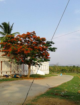
Bethamangala is a small town in the Kolar Gold Field taluk of Kolar district in the state of Karnataka, India. The town is centred around a large man-made lake created by damming the Palar river. The lake supplies drinking water to the nearby mining city of Kolar Gold Fields ("KGF"). The Bethamangala water works was established in 1903-04 and is a popular tourist site.

Kolar or Kolara is a city in the Indian state of Karnataka. It is the headquarters of Kolar district. The city is known for its milk production and gold mines. It is also known for the Someshwara and Kolaramma temples.

Chikkaballapura district is a district in the state of Karnataka, India. On 23 August 2007, it was carved out of the pre-existing Kolar district which was the fourth largest district of Karnataka by moving the talukas of Gauribidanur, Gudibanda, Bagepalli, Chikballapur, Manchenahalli, Chelur, Sidlaghatta and Chintamani into the new district. Kannada is the official language.
Hanamsagar, also spelled as Hanumasagara is a village in the Kushtagi taluk of Koppal district in Karnataka state, India.

Mothakapalli Venkatarame Gowda Krishnappa, popularly known and referred to as M.V.K. was an Indian Freedom Fighter, Indian National Congress Politician, Social Reformer and Educationist, rendered immense service for the upliftment of the rural masses throughout his illustrious career, the contributions of Krishnappa to Karnataka in general and Kolar & Chikkaballapur Districts, in particular, are noteworthy and impressive and is a household name to the people of these regions, particularly the farming community and the underprivileged cherish his memory in gratitude.
Guttahalli is a small village in the Kolar Gold Fields Taluk of Kolar district in Karnataka, India. It is situated about 4 kilometers from Kolar Gold Fields, forming the outskirts of the city.
Guttahalli is a small village in the Bangarapet Taluk of Kolar district in Karnataka, India. It is situated about 7 kilometers from Bangarapet.
Guttahalli is a small village in the Bangarapet Taluk of Kolar district in Karnataka, India. It is situated about 7 kilometers from Bangarapet.
Guttahalli is a small village in the Kolar Taluk of Kolar district in Karnataka, India. It is situated about 25 kilometers from Kolar.
Guttahalli is a small village in the Kolar Taluk of Kolar district in Karnataka, India. It is situated about 15 kilometers from Kolar.
Guttahalli is a small village in the Chintamani Taluk of Chikkaballapura district in Karnataka, India. It is situated about 12 kilometers from Chintamani.
N. G. Hulkur is a village in the Kolar Gold Fields Taluk of Kolar district in Karnataka, India. It is situated about 25 kilometers from Kolar Gold Fields, situated very close to Andhra Pradesh border.
Hulkur is a small village in the Malur Taluk of Kolar district in Karnataka, India. It is situated about 13 kilometers from Malur.
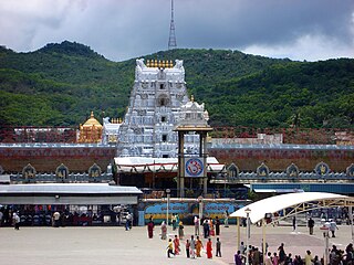
Tirupati district is one of the eight districts of Rayalaseema region in the Indian state of Andhra Pradesh. This temple built by Tamil king Thondaiman.The district headquarters is located at Tirupati city. This district is known for its numerous historic temples, including the Hindu shrine of Tirumala Venkateswara Temple and Sri Kalahasteeswara temple. The district is also home to Satish Dhawan Space Centre, a rocket launch centre located in Sriharikota. The river Swarnamukhi flows through Tirupati, Srikalahasti, Naidupeta, Vakadu and join into the Bay of Bengal.


