
Grand Canyon National Park, located in northwestern Arizona, is the 15th site in the United States to have been named as a national park. The park's central feature is the Grand Canyon, a gorge of the Colorado River, which is often considered one of the Wonders of the World. The park, which covers 1,217,262 acres of unincorporated area in Coconino and Mohave counties, received more than six million recreational visitors in 2017, which is the second highest count of all American national parks after Great Smoky Mountains National Park. The Grand Canyon was designated a World Heritage Site by UNESCO in 1979. The park celebrated its 100th anniversary on February 26, 2019.

Coconino County is a county located in the north-central part of the U.S. state of Arizona. Its population was 134,421 at the 2010 census. The county seat is Flagstaff. The county takes its name from Cohonino, a name applied to the Havasupai. It is the second-largest county by area in the contiguous United States, behind San Bernardino County, California, with its 18,661 sq mi (48,300 km2), or 16.4% of Arizona's total area, making it larger than each of the nine smallest states.

At 1.6 million acres the Kaibab National Forest borders both the north and south rims of the Grand Canyon, in north-central Arizona. It is divided into three major sections: the North Kaibab Ranger District and the South Kaibab and are managed by the United States Forest Service. The South Kaibab is further divided into two districts, the Tusayan Ranger District, and the Williams Ranger District. Grand Canyon National Park separates the North Kaibab and the South Kaibab. The South Kaibab covers 1,422 square miles (3,680 km2) and the North Kaibab stretches over 1,010 square miles (2,600 km2). Elevations vary on the forest from 5,500 feet in the southwest corner to 10,418 feet at the summit of Kendrick Peak on the Williams Ranger District. The forest as a whole is headquartered in Williams.

The Coconino National Forest is a 1.856-million acre United States National Forest located in northern Arizona in the vicinity of Flagstaff. Originally established in 1898 as the "San Francisco Mountains National Forest Reserve", the area was designated a U.S. National Forest in 1908 when the San Francisco Mountains National Forest Reserve was merged with lands from other surrounding forest reserves to create the Coconino National Forest. Today, the Coconino National Forest contains diverse landscapes, including deserts, ponderosa pine forests, flatlands, mesas, alpine tundra, and ancient volcanic peaks. The forest surrounds the towns of Sedona and Flagstaff and borders four other national forests; the Kaibab National Forest to the west and northwest, the Prescott National Forest to the southwest, the Tonto National Forest to the south, and the Apache-Sitgreaves National Forest to the southeast. The forest contains all or parts of ten designated wilderness areas, including the Kachina Peaks Wilderness, which includes the summit of the San Francisco Peaks. The headquarters are in Flagstaff. There are local ranger district offices in Flagstaff, Happy Jack, and Sedona.

Red Butte is a butte located in the Kaibab National Forest in Coconino County, Arizona. It is known to the Havasupai nation as Wii'i Gdwiisa, "clenched fist mountain," and is regarded as a sacred site.

The Coconino Plateau is found south of the Grand Canyon and north-northwest of Flagstaff, in northern Arizona of the Southwestern United States.

Jacob Lake is a small unincorporated community on the Kaibab Plateau in Coconino County, Arizona, United States, at the junction of U.S. Route 89A and State Route 67. Named after the Mormon explorer Jacob Hamblin, the town is known as the "Gateway to the Grand Canyon" because it is the starting point of Route 67, the only paved road leading to the North Rim of the Grand Canyon some 44 miles (71 km) to the south. The town itself consists of the Jacob Lake Inn which maintains motel rooms and cabins, a restaurant, lunch counter, gift shop, bakery, and general store; a gas station/garage; campground; and a visitors center run by the U.S. Forest Service. In the summer months, there is also a nearby center for horse rides.

Sycamore Canyon Wilderness is a 56,000-acre wilderness area in the Coconino, Kaibab and Prescott national forests in the U.S. state of Arizona. Encompassing Sycamore Canyon and its surrounds from south of Williams to the confluence of Sycamore Creek with the Verde River, the wilderness is about 40 miles (64 km) southwest of Flagstaff. The canyon is one of several in Arizona that cut through the Mogollon Rim. Relevant United States Geological Survey (USGS) map quadrangles are Davenport Hill, White Horse Lake, May Tank Pocket, Perkinsville, Sycamore Basin, and Clarkdale. Red Rock-Secret Mountain Wilderness borders Sycamore Canyon Wilderness on the east.

The Grand Canyon Lodge is a hotel and cabins complex at Bright Angel Point on the North Rim of the Grand Canyon. It was designed by Gilbert Stanley Underwood, who designed a number of other hotels in national parks for the Utah Parks Company and other concessioners. Built in 1927–28, the Grand Canyon Lodge resort complex consists of the Main Lodge building, 23 deluxe cabins, and 91 standard cabins, some of which were moved to the north rim campground in 1940. All guests are housed in cabins detached from the main lodge, which serves as a dining, concessions and service facility. Constructed of native Kaibab limestone and timber, the complex was designed to harmonize with its rocky and forested setting. The Grand Canyon Lodge complex is notable for its setting and rustic design, as well as its status as the only complete surviving lodge and cabin complex in the national parks.

Grand Canyon Village Historic District comprises the historic center of Grand Canyon Village, on the South Rim of the Grand Canyon in Grand Canyon National Park, Arizona. The district includes numerous landmark park structures, many of which are National Historic Landmarks themselves, or are listed on the National Register of Historic Places. The town design as a whole is also significant for its attention to integration with the Grand Canyon landscape, its incorporation of National Park Service Rustic design elements, and for the idiosyncratic design of park concessioner structures such as the El Tovar Hotel.
Kanab Creek Wilderness is a 75,300-acre (305 km2) wilderness area located along the Coconino/Mohave County line in the U.S. state of Arizona, approximately 30 miles (48 km) south of Fredonia. 68,600 acres (278 km2) of the Wilderness are located in the North Kaibab Ranger District of the Kaibab National Forest, the remaining 6,700 acres (27 km2) are administered by the Arizona Bureau of Land Management.
The Moqui Ranger Station in Kaibab National Forest near Tusayan, Arizona, also known as Tusayan Ranger Station, was built in 1939 by the Civilian Conservation Corps (CCC). It was listed on the National Register of Historic Places in 1993 for its architecture, which includes Bungalow architecture, Rustic architecture, vernacular and other styling. It was designed by the USDA Forest Service. The listing includes institutional housing and government office space in six contributing buildings and one other contributing structure over 2 acres (0.81 ha) In addition to CCC labor, workers from the Works Progress Administration (WPA) may have also been involved in the ranger station construction. The station replaced the old Hull Tank Ranger Station.

A lookout tree is a simple fire lookout tower created by attaching a ladder or a series of spikes to a tall straight tree with a view of the surrounding lands, allowing rangers or fire crews to conveniently climb the tree to survey their surroundings. The simplest kind consist only of a ladder to a suitable height: this kind was called a "ladder tree." Some ladder trees had platforms on the ground next to them for maps and a fire finder. A more elaborate version often created a platform on top of the tree trunk by cutting off approximately the last 10 feet (3.0 m) of the treetop and building a railed wooden platform on the resulting stump. These "platform trees" were often equipped with telephones, fire finder tables, seats and guy wires. Accommodation for the watcher was provided by a tent or shelter at the bottom of the tree.
The lookout trees in Kaibab National Forest are the survivors of a system of improvised fire lookout towers that used tall, straight trees as vantage points. The practice of using trees as lookouts was widespread in the western United States during the early 20th century, as there was no need to build a foundation or to pack and assemble a tower structure. Instead, a prominent tree could be selected, and a ladder or a series of spikes could be attached to the tree trunk. For transient use this could be all that was done, but for more permanent use the top 10 feet (3.0 m) of the tree could be lopped, and a platform constructed on the resulting stump. This railed platform was then outfitted with a seat and a platform for an Osborne Fire Finder.
Architects of the National Park Service are the architects and landscape architects who were employed by the National Park Service (NPS) starting in 1918 to design buildings, structures, roads, trails and other features in the United States National Parks. Many of their works are listed on the National Register of Historic Places, and a number have also been designated as National Historic Landmarks.

The Grand View Lookout Tower is a fire lookout in Kaibab National Forest near the South Rim of the Grand Canyon. The 80-foot (24 m) tall steel tower was built in the 1930s. Its observation cabin measures 7 feet (2.1 m) square. A small cabin is included in the designated area.

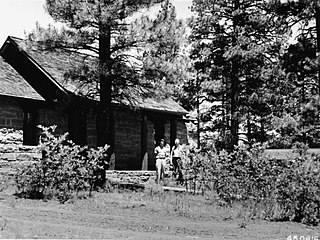
The Jacob Lake Ranger Station is a historic U.S. Forest Service ranger station in the unincorporated community of Jacob Lake, Arizona, United States, that is listed on the National Register of Historic Places (NRHP).

Big Springs is an unincorporated community in Coconino County, Arizona, United States. Big Springs is located in Kaibab National Forest, 10.8 miles (17.4 km) southwest of Jacob Lake.


