
Cedar Rapids is a city in and the county seat of Linn County, Iowa, United States. The population was 137,710 at the 2020 census, making it the second-most populous city in Iowa. The city lies on both banks of the Cedar River, 20 miles (32 km) north of Iowa City and 128 miles (206 km) northeast of Des Moines, the state's capital.

Conservation and restoration of immovable cultural property describes the process through which the material, historical, and design integrity of any immovable cultural property are prolonged through carefully planned interventions. The individual engaged in this pursuit is known as an architectural conservator-restorer. Decisions of when and how to engage in an intervention are critical to the ultimate conservation-restoration of cultural heritage. Ultimately, the decision is value based: a combination of artistic, contextual, and informational values is normally considered. In some cases, a decision to not intervene may be the most appropriate choice.

The tornado outbreak sequence of June 3–11, 2008 was a series of tornado outbreaks affecting most of central and eastern North America from June 3–11, 2008. 192 tornadoes were confirmed, along with widespread straight–line wind wind damage. Seven people were killed from a direct result of tornadoes; four in Iowa, two in Kansas, and one in Indiana. Eleven additional people were killed across five states by other weather events including lightning, flash flooding, and straight-line winds. Severe flooding was also reported in much of Indiana, Wisconsin, Minnesota and Iowa as a result of the same thunderstorms, while high heat and humidity affected much of eastern North America; particularly along the eastern seaboard of the United States from New York City to the Carolinas.

The Iowa flood of 2008 was a hydrological event involving most of the rivers in eastern Iowa which began June 8 and continued until July 1. Flooding continued on the Upper Mississippi River in the southeastern area of the state for many more days. The phrase "Iowa's Katrina" was often heard.

The Burlington, Cedar Rapids and Northern Railway (BCR&N) was a railroad that operated in the United States from 1876 to 1903. It was formed to take over the operations of the bankrupt Burlington, Cedar Rapids and Minnesota Railway, which was, in turn, the result of merging several predecessor lines, the construction of which began in 1869. The corporate headquarters were in Cedar Rapids, Iowa, and it had operations in Iowa and in Minnesota. It was succeeded by the Chicago, Rock Island and Pacific Railway.

The Davenport Hotel was a historic building located in downtown Davenport, Iowa, United States. It was individually listed on the National Register of Historic Places in 1983. In 2020 it was included as a contributing property in the Davenport Downtown Commercial Historic District. It was an apartment building called The Davenport. A rear portion of the building collapsed in 2023. The majority of the building was demolished on June 12, 2023. Several remaining sections were demolished over the next three days.
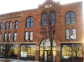
The C.S.P.S. Hall in Cedar Rapids, Iowa, USA was built during 1890-91 and expanded twice in the next two decades. It was a social and cultural center of the local Czech-Slovak Protective Society (C.S.P.S.). The building was individually listed on the National Register of Historic Places in 1978. In 2002 it was included as a contributing property in the Bohemian Commercial Historic District.
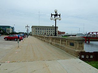
The Civic Center Historic District is located in downtown Des Moines, Iowa, United States. It flanks both the Des Moines and Raccoon Rivers and their confluence. The district has been listed on the National Register of Historic Places since 1988. It is part of The City Beautiful Movement and City Planning in Des Moines, Iowa 1892—1938 MPS.

The Des Moines Saddlery Company Building is a historic building located in downtown Des Moines, Iowa, United States. It was built in 1881 by J. Rubelman of Muscatine, Iowa. He choose to move his operation to Des Moines because of its location on two rivers and the 13 railroads that served the city. It was one of four saddlery firms in a two block area. Rubelman's company made saddles, harnesses and leather works for 20 years. In the years since it has housed a shoe maker, rubber company, stove manufacturer, glove company, the Krispy Kone Company and the Kaplan Hat Company. The later was also the name of the restaurant that was located on the first floor.

The McHaffey Opera House is a historic building located in Eldon, Iowa, United States. It was constructed in 1891 and in use by the community through the 1940s. The building was mainly unused for many decades until a volunteer community group bought the opera house in 1995 and began restoration efforts. The McHaffey Opera House was placed on the National Register of Historic Places in November, 1995.

A destructive derecho event struck the states of Iowa, Illinois, Michigan, and Ohio on July 11, 2011, and was the most damaging portion of a much larger derecho event known as The Cross Country Derecho of July 2011. It started on the morning of July 11, 2011, when a powerful long-lasting straight-line windstorm, known as a derecho, developed over central Iowa and carved a path of extensive damage across east central Iowa. The storms first took shape as a cluster of low-end severe storms over Southern Nebraska during the late afternoon of July 10. The system continued northeastward and entered western Iowa at 1:00 a.m, still only as a marginal line of severe storms. As the system passed through the Northern Des Moines metro area at 3:30 a.m., it interacted with an outflow boundary from the storms to the north and rapidly intensified as it accelerated eastward. Over the next hour and a half the storm plowed eastward through Story, Marshall, and Tama Counties, blasting the area with winds of up to 105 miles per hour (169 km/h). The storm continued to track eastward, plowing through eastern Iowa and the Southern Great Lakes region before dissipating in West Virginia in the mid-afternoon. Thousands of trees were downed in western Iowa alone, and numerous structures were either damaged or destroyed. The peak winds were estimated to be in the range of 130 miles per hour (210 km/h), equal to a Category 4 hurricane. One man was killed in Grand Rapids, Michigan due to a falling tree.
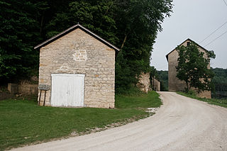
Motor is an unincorporated community in Clayton County, Iowa, United States. The townsite is also a nationally recognized historic district listed as a historic site on the National Register of Historic Places in 1977.

The conservation and restoration of lighthouses is when lighthouse structures are preserved through detailed examination, cleaning, and in-kind replacement of materials. Given the wide variety of materials used to construct lighthouses, a variety of techniques and considerations are required. Lighthouses alert seagoers of rocky shores nearby and provide landmark navigation. They also act as a physical representation to maritime history and advancement. These historic buildings are prone to deterioration due to their location on rocky outcrops of land near the water, as well as severe weather events, and the continued rise of sea levels. Given these conditions preservation and conservation efforts have increased.
The Spaulding Manufacturing Company is a complex of historic buildings located in Grinnell, Iowa, United States. Vermont native H.W. Spaulding settled in Grinnell in 1876 to open a blacksmith and wagon repair shop. Not long after, he started to manufacture wagons. Because of his modest success he entered into a series of partnerships over the years. The oldest building in the complex was completed around 1880, and the company grew to a complex of five buildings. The last building was completed in 1910, and has a masonry chimney that originally rose to 110 feet (34 m) high. All the buildings are brick construction, and they range in height from two floors to three floors. As modes of transportation began to change, so did Spaulding. The company began manufacturing automobiles. They were one of several early automobile manufacturers that had existing operations that manufactured bicycles, wagons, and carriages. They went out of business in 1929. Since that time the facility has housed a variety of small-scale manufactures, and even a veterinary clinic. Part of the plant was renovated and now houses the administration offices for the City of Grinnell and displays for the Iowa Transportation Museum, which is now closed due to a variety of financial issues. The largest buildings of the manufacturing complex were renovated and converted into the Spaulding Lofts apartments. The complex was listed on the National Register of Historic Places in 1978.
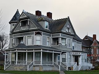
The Frank G. Ray House & Carriage House, also known as Ray Towers, is a historic residence located in Vinton, Iowa, United States. Ray was a local businessman who was associated with the Iowa Canning Company, the largest corporation in Benton County and a major employer in the region. His 2½-story frame Queen Anne house features a complex composition that includes a wraparound front porch, three decorative chimneys, a three-story round tower, porte-cochère, and small porches at various places on all stories. The carriage house features decorative shingles and an irregular roofline that is capped with a cupola and weather vane. They were listed together on the National Register of Historic Places in 1982.

The Vinton Public Library is located in Vinton, Iowa, United States.
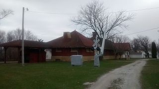
The Burlington, Cedar Rapids & Northern Passenger Station-Vinton, also known as Rock Island Depot and the Vinton Depot, is a historic building located in Vinton, Iowa, United States. Completed in 1900, this depot replaced a previous depot of the Burlington, Cedar Rapids and Northern Railway (BCR&N) located on the east side of town. It was designed by the railroad's architect and chief engineer, H.F. White, and built by A.H. Connor & Company of Cedar Rapids. The single-story brick structure was constructed on a limestone foundation. Three years after it was built, the BCR&N was acquired by the Chicago, Rock Island and Pacific Railroad. It continued to serve as a working depot until 1967. The Benton County Historical Society restored the depot and converted into a railroad museum. The building was listed on the National Register of Historic Places in 1990.

Decorah Woolen Mill, also known as the Meritol Building or Decorah Tire Service, is a historic building located in Decorah, Iowa, United States. The mill was originally constructed in 1867, and was operated by various owners in the years to come. They included the Decorah Glove and Mitten Works who operated in the building the same year, 1908, that it was struck by a tornado. The third floor sustained damage, and they continued operations here. By 1919 they were no longer in business here and the American Drug and Press Association, the Meritol Company, bought the building and expanded it. They made pharmaceuticals and patent medicines, and went bankrupt in 1932. Various other companies operated from here until 1955 when Decorah Tire Service took over. The building was individually listed on the National Register of Historic Places in 2001. The property was developed into a 15-unit apartment building, which opened in 2002. In 2017 it was included as a contributing property in the Decorah Commercial Historic District.

The Studebaker Corporation Branch Office Building, also known as the Iowa Truck and Tractor Co., Apperson Iowa Motor Car Co., Sears Auto Co., and the Sanders Motor Co., is a historic building located in Des Moines, Iowa, United States. This is actually two adjacent buildings, built four years apart. The building at 1442 Locust Street was completed in 1918 to house a Studebaker dealership, auto repair shop, and a corporate branch office. The addition of the corporate office made this building different from the others on Des Moines' "Auto Row," where it is located. The building was designed by the prominent local architectural firm of Proudfoot, Bird & Rawson, and built for the Hubbell Building Company who leased it out. The first floor was the location for Glass & Patton, the local Studebaker dealer. The second floor was where Studebaker's wholesale business in the state of Iowa was conducted. The third floor was a store room for automobiles. Studebaker's tenure here was short-lived, and by 1919 other auto and truck related businesses started to occupy the building.
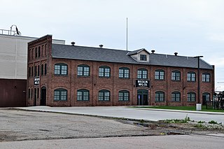
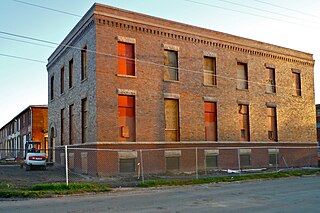
Albertson and Company-Rocklin Manufacturing Company is a historic building located in Sioux City, Iowa, United States. Completed in 1912, the building initially housed Automatic Valve Seating Mach Co. They reorganized in 1914 and became the Sioux City Machine and Tool Company, which produced spark plugs and tire valves. The company failed four months later and the shop foreman, Frans Oscar Albertson, formed Albertson & Co. and took over the plant. During World War I they supplied 6,000 piston rings and repair tools for munition plants for Canada. Albertson never owned the building and moved his operations to another Sioux City building in 1920. The company went on to become the largest manufacturer of portable electronic and air tools in the world. They changed their name to Sioux Tools Inc., and in 1993 they became a division of Snap-On Tools. Their manufacturing facility moved to North Carolina in 2001.


