This is a list of the extreme points of the United Kingdom: the points that are farther north, south, east or west than any other location. Traditionally the extent of the island of Great Britain has stretched "from Land's End to John o' Groats".

The Executive Committee Range is a range consisting of five major volcanoes, which trends north-south for 50 nautical miles along the 126th meridian west, in Marie Byrd Land, Antarctica.

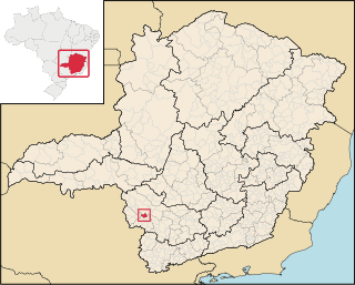
Barra Longa is a Brazilian municipality located in the state of Minas Gerais. Its population as of 2020 is estimated to be 5,015 people living in a total area of 386.101 km2. The city belongs to the mesoregion of Zona da Mata and to the microregion of Ponte Nova.
The Rockefeller Mountains are a group of low-lying, scattered granite peaks and ridges, almost entirely snow-covered, standing 30 nautical miles south-southwest of the Alexandra Mountains on the Edward VII Peninsula of Antarctica.

Gaurama is a municipality in the state of Rio Grande do Sul, Brazil. As of 2020, the estimated population was 5,489.

Ibiaçá is a municipality in the state of Rio Grande do Sul, Brazil. As of 2020, the estimated population was 4,699.

Penguin Bank is the name given to a now-submerged shield volcano of the Hawaiian Islands. Its coral-capped remains lie immediately west of the island of Molokaʻi, under relatively shallow water.
Bom Jesus da Penha is a Brazilian municipality located in the southwest of the state of Minas Gerais. Its population as of 2020 was 4,244 people living in a total area of 209 km². The city belongs to the mesoregion of Sul e Sudoeste de Minas and to the micro-region of Passos. It became a municipality in 1963.

Capetinga is a Brazilian municipality located in the southwest of the state of Minas Gerais. Its population as of 2020 was 6,890 people living in a total area of 296 km². The city belongs to the meso-region of Sul e Sudoeste de Minas and to the micro-region of Passos. It became a municipality in 1938.
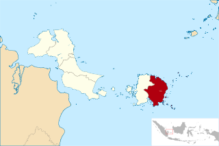
East Belitung Regency is a regency (kabupaten) of Bangka Belitung Islands Province, Indonesia, encompassing the eastern half of Belitung Island. It covers an area of 2,506.91 km2 and had a population of 106,463 at the 2010 Census and 127,018 at the 2020 Census; the official estimate as at mid 2022 was 130,463 - comprising 67,145 males and 63,318 females. Its regency seat is the town of Manggar.
Towallum River, a perennial river of the Clarence River catchment, is located in the Northern Tablelands region of New South Wales, Australia.
The Land Glacier is a broad, heavily crevassed glacier, about 35 nautical miles long, descending into Land Bay in Marie Byrd Land, Antarctica. It was discovered by the United States Antarctic Service (1939–41) and named for Rear Admiral Emory S. Land, Chairman of the United States Maritime Commission.
Barbosa Ferraz, Paraná is a municipality in the state of Paraná in the Southern Region of Brazil.
Peabiru is a municipality in the state of Paraná in the Southern Region of Brazil.
Moreira Sales is a municipality in the state of Paraná in the Southern Region of Brazil.

Paranacity is a municipality in the state of Paraná in the Southern Region of Brazil.
Uniflor is a municipality in the state of Paraná in the Southern Region of Brazil.
Neuburg Peak is a jagged rock peak in Antarctica, 1,840 metres (6,040 ft) high, rising 2.5 nautical miles east of Walker Peak in the southwest part of Dufek Massif, Pensacola Mountains.
Paradise Harbour is a wide embayment behind Lemaire Island and Bryde Island, indenting the west coast of Graham Land, Antarctica, between Duthiers Point and Leniz Point. The name was first applied by whalers operating in the vicinity and was in use by 1920.

