The Northern United States, commonly referred to as the American North, the Northern States, or simply the North, is a geographical or historical region of the United States.

California's Colorado Desert is a part of the larger Sonoran Desert. It encompasses approximately 7 million acres, including the heavily irrigated Coachella and Imperial valleys. It is home to many unique flora and fauna.
This is a list of the extreme points of Ireland – the points that are farthest north, south, east or west in Ireland. It includes the Republic of Ireland and Northern Ireland.
The extreme points of Norway include the coordinates that are farther north, south, east or west than any other location in Norway; and the highest and the lowest altitudes in the country. The northernmost point is Rossøya on Svalbard, the southernmost is Pysen in Mandal, the easternmost is Kræmerpynten on Svalbard, and the westernmost is Hoybergodden on Jan Mayen. The highest peak is Galdhøpiggen, standing at 2,469 m (8,100 ft) above mean sea level, while the lowest elevation is sea level at the coast.

Conceição da Barra is the northernmost municipality in the Brazilian state of Espírito Santo. The city is also the northernmost coastal city of the state. Its population was 31,273 (2020) and its area is 1,188.044 km².

Cape Sōya is the northernmost point of the island of Hokkaidō, Japan. It is situated in Wakkanai, Sōya Subprefecture. The Monument of the Northernmost Point of Japan (日本最北端の地の碑) is at the cape, although the true northernmost point under Japanese control is a small deserted island called Bentenjima, 1 kilometre (3,300 ft) northwest. Since the cape is just 43 kilometres (27 mi) away across La Perouse Strait from Cape Crillon, Sakhalin Island, Russia, it is possible to catch a glimpse of the island of Sakhalin on a clear day.
Balasore District also known as Baleswar District or Baleshwar District, is an administrative district of Odisha state, in eastern India. Balasore is one of the coastal districts of Odisha and lies on the northernmost part of the state.

California's 17th congressional district is a congressional district in the U.S. state of California that is currently represented by Ro Khanna. It is located in the South Bay and East Bay regions of the San Francisco Bay Area.
This is a list of points in the Philippines that are farther north, south, east, or west than any other location in the country. Also included are extreme points in elevation, extreme distances, and other points of geographic interest.

The Conondale Range is a mountain range in Queensland, located between Maleny, Kenilworth, Kilcoy and Jimna. The range is the most westerly part of the Sunshine Coast hinterland and part of the Great Dividing Range. The highest point on the range is Mount Langley reaching 868 m above sea level. This is also the highest point in the Brisbane River catchment.
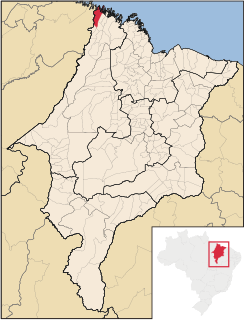
Carutapera is the northernmost city in the Brazilian state of Maranhão.

Apiacás is the northernmost municipality in the Brazilian state of Mato Grosso. It is the only city in a territorial "edge" of Mato Grosso that "pierce" the boundary between Amazonas and Pará.
Almeirim is a city on the Amazon and the northernmost municipality in the Brazilian state of Pará. It is also the fourth largest municipality in that state and the eighth largest in Brazil. The municipality is crossed by the Equator.

Belém do Brejo do Cruz is the northernmost municipality in the Brazilian state of Paraíba.

Jardim Olinda is the northernmost city in the Brazilian state of Paraná. The Saran Grande waterfall, located there, is the northernmost point in the state and in all Southern Brazil.