This article relies largely or entirely on a single source .(March 2019) |
Sapucaia do Sul | |
|---|---|
 Flag  Seal | |
| Motto: Attitude, willpower and eyes on the future | |
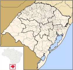 | |
 Sapucaia do Sul Location in Brazil | |
| Coordinates: 29°50′20″S51°08′38″W / 29.83889°S 51.14389°W | |
| Country | Brazil |
| Region | South |
| State | Rio Grande do Sul |
| Founded | 1961 |
| Government | |
| • Mayor | Volmir Rodrigues (PP) |
| Area | |
• Total | 58.309 km2 (22.513 sq mi) |
| Elevation | 35 m (115 ft) |
| Population (2022 [2] ) | |
• Total | 132,107 |
| • Density | 2,265.6/km2 (5,868.0/sq mi) |
| Time zone | UTC−3 (BRT) |
| Website | sapucaiadosul.rs.gov.br |
Sapucaia do Sul is a municipality in the state of Rio Grande do Sul, Brazil. It is located in the south of Brazil, in the region of "Vale dos Sinos".
Sapucaia do Sul is a commercial city, and some industries have been there since the 1960s. The city is crossed by BR-116, one of the most important roads in Brazil. The coordinates of this place are -29.829, -51.144. As of 2020, the city has a population of 141,808.
One of its main touristic attractions is the Zoo Park. [3]

