Campo Bom

Last updated
Município de Campo Bom
Vista de Campo Bom.jpg
View of Campo Bom
Bandeira de Campo Bom.png
Coat of arms of Campo Bom RS.png
Nickname: 
The Little Giant of the Valley
Locator map of Campo Bom in Rio Grande do Sul.svg
Coordinates: 29°40′44″S51°03′10″W / 29.67889°S 51.05278°W / -29.67889; -51.05278
Country Brazil
Region South
State Rio Grande do Sul
Founded1829
Incorporated1959
Area
  Total61 km2 (24 sq mi)
Elevation
29 m (95 ft)
Population
 (2020 [1] )
  Total69,458
  Density992.79/km2 (2,571.3/sq mi)
Time zone UTC−3 (BRT)
Website campobom.rs.gov.br

Campo Bom is a town located in the valley of the Sinos River, in the State of Rio Grande do Sul, Brazil. It belongs to the Greater Porto Alegre area.

Contents

The city is known as "The little giant of the valley", and it has a diversified industrial economy, including automotive, metallurgical, chemical, pottery and glass industries. Due to its initial development to the footwear sector it is known, along with its neighbour Novo Hamburgo, as the "national shoemaking capital". The town exports to several countries, including Portugal, China, Germany and the United States. [2]

It is one of the most developed cities throughout the State of Rio Grande do Sul. Education, health, leisure and quality of life in the city are references in the Country. The town was also the first city in Brazil to offer free Internet available to 100% of the population and the first dedicated bicycle path in South America built in 1977 having now over 22,000 metres in total, of which 8,000 metres surrounds the city's centre. [3]

History

The colonisation of the town started in 1825 with German immigrants who settled in the town centre, along what is now known as Avenida Brasil. [4] They were mostly Protestants of Lutheran denomination. In 1829 they built the first evangelic temple in southern Brazil. [3]

Initially, agriculture was the only economic activity. Afterwards landmarks such as the Deuner Mill started being built and also brought more economic activity to the town. More recently the Shoemaking Industry, with factories like Reichert, Schutz, Arezzo and Schmidt Irmãos, and commerce have been the main contributors to the town's economic success.

Campo Bom was elevated to a district of São Leopoldo in 1926. The district evolved and was awarded emancipation in January 31, 1959. [4] [5]

The origin of the municipality's name came from the drovers who drove cattle from the Campos de Cima da Serra to São Leopoldo and Porto Alegre, passing through the town. The drovers rested in the shade of trees while the cattle grazed in the good field of the city (good field means Campo Bom). [4]

Geography

Located on the lower slope of the northeast of the state, at latitude 29º40'44" S and longitude 51º03'10" W, Campo Bom is at an altitude of 29 meters above sea level. Its population in 2021 was 69,981 inhabitants. It is located 56.8 km from Porto Alegre, the state capital, via asphalt roads. [1]

It is a municipality that relies on the waters of the Sinos River and records the highest temperatures in the state of Rio Grande do Sul in the summer, and even sometimes during the rest of the year.

According to INMET, relating to the year 1985 and the periods from 1988 to 1998, 2000 and from 2002 onwards, the city's highest recorded temperature was 41.9 °C (107.4 °F) in November 16, 1985, and the lowest was -1.8 °C (28,7 °F) in July 14, 2000, July 25, 2009 and June 8, 2012. The highest precipitation in 24 hours was 209 mm in June 16, 2023 breaking the old record from April 23, 2011, with 154 mm. [6]

Economy

Firsly, agriculture was the only economic activity. The emergence of the footwear industry, and also of brickworks, were responsible for boosting the local economy. In the 70s, boosted by the footwear industry, the city received several immigrants from other regions of the state.

Sports

The city's soccer team, Clube 15 de Novembro has a regional prominence, despite having closed its professional division in 2008 and again in 2013 after financial problems. The headquarters of this club resembles Germanic architecture. Currently, 15 de Novembro has departments for various sports like tennis, shooting, soccer academies, archery, handball and chess, in addition to the swimming pools department. [7]

Culture

The culture of the community is deeply linked to German colonization, the taste for singing, dancing and traditions brought from the distant homeland, gave rise to the societies Concórdia (Current 15 November), the Clube Recreativo e Cultural Oriente and Sociedade e Canto Progresso

The attachment to Rio Grande do Sul's traditions is also present through the rural rodeos carried out by the Gaucho Tradition Centers (in Portuguese: Centro de Tradições Gaúchas - CTG) Campo Verde, M'Bororé, Palanques da Tradição and Guapos do Itapuí.

The city has a theater and two cinemas with modern infrastructure, at the Campo Bom Integrated Education Center (in portuguese: Centro de Educação Integrada - C.E.I), where the bus station is also located. One of the movie theaters is named after the actress Bárbara Paz, who was born in Campo Bom. [8]

The majority of the city's population is made up of German and Italian descendants, but there is also a minority of Portuguese, Spanish and Polish descendants. Alongside the national language, portuguese, the German language is considered a cultural heritage of the city, protected by IPHAN since 2008.

Climate

Climate data for Campo Bom (1981–2010)
MonthJanFebMarAprMayJunJulAugSepOctNovDecYear
Mean daily maximum °C (°F)32.2
(90.0)
31.6
(88.9)
30.6
(87.1)
27.2
(81.0)
23.1
(73.6)
20.9
(69.6)
20.5
(68.9)
22.7
(72.9)
23.5
(74.3)
26.8
(80.2)
29.4
(84.9)
31.6
(88.9)
26.7
(80.1)
Daily mean °C (°F)24.9
(76.8)
24.3
(75.7)
23.3
(73.9)
20.1
(68.2)
16.1
(61.0)
14.3
(57.7)
13.5
(56.3)
15.2
(59.4)
16.7
(62.1)
19.7
(67.5)
22.0
(71.6)
24.0
(75.2)
19.5
(67.1)
Mean daily minimum °C (°F)19.4
(66.9)
19.4
(66.9)
18.5
(65.3)
15.4
(59.7)
11.7
(53.1)
10.0
(50.0)
9.0
(48.2)
10.2
(50.4)
11.8
(53.2)
14.5
(58.1)
16.2
(61.2)
18.1
(64.6)
14.5
(58.1)
Average precipitation mm (inches)139.5
(5.49)
130.7
(5.15)
113.7
(4.48)
121.5
(4.78)
110.7
(4.36)
132.6
(5.22)
149.4
(5.88)
131.9
(5.19)
168.0
(6.61)
154.2
(6.07)
115.5
(4.55)
114.5
(4.51)
1,582.2
(62.29)
Average precipitation days (≥ 1.0 mm)10109989109101089111
Average relative humidity (%)75.078.279.582.384.084.982.980.879.977.273.472.979.3
Source: Instituto Nacional de Meteorologia [9]

See also

Related Research Articles

<span class="mw-page-title-main">Porto Alegre</span> Capital and largest city of Rio Grande do Sul, Brazil

Porto Alegre is the capital and largest city of the Brazilian state of Rio Grande do Sul. Its population of 1,488,252 inhabitants (2020) makes it the 12th-most populous city in the country and the center of Brazil's fifth-largest metropolitan area, with 4,405,760 inhabitants (2010). The city is the southernmost capital city of a Brazilian state.

<span class="mw-page-title-main">Rio Grande do Sul</span> State of Brazil

Rio Grande do Sul is a state in the southern region of Brazil. It is the fifth-most populous state and the ninth-largest by area. Located in the southernmost part of the country, Rio Grande do Sul is bordered clockwise by Santa Catarina to the north and northeast, the Atlantic Ocean to the east, the Uruguayan departments of Rocha, Treinta y Tres, Cerro Largo, Rivera, and Artigas to the south and southwest, and the Argentine provinces of Corrientes and Misiones to the west and northwest. The capital and largest city is Porto Alegre. The state has the highest life expectancy in Brazil, and the crime rate is relatively low compared to the Brazilian national average. Despite the high standard of living, unemployment is still high in the state, as of 2017. The state has 5.4% of the Brazilian population and is responsible for 6.6% of the Brazilian GDP.

<span class="mw-page-title-main">Nova Petrópolis</span> Municipality in Rio Grande do Sul, Brazil

Nova Petrópolis is a municipality in the Southern Brazilian state of Rio Grande do Sul. The main seat of the municipality is also called Nova Petrópolis. It is located in the Serra Gaúcha region, at 29º22'35" South, 51º06'52" West, about 90 km (56 mi) north of Porto Alegre, the state capital city. Nova Petrópolis is situated at an average altitude of 580 m (1,900 ft) above sea level and covers an area of 293 km2 (113 sq mi).

<span class="mw-page-title-main">Novo Hamburgo</span> Municipality in South, Brazil

Novo Hamburgo is a municipality in the southernmost Brazilian state of Rio Grande do Sul, located in the metropolitan area of Porto Alegre, the state capital. As of 2020, its population was 247,032. The city covers an area of 217 km2 (84 sq mi), and the average temperature is 19 °C (66 °F), which is mild for the region. The Sinos River runs through the urban area.

<span class="mw-page-title-main">Santa Maria, Rio Grande do Sul</span> Municipality in the state of Rio Grande do Sul, Brazil

Santa Maria is a municipality (município) in the central region of Rio Grande do Sul, the southernmost state of Brazil. In 2020, its population was 283,677 inhabitants in a total area of 1,823 square kilometres (704 sq mi). Santa Maria is the 5th biggest municipality in the state, and the largest in its micro-region.

<span class="mw-page-title-main">Lages</span> Municipality in South, Brazil

Lages is a Brazilian municipality located in the central part of the state of Santa Catarina, in the region known in Portuguese as "Planalto Serrano".

<span class="mw-page-title-main">Passo Fundo</span> Municipality in South, Brazil

Passo Fundo is a municipality in the north of the southern Brazilian state of Rio Grande do Sul. It is named after its river. It's the twelfth largest city in the state with an estimated population of 204,722 inhabitants living in a total municipal area of 780 km2.

<span class="mw-page-title-main">Bagé</span> Municipality in South, Brazil

Bagé is a Brazilian municipality located in the state of Rio Grande do Sul. In 2020, its population was 121,335 in a total area of 4,096 km2. It is the seventeenth largest city in the state according to the 2011 census. The city was founded in 1811 and given city status in 1859. Due to its strategic border location, Bagé has remained of significant military importance. Prior to official reorganization as a city, Bagé was seized by military forces from Uruguay and Argentina.

<span class="mw-page-title-main">Gravataí</span> Municipality in South, Brazil

Gravataí is a Brazilian municipality near Porto Alegre at the Rio Grande do Sul State. Its population is approximately 280,000 people, making it the sixth most populous city in the state.

<span class="mw-page-title-main">Esporte Clube Novo Hamburgo</span> Soccer club

Esporte Clube Novo Hamburgo, commonly referred to as Novo Hamburgo, is a Brazilian football club based in Novo Hamburgo, Rio Grande do Sul. It currently plays in Campeonato Gaúcho Série A, the first level of the Rio Grande do Sul state football league.

<span class="mw-page-title-main">Canoas</span> Municipality in South, Brazil

Canoas is a municipality in the state of Rio Grande do Sul, Brazil, forming part of the Greater Porto Alegre area. It is the largest municipality of the metropolitan region of Porto Alegre and the third largest municipality of Rio Grande do Sul. Officially declared a city on June 27, 1939, after its separation from São Sebastião do Caí and Gravataí, Canoas derives its name from the historical crafting of canoes in the area. It is the second largest city in the Porto Alegre metropolitan area, with the third-largest population and the third-highest GDP in the state. It is also ranked as the 79th most populous city in Brazil.

<span class="mw-page-title-main">Santa Cruz do Sul</span> Municipality in South, Brazil

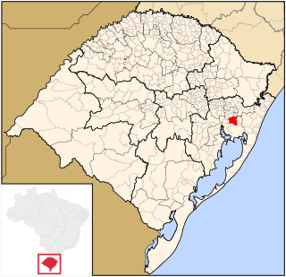
Santa Cruz do Sul is a city in central Rio Grande do Sul, Brazil. The city has an estimate 131,000 inhabitants as of 2020 and sits about 150 km from the capital city of the state, Porto Alegre. The city enjoys a high standard of living and gross income per capita is 2.5 times greater than that of the state of Rio Grande do Sul as a whole.

<span class="mw-page-title-main">Climate of Brazil</span> Overview of the climate of Brazil

The climate in Brazil varies considerably from mostly tropical north to temperate zones south of the Tropic of Capricorn.

<span class="mw-page-title-main">Porto Alegre Metro</span> Rapid transit system in Porto Alegre

The Porto Alegre Metro is a transit system operated jointly by the federal government, the state government of Rio Grande do Sul and the city of Porto Alegre through the company Trensurb in Brasil. It has 22 stations, totaling 43.8 kilometers (27.2 mi) of route, and carries about 175,000 users a day.

<span class="mw-page-title-main">Estância Velha</span> Municipality in Rio Grande do Sul, Brazil

Estância Velha is a municipality in the state of Rio Grande do Sul, Brazil. Its population was 51,292 inhabitants, according to 2021 IBGE data.

<span class="mw-page-title-main">Ivoti</span> Municipality in Rio Grande do Sul, Brazil

Ivoti is a municipality in the Brazilian state of Rio Grande do Sul, located in the Porto Alegre metropolitan area. The population is 24,690 in an area of 63.15 km2.

<span class="mw-page-title-main">Tietê Bus Terminal</span>

The Tietê Bus Terminal is the largest bus terminal in Latin America, and the second largest in the world, after the Port Authority Bus Terminal in New York City. The terminal is located in the Santana district in the city of São Paulo, Brazil. The official name in Portuguese is Terminal Rodoviário Governador Carvalho Pinto, named after Carlos Alberto Alves de Carvalho Pinto, a former Governor of the State of São Paulo.

<span class="mw-page-title-main">Bom Fim</span> Neighborhood in Porto Alegre, Brazil

Bom Fim is a neighborhood in the city of Porto Alegre, the state capital of Rio Grande do Sul in Brazil. It was created by the law number 2022 from December 7, 1959.

<span class="mw-page-title-main">BR-116 (Brazil highway)</span> Highway in Brazil

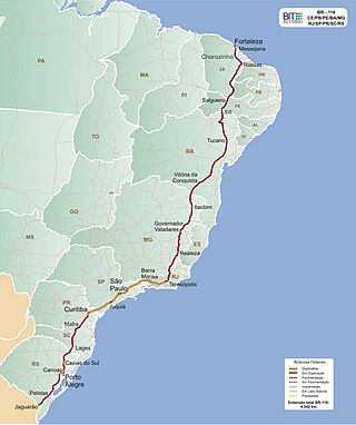
BR-116 is a federal route of highways of Brazil and the longest highway in the country, with 4,542 km (2,822 mi) of extension. The road connect Fortaleza, Ceará, one of the largest Northeast Brazil metropolises, to the southern city of Jaguarão, Rio Grande do Sul, in the border with Uruguay. It is also the longest highway in the country to be completely paved. It is considered one of the most important highways in the country, along with BR-101.

<span class="mw-page-title-main">Jacuí Delta</span> Brazilian hydrographic complex

The Jacuí Delta is a hydrographic complex of islands (archipelago), canals, swamps and ponds in Rio Grande do Sul, Brazil, formed by the meeting of the Jacuí, Caí, Sinos and Gravataí rivers, whose waters constitute Lake Guaíba.

References

  1. 1 2 "Panorama IBGE". Instituto Brasileiro de Geografia e Estatística (IBGE) (in Portuguese). Retrieved 11 October 2023.
  2. "Novo Hamburgo (RS) é reconhecida como a capital do calçado". Confederação Nacional de Municípios (CNM) (in Portuguese). Retrieved 11 October 2023.
  3. 1 2 "Pioneirismo". Prefeitura Municipal de Campo Bom (in Portuguese). Retrieved 11 October 2023.
  4. 1 2 3 "História de Campo Bom". Prefeitura Municipal de Campo Bom (in Portuguese). Retrieved 11 October 2023.
  5. "São Leopoldo's history". IBGE (in Portuguese). Retrieved 11 October 2023.
  6. "Banco de Dados Meteorológicos de INMET". Instituto Nacional de Meteorologia (INMET) (in Portuguese). Retrieved 11 October 2023.
  7. Raul Blos. "Uma história que se confunde com a história da própria cidade". Clube 15 de Novembro (in Portuguese). Retrieved 11 October 2023.
  8. "Bárbara Paz é uma das cidadãs ilustres de Campo Bom". Jornal Repercussão (in Portuguese). Retrieved 11 October 2023.
  9. "Normais Climatológicas Do Brasil 1981–2010" (in Portuguese). Instituto Nacional de Meteorologia. Retrieved 21 May 2024.