Vila Flores

Last updated
Vila Flores
Flowers Ville
Vila Flores.JPG
Vila Floresrsbandeira.png
Vila Floresrsbrasoes.jpg
Anthem: s:Hino do município de Vila Flores
RioGrandedoSul Municip VilaFlores.svg
Founded12 May 1988
Government
  MayorEvandro Antônio Brandalise [1] (MDB)
Area
  Total107.652 km2 (41.565 sq mi)
Population
[2]
  Total3,407
Demonym vilaflorense
Area code +55 54

Vila Flores is a municipality in the state of Rio Grande do Sul, Brazil. As of 2020, the estimated population was 3,396. [3]

Contents

History

Vila Flores was located along the path of the tropeiros who transported their cattle to Lagoa Vermelha, using an old pine tree that caught fire in a controlled burn as a reference point. The area was known as Pinheiro Seco. [4]

Around 1884, the chapel of Santo Antônio de Pádua emerged, along with the construction of some houses. Its intermediate position between Alfredo Chaves (now Veranópolis) and Capoeiras (now Nova Prata) allowed it to become a resting place for carters who passed through for rest and meals. [4]

On January 15, 1898, the Alfredo Chaves Colony separated from Lagoa Vermelha and was elevated to the status of a municipality, also encompassing Monte Vêneto (Cotiporã), Bela Vista (Fagundes Varela), Vista Alegre do Prata, Pinheiro Seco (Vila Flores), Nova Bassano, and Capoeiras (Nova Prata).

In 1920, Pinheiro Seco was renamed Vila Flores, in honor of the Fiori family, one of the first families to settle there, initiating various businesses.

The district was created with the name Vila Flores, by Municipal Law No. 240, of 09-30-1955, with territory separated from the district of Fagundes Varela, subordinate to the municipality of Veranópolis. Elevated to the status of a municipality with the name Vila Flores, by State Law No. 8,627, of 05-12-1988. [4]

Geography

It is located at a latitude of 28°51'46" south and a longitude of 51°32'00" west, at an altitude of 743 meters. Its population according to the 2010 census was 3,207 inhabitants. [4]

The relief is typical of the Upper Northeastern Slope Region, formed by a large number of hills and crossed by the Prata rivers in a north-south direction; by the Retiro stream in a northwest direction; and by the Jabuticaba stream in a north-south direction. The soil is a source of basalt, which serves as a means of economic production.

Sister cities

See also

Related Research Articles

<span class="mw-page-title-main">Afonso Cláudio, Espírito Santo</span> Municipality in Southeast, Brazil

Afonso Cláudio is a municipality in east central Espírito Santo, Brazil, founded in 1963. The town, at a height of 610m above sea level, has a population of approximately 30,455 and an area of 361.7 km2, and a population density of 32,53 inhabitants/km2. Its borders include: (E) Domingos Martins, Santa Maria de Jetibá and Itarana (N) Laranja da Terra and the neighbouring state of Minas Gerais, (W) Brejetuba (S) Conceição do Castelo and Venda Nova do Imigrante.

Talian, or Brazilian Venetian, is a dialect of the Venetian language, spoken primarily in the Serra Gaúcha region in the northeast of the state of Rio Grande do Sul in Brazil. It is also spoken in other parts of Rio Grande do Sul, as well as in parts of Espirito Santo and of Santa Catarina.

Lagoa may refer to the following:

<span class="mw-page-title-main">Aparecida de Goiânia</span> Place in Central-West, Brazil

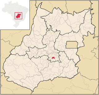
Aparecida de Goiânia is a city and municipality in central Goiás, Brazil. It is the second largest city in the state and the third largest industrial center, with a GDP of 11.980.984 billion reais in 2018.

<span class="mw-page-title-main">Serra Gaúcha</span> Mountain range and cultural region in Rio Grande do Sul, Brazil

The Serra Gaúcha is a cultural region comprising the mountainous areas in the northeastern portion of Rio Grande do Sul state in southern Brazil. Most of its inhabitants are of German and Italian ancestry. Consequently, the cities in the Serra Gaúcha reflect German and Italian influences through their architecture, gastronomy, and culture. Geographically, it is part of the Serra Geral mountain range.

<span class="mw-page-title-main">Cabeceiras</span> Municipality in Central-West, Brazil

Cabeceiras is a municipality in east-central Goiás state, Brazil. It is fast becoming a major producer of agricultural products using center pivot irrigation.

<span class="mw-page-title-main">Nova Prata</span> Place in Rio Grande do Sul, Brazil

Nova Prata is a municipality in the mountainous Serra Gaúcha region of Rio Grande do Sul, in southern Brazil. It is in the Guapore micro-region of the Nordeste Rio-Grandense meso-region of the state.

<span class="mw-page-title-main">Caçapava do Sul</span> Municipality in South, Brazil

Caçapava do Sul is a Brazilian municipality in the state of Rio Grande do Sul, located on the banks of the Camaquã River. As of 2020, the city has an estimated population of 33,548. It was the 2nd capital of the Piratini Republic from 1839 to 1840.

<span class="mw-page-title-main">Turuçu</span> Municipality in Rio Grande do Sul, Brazil

Turuçu is a Brazilian municipality in the southeastern part of the state of Rio Grande do Sul. It is nicknamed the National Capital of the Chili Pepper. The population is 3,423 in an area of 253.64 km². The name comes from a local Native American language. It lies close to the Lagoa dos Patos, a lagoon connected with the Atlantic Ocean.

<span class="mw-page-title-main">André da Rocha</span> Municipality in Rio Grande do Sul, Brazil

André da Rocha is a municipality in the state of Rio Grande do Sul, Brazil. It is surrounded by the municipalities Nova Prata, Protásio Alves, and Guabiju.

<span class="mw-page-title-main">Antônio Prado</span> Municipality in South, Brazil

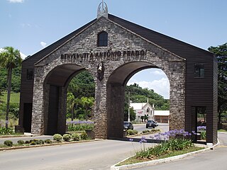
Antônio Prado is a municipality located in the Serra Gaúcha regionin The city is situated in the state of Rio Grande do Sul, Brazil. It boasts the largest collection of architectural heritage designated by IPHAN related to Italian colonization in Brazil. Its population is estimated at 13,041 people.

<span class="mw-page-title-main">Flores da Cunha</span> Place in South, Brazil

Flores da Cunha is a municipality in the state of Rio Grande do Sul, Brazil. It is the largest producer of wines inside Brazil. The Venetian language in its Brazilian form Talian is co-official with Portuguese in Flores da Cunha.

<span class="mw-page-title-main">Machadinho</span> Municipality in Rio Grande do Sul, Brazil

Machadinho is a municipality in the state of Rio Grande do Sul, Brazil. It was raised to municipality status in 1959, the area being taken out of the municipality of Lagoa Vermelha. As of 2020, the estimated population was 5,427.

Muitos Capões is a municipality in the state of Rio Grande do Sul, Brazil. It was raised to municipality status in 1992, the area being taken out of the municipalities of Vacaria, Lagoa Vermelha and Esmeralda. As of 2020, the estimated population was 3,173.

Nova Bassano is a municipality and a city in the state of Rio Grande do Sul, south Brazil.

Lagoa do Itaenga is a municipality located in the state of Pernambuco, Brazil. Located 78 km from Recife, capital of the state of Pernambuco. As of 2020, it has an estimated population of 21,460.

<span class="mw-page-title-main">Osasco</span> Municipality in Southeast, Brazil

Osasco is a municipality in São Paulo State, Brazil, located in the Greater São Paulo and ranking 5th in population among São Paulo municipalities. According to the IBGE 2015, Osasco currently has the 9th highest gross domestic product in Brazil, and the 2nd largest in the State of São Paulo. The population is 699,944 in an area of 64.95 km2. It is among the world's more dense cities, similar in density to Tokyo and New York City. It's considered the major urban centre of the Western portion of the Greater São Paulo. It used to be a district of São Paulo City until February 19, 1962, when Osasco became a municipality of its own. The city motto is "Urbs labor", a Latin phrase that means "City work".

<span class="mw-page-title-main">Microregion of Frederico Westphalen</span> Microregion in Rio Grande do Sul, Brazil

The Microregion of Frederico Westphalen was one of the Microregions of the Rio Grande do Sul state, in Brazil. It belonged to the mesoregion of the Noroeste Rio-Grandense. Its population was estimated by the IBGE to be of 175,391 in 2005, divided in 27 municipalities. Its total area is 5,182.529 km². The IBGE has since discontinued the microregion system for population tracking, replacing it with the term "immediate geographic region".
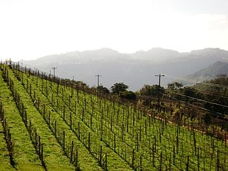
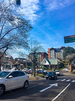
<span class="mw-page-title-main">Immediate Geographic Region of São João del-Rei</span> Urban administrative region in Minas Gerais, Brazil

The Immediate Geographic Region of São João del-Rei is one of the 10 immediate geographic regions in the Intermediate Geographic Region of Barbacena, one of the 70 immediate geographic regions in the Brazilian state of Minas Gerais and one of the 509 of Brazil, created by the National Institute of Geography and Statistics (IBGE) in 2017.

<span class="mw-page-title-main">Região da Uva e Vinho</span>

The Wine and Grape Region is a Brazilian tourist zone located in the northeast of the state of Rio Grande do Sul. It encompasses municipalities with the highest grape and wine production in the country. This condition has turned the region into one of the most important tourist hubs in Rio Grande do Sul, attracting hundreds of thousands of tourists from Rio Grande do Sul, other Brazilian states, and even other countries.

References

  1. Prefeito e vereadores de Vila Flores tomam posse; veja lista de eleitos em g1.globo.com
  2. "ESTIMATIVAS DA POPULAÇÃO RESIDENTE NO BRASIL E UNIDADES DA FEDERAÇÃO COM DATA DE REFERÊNCIA EM 1º DE JULHO DE 2021" (PDF). IBGE. 2021. Retrieved 12 May 2023.
  3. "Vila Flores". cidades.ibge.gov.br. Retrieved 2023-11-20.
  4. 1 2 3 4 "Historico Vila Flores". cidades.ibge.gov.br. Retrieved 2023-11-11.

28°54′S51°34′W / 28.900°S 51.567°W / -28.900; -51.567