
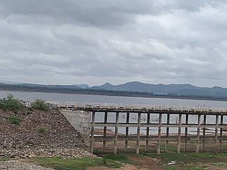
Karimnagar is a city and District Headquarters in the Indian state of Telangana. Karimnagar is a major urban agglomeration and fifth largest City in the state. It is governed by Municipal corporation and is the headquarters of the Karimnagar district It is situated on the banks of Manair River, which is a tributary of the Godavari River.It is the third largest and fastest growing urban settlement in the state, according to 2011 census. It has registered a population growth rate of 45.46% and 38.87% respectively over the past two decades between 1991 and 2011, which is highest growth rate among major cities of Telangana. It serves as a major educational and health hub for the northern districts of Telangana. It is a major business center and widely known for Granite and Agro-based industries. It is also called "City of Granites"

Nizamabad is a city in the Indian state of Telangana. Nizamabad is a major urban agglomeration and third largest city in the state. It is governed by municipal corporation and is the headquarters of the Nizamabad district. Although previously part of Hyderabad State and then Andhra Pradesh state, Nizamabad became a part of the newly formed state of Telangana by the Andhra Pradesh Reorganisation Act, 2014.

Adilabad is a city which serves as the headquarters of Adilabad district, in the Indian state of Telangana. Telugu, Marathi and Urdu are the native languages of Adilabad. Adilabad is famous for its rich cultivation of cotton. Hence, Adilabad is also referred as "White Gold City". It is located about 304 kilometres (189 mi) north of the state capital, Hyderabad, 150 kilometres (93 mi) from Nizamabad and 196 kilometres (122 mi) from Nagpur. Adilabad is called as the "Gateway to South India".

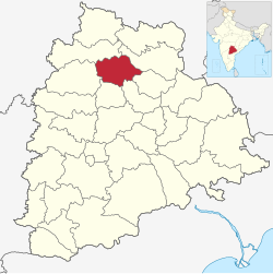
Karimnagar district is one of the 33 districts of the Indian state of Telangana. Karimnagar city is its administrative headquarters. The district shares boundaries with Peddapalli, Jagityal, Sircilla, Siddipet, Jangaon, Hanamkonda district and Jayashankar Bhupalapally districts.

Nizamabad district is a district located in the north-western region in the Indian state of Telangana. The city of Nizamabad is the district headquarters.The district share boundaries with Jagtial, Sircilla, Nirmal, Kamareddy districts and with Nanded district of the state boundary of Maharashtra.

Korutla municipality is second largest town and revenue division in the Jagtial district in the Indian state of Telangana. It is a historical town ruled by Jain Kings and second largest town in Jagtial district. It is the headquarters of Koratla constituency. It is located about 23 kilometres (14 mi) from the district headquarters Jagtial. It's 205 km. far from Hyderabad, 69 Km. far from Karimnagar and 76 Km. far from Nizamabad.

Nirmal is a town and the district headquarters of Nirmal district in the Indian state of Telangana. It is famed for its toys made out of wood.
Armoor is a Town in Armoor Mandal of Nizamabad district in the state of Telangana in India. Armoor is situated on NH 7 and NH 63 In earlier days named it as Navanathapuram since it has nine mountains around the Town. That is the reason it named as Armoor, .
Kammarpally is a village & mandal in the Nizamabad district in the state of Telangana in India. It is situated on National Highway 63.
Gollapally is a village located in Gollapalle mandal of Jagtial district in Telangana, India. Before the reorganisation of districts in Telangana, Gollapally was part of Karimnagar district.
Peddapalli is a town, Revenue Division in Peddapalli District in the Indian state of Telangana. It is the headquarters of the Peddapalli District and Peddapalli mandal also. It is located about 197 kilometres North of the state capital Hyderabad, 36 kilometres from Karimnagar, 28 kilometres from Ramagundam and also Peddapalli has railway junction named PDPL which connects PDPL - KRMR - NZB railway line and New Delhi (NDLS) - Chennai Central (MAS) railway line. There are two trains that terminate here. Karimnagar Tirupati express rail engine changes to electric engine here. As of 2011 census of India, Peddapalli has a population of 41,171. In 2016 due to population Increase, the civic body of Peddapalli was upgraded from Nagar Panchayat to Municipal council Post upgradation to Council.

National Highway 63, is a National Highway in India, total length 860 km (530 mi) that connects Nizamabad in Telangana and Jagdalpur in Chhattisgarh. It passes through the states of Telangana, Maharashtra and Chhattisgarh.

Adilabad district is a district located in the northern region of Telangana, India. It is known as the gateway district to South and Central India. The town of Adilabad is its headquarters. The district share boundaries with Asifabad, Nirmal districts and with the state boundary of Maharashtra.

The Northern Power Distribution Company of Telangana is the electricity distribution company owned by the government of Telangana for the seventeen northern districts of Telangana with Warangal as the headquarters.
Mancherial district is a district located in the northern region of the Indian state of Telangana. The district comprises 18 mandals and two revenue divisions – Mancherial and Bellampalli. The district headquarters is located at Mancherial town. It is surrounded by Komaram Bheem, Nirmal, Jagtial, Peddapalli and Bhupalpally districts of Telangana and with Maharashtra state.

Nirmal district is a district located in the northern region of the Indian state of Telangana. The district headquarters is located in the town of Nirmal. It borders the Telangana districts of Adilabad, Nizamabad, Mancherial, Asifabad, Jagtial districts as well as Nanded district of the state Maharashtra.

Kamareddy district is a district located in the northern region of the Indian state of Telangana. The district shares boundaries with Medak, Nizamabad, Sangareddy, Siddipet and Rajanna Sircilla districts and with the state boundary of Maharashtra and Karnataka.
Jayashankar Bhupalpally district is a district in the Indian state of Telangana. The district headquarters are located at Bhupalpally. It was a part of the erstwhile Warangal district and Karimnagar district prior to the re-organisation of districts in the state. The district share boundaries with Karimnagar, Mancherial, Peddapalli, Hanamkonda, Warangal, and Mulugu districts and with the state boundary of Maharashtra and Chhattisgarh.

Peddapalli district is a district located in the northern region of the Indian state of Telangana. Its Administrative Headquarters is at Peddapalli.The District Shares Boundaries with Mancherial, Karimnagar, Jagtial and Jayashankar Bhupalpally Districts.

Rajanna Sircilla district is a district in the Indian state of Telangana.Sircilla is the district headquarters. The district shares boundaries with Karimnagar, Siddipet, Jagtial, Kamareddy and Nizamabad districts.
