K’axob is an archaeological site of the Maya civilization located in Belize. It was occupied from about 800B.C. to A.D. 900.[1] The site is located in northern Belize in the wetlands of Pulltrouser Swamp in proximity to the Sibun River Valley in central Belize.[1] Research has shown that K’axob was occupied from the Late Preclassic Period to the Early Postclassic Period.[2] This period in time and the site is characterized by specific ceramic types as well as agriculture and an increase in social stratification. K’axob is a village site centered on two pyramid plazas and later grew in size during the Early Classic Period to the Late Classic Period.[1] The site includes a number of household, mounds and plazas. K’axob is mostly based on residential and household living but also has some ritualistic aspects. Many of the structures at the site show evidence of household dwellings as well as ritual purposes.[1] There are many burials at the site that illustrate the ritualistic aspects and social stratification at K’axob.[1] Many of the individuals, some more than others, were interned with beads made of shell as well as ceramic vessels, demonstrating this potential social stratification.[1] The pottery vessels recovered from the site demonstrates regularity in the production of pottery. The most prominent type of ceramic vessels recovered from the site were ‘serving bowls,’ with a tripodal base, and were present during the Early Classic Period.[3] There is also evidence of specialized areas for pottery production.[1] There are middens at the site that yielded a great deal of pottery sherds and are associated with structures that are believed to be kilns as well as with tools similar to modern pottery making tools.[1] There is also some evidence of stone tool production at the site.[1] The most common stone tool recovered from the site is a chert oval biface and is associated with agriculture and thought to have been used for weeding and hoeing.[1]
The Maya civilization was a Mesoamerican civilization developed by the Maya peoples, and noted for its logosyllabic script—the most sophisticated and highly developed writing system in pre-Columbian Americas—as well as for its art, architecture, mathematics, calendar, and astronomical system. The Maya civilization developed in an area that encompasses southeastern Mexico, all of Guatemala and Belize, and the western portions of Honduras and El Salvador. This region consists of the northern lowlands encompassing the Yucatán Peninsula, and the highlands of the Sierra Madre, running from the Mexican state of Chiapas, across southern Guatemala and onwards into El Salvador, and the southern lowlands of the Pacific littoral plain.
Belize is a country located on the eastern coast of Central America. Belize is bordered on the northwest by Mexico, on the east by the Caribbean Sea, and on the south and west by Guatemala. It has an area of 22,970 square kilometres (8,867 sq mi) and a population of 387,879 (2017). Its mainland is about 180 mi (290 km) long and 68 mi (110 km) wide. It has the lowest population and population density in Central America. The country's population growth rate of 1.87% per year (2015) is the second highest in the region and one of the highest in the Western Hemisphere.
A stone tool is, in the most general sense, any tool made either partially or entirely out of stone. Although stone tool-dependent societies and cultures still exist today, most stone tools are associated with prehistoric cultures that have become extinct. Archaeologists often study such prehistoric societies, and refer to the study of stone tools as lithic analysis. Ethnoarchaeology has been a valuable research field in order to further the understanding and cultural implications of stone tool use and manufacture.
Past and Current Archaeological Research at K’axob
K’axob was first excavated in 1979 and 1981 by B. L. Turner and Peter D. Harrison. The excavations were then taken over by Patricia A. McAnany in 1981, who is currently a professor at The University of North Carolina at Chapel Hill. The bulk of the research at the site was conducted from 1990-1998 and focused on social stratification, household structures and agriculture at K’axob.[1] Research at the site is ongoing through Boston University and is funded by The National Science Foundation.[1] Patricia A. McAnany continues to the primary investigator, with aid from graduate and undergraduate students and in collaboration with other universities and the Belize government.[1] Analysis is conducted both at the field lab at the site in Belize as well as at central lab at Boston University.[1]
Boston University is a private research university in Boston, Massachusetts. The university is nonsectarian, but has been historically affiliated with the United Methodist Church.
Architecture
Household and pyramidal architecture at K'axob went through multiple phases in response to increasing population and social complexity throughout the Preclassic and Classic periods. Most household complexes at K'axob were constructed on top of raised mounds or platforms; over 100 of these residential platforms exist at the site.[4] Some of the residential households were arranged in clusters of two or more structures surrounding a central patio area on basal platform mounds, while single mounds consisted of one residential structure.[5] Larger corporate households were occupied by 20-30 people, while smaller households held around 8 people [6] Differentiation between house sizes are an indication of a complex, stratified society. Structures were typically thatched with vegetation and made out of a plaster-like substance, using sascab as a fill for structural support, and flooring was generally composed of packed marl.[7] The main residential settlements, known as northern plaza A and southern plaza B, were situated around two central pyramid complexes.
A classic is an outstanding example of a particular style; something of lasting worth or with a timeless quality; of the first or highest quality, class, or rank – something that exemplifies its class. The word can be an adjective or a noun. It denotes a particular quality in art, architecture, literature, design, technology, or other cultural artifacts. In commerce, products are named 'classic' to denote a long-standing popular version or model, to distinguish it from a newer variety. Classic is used to describe many major, long-standing sporting events. Colloquially, an everyday occurrence may be described in some dialects of English as 'an absolute classic'.
Sascab is a naturally occurring mineral material described variously as "decomposed limestone", "breccia", and "the lime gravel mixture the Maya used as mortar." It has been used as a building and paving material in Mesoamerica since antiquity. In the context of pottery the term may also apply to mixtures of a more finely divided form of the same material.
Marl or marlstone is a calcium carbonate or lime-rich mud or mudstone which contains variable amounts of clays and silt. The dominant carbonate mineral in most marls is calcite, but other carbonate minerals such as aragonite, dolomite, and siderite may be present. Marl was originally an old term loosely applied to a variety of materials, most of which occur as loose, earthy deposits consisting chiefly of an intimate mixture of clay and calcium carbonate, formed under freshwater conditions; specifically an earthy substance containing 35–65% clay and 65–35% carbonate. It also describes a habit of coralline red alga. The term is today often used to describe indurated marine deposits and lacustrine (lake) sediments which more accurately should be named 'marlstone'. Marlstone is an indurated rock of about the same composition as marl, more correctly called an earthy or impure argillaceous limestone. It has a blocky subconchoidal fracture, and is less fissile than shale. The term 'marl' is widely used in English-language geology, while the terms Mergel and Seekreide are used in European references.
Northern Plaza A: The central pyramid located in the northern area of northern plaza A was constructed in the Late Classic period and was continuously maintained until its last phase of construction, which occurred in the Terminal Classic period. Standing at 13meters tall, this pyramid has since been heavily eroded and overgrown by vegetation.[8]
Southern Plaza B: The second settlement area, plaza B, is located 300meters south of plaza A and consists of four pyramidal structures in a ring formation, creating the central patio area within the complex. The largest pyramid in this complex, the Classic Period construction known as Structure 18, stands 4meters above the plaza floor. Several more “satellite” platforms, accommodating single and multiple dwellings, surround the outer region of the two main plazas.
Shifts in Architecture: Excavated stratigraphic layers of some plaza B platforms show that structures built in the Classic period were built on top of the remains of Late Preclassic structures, indicating that phases in construction took place over extended periods of time. Evidence for the earliest settlement of K'axob is present in the deepest excavated layer of the central basal platform at plaza B. The remains of these early structures date back to between 800 and 400BC.[9] By around 250BC, the village transformed substantially and buildings were frequently renovated, likely due to population growth.[10] Settlements began expanding from the core of plaza B to the outer regions where the satellite dwellings were constructed. At 200 to 50BC, building techniques transformed from oval dwellings built at ground level to rectangular buildings built on top of platforms, and singular dwellings were developed into multiple complexes within the plaza.[11] By the Terminal Preclassic, between 50BC and AD 250, previous architectural techniques were replaced by pyramidal structures which made up the focal points of the two main plazas, and residential compounds remained the featured architectural style throughout the Classic period up to AD 900.[12]Building Function: Evidence that suggests specific functional purposes for buildings is exemplified in some lightweight structures containing charcoal lined pits and middens, which were most likely used as kitchen areas. This type of building pattern, where lightweight structures were used for cooking and more extensive buildings were used as a household structure or an area for social events, is commonly found throughout contemporary Mesoamerican societies as well.[13] Several burials have also been found underneath the floors of these complexes, which appears to be another common practice of this society [14] The pyramidal structures likely acted as monuments in which ritualistic activities and ancestor worship took place.[8]
Major Features in K’axob
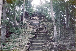
The tallest pyramid in K’axob reaches to a height of 13metres. It is located at the north end of northern Plaza A. The final phase of construction of this pyramid took place during the Terminal Classic Period. On the southern side of the plaza, there is a staircase constructed along the front of the pyramid. This was constructed during the Late Classic Period.
Other Features Found
A structure that was built on the west side of pyramidal structure 1 during the Terminal Classic Period was discovered during an excavation by Angela Lockard. A poorly preserved small raised platform was found here. This platform could have been used for ritual performances or oration. An excavation done by Kimberly Berry revealed the remains of a pottery kiln beneath a small rise at the north end of the site. This is one of the few pottery kilns excavated in the Maya lowlands.
Agriculture
Farming Techniques: The inhabitants of K'axob employed a farming technique called milpa, which involved the cutting and burning of high vegetation to clear forests and plant staple crops, usually maize, beans, and squash.[8] The cleared fields would then become rich in nutrients from the resulting ash for better crop production. Milpa farming is a type of crop rotation where crops can be grown in that field for a few seasons, and then must remain fallow for several years to conserve nutrients in the soil. This type of subsistence agriculture would have been sustainable for small populations, but as the village began expanding, other farming techniques would have been necessary as well.[8] Fields were maintained through hoeing and weeding, and the construction of canals and raised fields aided in irrigation.[15]
Diet:Radiocarbon bone analyses of individuals found in excavated burial pits revealed that the inhabitants of K'axob relied on a diet of crops such as maize, beans, and squash as well as tropical fruits and nuts. It is evident that they also likely ate dog, peccary, and deer as a source of protein.[16] The New River and surrounding wetland environment provided various freshwater resources such as turtle, fish, and species of mollusk.[17] Also present at the site are macrobotanical remains of avocado and cacao trees.[17]Botanical remains found within various households throughout the site indicate that people living in larger corporate households had access to a wider variety of foods in comparison to smaller households, suggesting evidence for social stratification.[18]
Burials
There were one-hundred and three individuals recovered from the site of K’axob and seventy-two burials.[19] The individuals recovered are male and female, of all ages, infant to adult.[20][21] Excavations yielded beads, pendants, including zoomorphic pendants as well as ceramics and unworked shells interned with the individuals.[20][21] Some of the burials held multiple individuals, while others were only single-person burials.[20][21] The individuals are also interned in different positions, ‘sitting’ or ‘flexed’.[20][21] Many of the burials are beneath household structures.[20][21] The burials at K’axob date from the Middle Preclassic Period through to the Terminal Classic Period.[20][21] The amount of beads, pendants or ceramics as well as the number of individuals and the position of an individual in a burial could suggest ritual practices as well as possible social stratification at K’axob.[20][21]
Burial 3: Adult burial, yielding pendants made from gastropod and bivalve shells, as well as beads with a uniform and regular shape, buried during the Late Formative.[23]
Burial 5: Adult male burial, yielding jade beads as well as an obsidian blade.[24]
Burial 7: Adult burial, yielding pendants made from gastropod and bivalve shells, as well as beads with a uniform and regular shape, from the late period [23]
Burial 19: Adult, female burial, from the Early Classic Period yielding irregularly shaped beads that were placed in a ‘carpet’ beneath the individual.[22] As well as ceramic vessels such as the Sierra Red Dish, this was characteristic of the time.[25]
Burial 23, 32 and 39: Individuals of undetermined sex, buried together, from the Late Preclassic Period, and interned with unfinished beads placed in a ‘carpet’ beneath the individuals.[26]
Burial 28: Adult burial, yielding irregularly shaped beads, and dates to the Middle Formative Period.[27]
Burial 30 A: Adult burial, yielding irregularly shaped beads and dates to the Middle Formative Period.[28]
Burial 41: Adult burial, interned with zoomorphic pendants.[29]
Burial 43: Adult male illustrating the cultural practice at K’axob of shells for ritual use; approximately 2,019 marine-shell beads were recovered from burial 43 in association with this individual.[28] Burial 43 yielded the largest number of beads recovered from a single burial, most of which were regularly shaped and uniform, implying that the individual was of higher status.[28] The burial dates to the Middle Preclassic Period.[28]
Human Modification of Beads at K’axob
Most beads (81%) were crafted from marine shell, Strombus sp [30] There were different kinds of beads also made from marine shell that are present in the K’axob site such as disks, pendants, figurines/blanks, ‘tinklers’ and ‘others’ [30] Aizpurúa and McAnany (1999) Research has shown that there is a greater presence of beads during the Middle Formative and the Late Formative [30] The beads from K’axob were retrieved primarily from burials as well as from shell middens, and some were retrieved from features such as households.[27] The shell remains that were recovered are predominantly from Caribbean resources, such as Strombus sp suggesting trade with the coast.[27]
Ceramics
The middle Formative ceramics in K’axob seem to be a combination of local lowland developments and external influences. They had links to El Salvador, the Gulf of Mexico and the Pacific Coast.[31] During this time, the external influences had a stronger influence on the ceramic tradition rather than the local ceramic materials.[31]
During the Late Middle Formative period, the ceramics that were created are identified by the Mamom ceramic sphere. The Late Formative period is identified as the Chicanel ceramic sphere. During the Formative period, Maya potteries were mostly red- slipped monochrome wares or unslipped smoothed vessel or rough surfaced vessels.[31] Vessel painting did not occur until the Classical period. In the Middle Formative period, some of the slipped vessels were decorated with resist pattern. This type of decoration is not seen in the Late Formative period.[31]
In the Late Formative period, ceramics and the surface treatment becomes more homogenous. During this period, the Sierra Red types of vessels are predominate vessel types. Most of the ceramics continued to be unslipped which makes it difficult to distinguish it from previous periods.[31]
Cross motif in potteries
A particular design that appears on K’axob potteries is the cross motif. This motif occurs only in the K’axob vessels. They have not been seen in any other Late Formative period villages.[32] This motif is important in pan-Mesoamerican symbols because it is associated with agricultural fields, the calendar, cardinal directions and seasonality.[32] The central point of the quadripartite had various meaning to it. For the inhabitants of K’axob it indicated a central focus point because it was the central place for its inhabitants.[32]
Altun Ha is the name given to the ruins of an ancient Mayan city in Belize, located in the Belize District about 50 kilometres (31 mi) north of Belize City and about 10 kilometres (6.2 mi) west of the shore of the Caribbean Sea. The site covers an area of about 8 square kilometres (3.1 sq mi).
Naachtun is an archaeological site of the pre-Columbian Maya civilization, situated at the northeastern perimeter of the Mirador Basin region in the southern Maya lowlands, now in the modern-day Department of El Petén, northern Guatemala. Naachtun was a major center of the region by the late Formative Period, and was one of the few Formative Period Mirador Basin centers which continued to flourish into the succeeding Classic period.
Nakbe is one of the largest early Maya archaeological sites. Nakbe is located in the Mirador Basin, in the Petén region of Guatemala, approximately 13 kilometers south of the largest Maya city of El Mirador. Excavations at Nakbe suggest that habitation began at the site during the Early Formative period and continued to be a large site until its collapse during the Terminal Formative period. The fall of Nakbe and El Mirador took place at roughly the same time.
Cerros is an Eastern Lowland Maya archaeological site in northern Belize that functioned from the Late Preclassic to the Postclassic period. The site reached its apogee during the Mesoamerican Late Preclassic and at its peak, it held a population of approximately 1,089 people. The site is strategically located on a peninsula at the mouth of the New River where it empties into Chetumal Bay on the Caribbean coast. As such, the site had access to and served as an intermediary link between the coastal trade route that circumnavigated the Yucatán Peninsula and inland communities. The inhabitants of Cerros constructed an extensive canal system and utilized raised-field agriculture.
Tamarindito is an archaeological site of the Maya civilization located along an escarpment in the Petén department of Guatemala. The city was the capital of the Petexbatún region of the southwestern Petén during the Early Classic period but was displaced by the newly founded conquest state of Dos Pilas. In the 8th century Tamarindito turned on its new overlord and defeated it. After the destruction of the Dos Pilas kingdom the region descended into chaos and suffered rapid population decline. The city was all but abandoned by the 9th century AD.
Topoxte is a pre-Columbian Maya archaeological site in the Petén Basin in northern Guatemala with a long occupational history dating as far back as the Middle Preclassic. As the capital of the Kowoj Maya, it was the largest of the few Postclassic Mesoamerican sites in the area. Topoxte is located on an island on Yaxha Lake across from the important Classic period center of Yaxha.
Yaxha is a Mesoamerican archaeological site in the northeast of the Petén Basin region, and a former ceremonial centre and city of the pre-Columbian Maya civilization. Yaxha was the third largest city in the region and experienced its maximum power during the Early Classic period.
Altar de Sacrificios is a ceremonial center and archaeological site of the pre-Columbian Maya civilization, situated near the confluence of the Pasión and Salinas Rivers, in the present-day department of Petén, Guatemala. Along with Seibal and Dos Pilas, Altar de Sacrificios is one of the better-known and most intensively-excavated sites in the region, although the site itself does not seem to have been a major political force in the Late Classic period.
El Tintal is a Maya archaeological site in the northern Petén region of Guatemala, about 25 kilometres (16 mi) northeast of the modern-day settlement of Carmelita, with settlement dating to the Preclassic and Classic periods. It is close to the better known sites of El Mirador, to which it was linked by causeway, and Nakbé. El Tintal is a sizeable site that includes some very large structures and it is one of the four largest sites in the northern Petén; it is the second largest site in the Mirador Basin, after El Mirador itself. El Tintal features monumental architecture dating to the Middle Preclassic similar to that found at El Mirador, Nakbé and Wakna. Potsherds recovered from the site date to the Late Preclassic and Early Classic periods, and construction continued at the site in the Late Classic period.
Xochitecatl[ʃot͡ʃiˈtekat͡ɬ] is a pre-Columbian archaeological site located in the Mexican State of Tlaxcala, 18 km southwest of Tlaxcala city. The major architecture dates to the Middle Preclassic Period but occupation continued, with one major interruption, until the Late Classic, when the site was abandoned, although there is evidence of ritual activity dating to the Postclassic and Colonial Periods. The ruins cover an area of 12 hectares on top of a volcanic dome.
El Chal is a pre-Columbian Maya archaeological site located in the upper San Juan River valley of the southeastern Petén Basin region, Guatemala. The site is situated approximately 30 kilometres (19 mi) to the north of the modern town of Dolores, near the contemporary village settlement of the same name, lying some 600 metres (2,000 ft) to the south.
Cuello is a Maya archaeological site in northern Belize. The site is that of a farming village with a long occupational history. It was originally dated to 2000 BC, but these dates have now been corrected and updated to around 1200 BC. Its inhabitants lived in pole-and-thatch houses that were built on top of low plaster-coated platforms. The site contains residential groups clustered around central patios. It also features the remains of a steam bath dating to approximately 900 BC, making it the oldest steam bath found to date in the Maya lowlands. Human burials have been associated with the residential structures; the oldest have no surviving burial relics, but from 900 BC onwards, they were accompanied by offerings of ceramic vessels.
Punta de Chimino is a Maya archaeological site in the Petexbatún region of the department of Petén in Guatemala. Occupation at the site dates to the Preclassic and Classic periods of Mesoamerican chronology. Punta de Chimino experienced a population surge in the Late Preclassic, followed by a reduction in occupation levels in the Early Classic and another increase in the Terminal Classic when the city became one of the few population centres to survive the political disintegration of the Petexbatún region after the collapse of the kingdom based at Dos Pilas. The neighbouring city of Seibal on the Pasión River appears to have intervened at Punta de Chimino at this time and to have politically dominated the smaller site.
The Preclassic period in Maya history stretches from the beginning of permanent village life c. 1000 BC. until the advent of the Classic Period c. 250 AD, and is subdivided into Early, Middle, and Late. Major archaeological sites of this period include Nakbe, Uaxactun, Seibal, San Bartolo, Cival, and El Mirador in Guatemala; Cahal Pech, Blackman Eddy, and Cerros in Belize; and Calakmul, Yaxnohcah, Ichkabal, Komchen, and Xocnaceh in Mexico.
Santa Rita is a Maya ruin and an archaeological reserve on the outskirts of Corozal, Belize. Historical evidence suggests that it was probably the ancient and important Maya city known as Chetumal.
The Mundo Perdido is the largest ceremonial complex dating from the Preclassic period at the ancient Maya city of Tikal, in the Petén Department of northern Guatemala. The complex was organised as a large E-Group astronomical complex consisting of a pyramid aligned with a platform to the east that supported three temples. The Mundo Perdido complex was rebuilt many times over the course of its history. By AD 250–300 its architectural style was influenced by the great metropolis of Teotihuacan in the Valley of Mexico, including the use of the talud-tablero form. During the Early Classic period the Mundo Perdido became one of the twin foci of the city, the other being the North Acropolis. From AD 250 to 378 it may have served as the royal necropolis. The Mundo Perdido complex was given its name by the archaeologists of the University of Pennsylvania.
The North Acropolis of the ancient Maya city of Tikal in Guatemala is an architectural complex that served as a royal necropolis and was a centre for funerary activity for over 1300 years. The acropolis is located near the centre of the city and is one of the most studied of Maya architectural complexes. Excavations were carried out from 1957 to 1969 by the University of Pennsylvania, directed by Edwin M. Shook and William Coe.
Pacbitun is a Maya archaeological site located near the town of San Ignacio, Belize, in the Cayo District of west central Belize. The modern Maya name given to the site means “stone set in earth”, likely a reference to multiple fragments of stone monuments. The site, at about 240 m above sea level, is one of the earliest known from the southern Maya Lowlands, and was inhabited for almost 2000 years, from ca. 900 BCE to 900 CE. Strategically, it straddles a territory of rolling, hilly terrain between the Mountain Pine Ridge and the tropical forest covered lowlands of the Upper Belize River Valley.
Caracol is the name given to a large ancient Maya archaeological site, located in what is now the Cayo District of Belize. It is situated approximately 40 kilometres south of Xunantunich and the town of San Ignacio Cayo, and 15 kilometers away from the Macal River. It rests on the Vaca Plateau at an elevation of 500 meters above sea-level, in the foothills of the Maya Mountains. Long thought to be a tertiary center, it is now known that the site was one of the most important regional political centers of the Maya Lowlands during the Classic Period. Caracol covered approximately 200 square kilometers, covering an area much larger than present-day Belize City and supported more than twice the modern city's population.
Santa Rita ruins is a Maya ruin and an archaeological reserve on the outskirts of Corozal, Belize. Historical evidence suggests that it was probably the ancient and important Maya city known as Chetumal.
References
Bartlett, Mary Lee; Neff, Hector (2000). "Differentiation of clay resources on a limestone plain: The analysis of clay utilization during the Maya Formative at K'axob Belize". Geoarchaeology. 15 (2): 95–133. doi:10.1002/(SICI)1520-6548(200002)15:2<95::AID-GEA1>3.0.CO;2-1.
Canuto, M.-A. & Yeager, j. (Eds) (2000). Archaeology of Communities: A New World Perspective. New York: Routledge. ISBN978-0-415-22278-5.CS1 maint: Multiple names: authors list (link) CS1 maint: Extra text: authors list (link)
Henderson, Hope (2003). "The organization of staple crop production at K'axob, Belize". Latin American Antiquity: 469–496.
Henderson, Hope (2003). "The organization of staple crop production at K'axob, Belize". Latin American Antiquity. 14 (4): 469–496. doi:10.2307/3557579. JSTOR3557579.
This page is based on this Wikipedia article Text is available under the CC BY-SA 4.0 license; additional terms may apply. Images, videos and audio are available under their respective licenses.