Related Research Articles
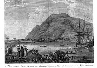
Three Saints Bay is a 9-mile (14-kilometer)-long inlet on the southeast side of Kodiak Island, Alaska, north of Sitkalidak Strait. It is 60 mi (97 km) southwest of Kodiak. The Three Saints Bay Site is an archaeological site, the location of the first Russian settlement in Alaska, Three Saints Harbor. The settlement was founded in 1784 by Grigory Shelikhov. The main settlement was moved in 1792 to Pavlovskaya Gavan, now known as the city of Kodiak. The Three Saints Bay Site was declared a National Historic Landmark by the United States in 1978.

Balclutha, also known as Star of Alaska, Pacific Queen, or Sailing Ship Balclutha, is a steel-hulled full-rigged ship that was built in 1886. She is representative of several different commercial ventures, including lumber, salmon, and grain. She is a U.S. National Historic Landmark and is currently preserved at the San Francisco Maritime National Historical Park in San Francisco, California. She was added to the National Register of Historic Places on 7 November 1976.

The Amalik Bay Archeological District is a geographic area with a significant number of archaeological sites in Alaska. It is located on the Pacific coast of Katmai National Park and Preserve, in the mainland portion of Kodiak Island Borough, Alaska.
Fort Durham, also known as Fort Taku, Taku, Taco, and Tacouw, is an archaeological site near Taku Harbor, Alaska, within the limits of Juneau City and Borough and Tongass National Forest. It was one of three Hudson's Bay Company (HBC) posts set up in Russian America. The Fort Durham Site was declared a U.S. National Historic Landmark in 1978.

Woody Island is located in Chiniak Bay, 2.6 miles (4.2 km) east of Kodiak, Alaska. It was originally settled by the native Alutiiq people who called themselves Tangirnarmiut, "the people of Tangirnaq." They inhabited and used Woody Island for thousands of years. The Russians established an agricultural colony on Woody Island in 1792. It was officially designated Wood Island in 1894 by the US Post Office and was the primary coastal settlement for commerce and trade for many years. The first road in Alaska was built on Woody Island. Aside from the Aleut presence, the island has gone through four periods of occupation by non-natives, and is largely unoccupied today. The island is approximately 2.8 miles long from north to south and 1.8 miles wide and 13 miles in circumference.

This is a list of the National Register of Historic Places listings in Aleutians West Census Area, Alaska.

This is a list of the National Register of Historic Places listings in Anchorage, Alaska.
This is a list of the National Register of Historic Places listings in Kodiak Island Borough, Alaska.

SS Aleutian was a passenger ship in North American coastal service. Built in 1899 for the Ward Line as SS Havana, she would later serve the building of the Panama Canal as SS Panama and ultimately enter Alaskan service as SS Aleutian.

The SS Northwestern, originally SS Oriziba, was a passenger and freight steamship launched in 1889 by the Delaware River Iron Ship Building and Engine Works, Chester, Pennsylvania which spent most of its career in service in the waters of the Territory of Alaska. The ship from early in its career had a reputation for trouble, and was frequently involved in groundings, collisions with other ships, and with port facilities. She first served as a transport in the West Indies as Oriziba, and was acquired by the Northwestern Steamship Company in 1906, sailed around Cape Horn, and renamed Northwestern. For the next thirty years she worked along the Alaska coast, transporting people, mail, and goods, as well as ore from mining operations at Kennecott.
The Kolmakov Redoubt Site is a historic archaeological site on the Kuskokwim River in western Alaska. The site is located downriver from the hamlet of Sleetmute, about 21 miles east of Aniak. The site was the location of a major trading post, which was one of the only ones established deep in the Alaskan interior by the Russian-American Company. The first site established by the Russians, in 1832, was little more than a log cabin near the confluence of the Kuskokwim with the Aniak River, and was known as Kolmakov's Townlet, after the trader Fedor Kolmakov. The success of this location prompted the construction in 1833 of an "odinochka" at the present location, near the confluence of the Kuskokwim and Kolmakof Rivers. At this site the Russians collected more than 1,400 beaver pelts in 1834, when their entire Alaska trade amounted to about 5,000. This facility was then upgraded to a "redoubt". The site was used until 1867, when American traders took over the fur trade following the Alaska Purchase.
The Russian Kiln Site is a historic archaeological site on Long Island, part of the Kodiak Archipelago of southern Alaska. It is one of the oldest industrial sites in Alaska, established by the Russian American Company for the production of bricks, an otherwise rare commodity in 19th-century Russian America. The kilns on the site were reported to produce between 3000 and 6000 bricks annually. Brick debris is scattered along the shore of Long Island in the area, which subsided after the 1964 Alaska earthquake and is subject to erosion. It is one of several sites in the vicinity of Kodiak Island where the Russians produced bricks.
The Middle Bay Brick Kiln is a historical archaeological site on Kodiak Island, Alaska. Located on an eroding bluff face on Middle Bay, the site contains the remains of a brickmaking facility established by the Russian American Company, probably in the early 19th century. The remains include a 4-by-4-metre Roman-style kiln, with a series of arches that supported the kiln floor and provided a space for the fire. At the time of the site's first major excavation in 1979, elements of at least one arch were in danger of being undermined by the eroding bluff face, and were removed for potential reconstruction by the Kodiak Historical Society. Other notable finds at the site include hand cut nails and a brick with Russian writing on it.
The Kaguyak Village Site, designated 49 Afg 4, is a historic and prehistoric archaeological site on the Pacific coast of the Alaska Peninsula in Katmai National Park and Preserve. It is the site of an Alaska Native village which was abandoned after the eruption of Novarupta in 1912. The historic elements of the site include the remains of a Russian Orthodox church and cemetery, as well as a number of frame house remnants and foundations.
Takli Island is an island off the southern coast of the Alaska Peninsula in the Shelikof Strait of southwestern Alaska. It is located at the mouth of Amalik Bay, off the mainland portion of Kodiak Island Borough, in Katmai National Park and Preserve. The area was first archaeologically investigated in the 1960s, when the prehistory of the area was little known, and the island's sites are type sites for a series of archaeological cultures.

The Kukak Village Site is a prehistoric and historic archaeological site, located on the shore of Kukak Bay, on the south coast of the Alaska Peninsula in Katmai National Park and Preserve. The area was documented to be occupied in the early 20th century, and was abandoned after the 1912 volcanic eruption of Novarupta. The Kukak Bay area is also of prehistoric significance, with researchers identifying 89 depressions as likely sites of subterranean houses, and a refuse midden.
KOD-171 is a prehistoric and historic archaeological site in the vicinity of Larsen Bay, a city on the north side of Kodiak Island in southern Alaska. The site was discovered by Smithsonian Institution archaeologist Aleš Hrdlička and described in 1944 as containing both historical Russian artifacts as well as prehistoric Kachemak Bay tradition artifacts. A 1978 survey team reported the site to include 22 house pits and an eroding shell midden. The site, listed on the National Register of Historic Places in 1981, is subject to erosion and vandalism by pot hunters.
Cape Alitak is a finger of land on the south side of Kodiak Island, the major island of the Kodiak Archipelago of southern Alaska. The cape is an extension of Tanner Head, from which it is separated by Rodman Reach, a saltwater lagoon. The cape is bounded on the east by Alitak Bay, on the west by the southern end of Shelikof Strait, and on the south by Sitkinak Strait, which separates Kodiak Island from the Trinity Islands. The cape has long been known its remarkable collection of prehistoric petroglyphs, which include a wide variety of shapes, some of animals and humans, and others of apparently abstract geometric figures. The cape was surveyed in detail in 2011 by archaeologists from the Alutiiq Museum in Kodiak, at which time thirteen different petroglyph locations were identified, along with evidence of prehistoric habitation of the area. The petroglyph site were listed on the National Register of Historic Places in 2013.

St. Michael Redoubt was a fortified trading and supply post established by the Russian-American Company in 1833, at the location of what is now the city of St. Michael, Alaska. It is located on the southern shore of Norton Sound at a convenient location near the mouth of the Yukon River. The fort, established by order of Ferdinand Wrangel, was used in following decades as a logistics point for exploration of southwestern Alaska and the Alaskan interior via the Yukon and other rivers.
The Savonoski River Archeological District encompasses a complex of prehistoric and historic archaeological sites on the Savonoski River near the mouth of the Grosvenor River in Katmai National Park and Preserve, located on the Alaska Peninsula of southwestern Alaska. At least two sites, designated 49-MK-3 and 49-MK-4 by state archaeologists, were identified when the site was listed in 1978. In 2003, the district was enlarge to include a third site, XMK-53. This area is believed to be the site of one of a group of Native Alaskan settlements referred to in Russian records as "Severnovsk". Excavations of a known prehistoric site in 1964 uncovered additional evidence of a post-contact settlement.
References
- ↑ Federal and state laws and practices restrict general public access to information regarding the specific location of this resource. In some cases, this is to protect archeological sites from vandalism, while in other cases it is restricted at the request of the owner. See: Knoerl, John; Miller, Diane; Shrimpton, Rebecca H. (1990), Guidelines for Restricting Information about Historic and Prehistoric Resources, National Register Bulletin, National Park Service, U.S. Department of the Interior, OCLC 20706997 .
- ↑ "National Register Information System". National Register of Historic Places . National Park Service. July 9, 2010.
