King City, Oregon

Last updated

King City, Oregon
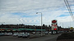
King City Oregon strip mall.JPG
Strip mall on 99W
Washington County Oregon Incorporated and Unincorporated areas King City Highlighted.svg
Location in Oregon
Usa edcp location map.svg
Red pog.svg
King City, Oregon
Location in the United States
Coordinates: 45°24′04″N122°48′25″W / 45.40111°N 122.80694°W / 45.40111; -122.80694
Country United States
State Oregon
County Washington
Incorporated 1966
Government
   Mayor Jaimie Fender[ citation needed ]
Area
[1]
  Total0.81 sq mi (2.10 km2)
  Land0.81 sq mi (2.10 km2)
  Water0.00 sq mi (0.00 km2)
Elevation
[2]
180 ft (50 m)
Population
 (2020) [3]
  Total5,184
  Density6,392.11/sq mi (2,467.36/km2)
Time zone UTC-8 (Pacific)
  Summer (DST) UTC-7 (Pacific)
ZIP code
97224
Area code(s) 503 and 971
FIPS code 41-39150 [4]
GNIS feature ID2411545 [2]
Website www.ci.king-city.or.us

King City is a city in Washington County, Oregon, United States. Its name was picked by the Tualatin Development Company, Inc., which used a royalty theme in naming the city streets. The population was 5,184 at the 2020 census. Fire protection and EMS services are provided through Tualatin Valley Fire and Rescue. [5]

Contents

History

The community was built by the Tualatin Development Company starting in 1964. [6] Created as a planned community for adults, King City was incorporated in March 1966. Build-out of the original 273 acres (110 ha) finished about 1978. [6] Originally, King City was developed as an age-restricted community governed by the rules of the King City Civic Association (KCCA) in which people under 50 could not live in the city. [7]

The KCCA rules were later changed to conform to the 1988 amendments to the Federal Fair Housing Act, which set the age restriction to 55 or older. Later, the city, which was at first contiguous with the boundaries of KCCA, expanded to include newer, non-age restricted developments. Future expansion to the west is planned for the city, within the limits of the Portland Metropolitan Urban Growth Boundary. In 2024, the City Council passed an annexation on the far West side of the King City Urban Growth Boundary. This annexation was approved by 100% of land owners and increased the City land area by approximately 215 acres.

Geography

According to the United States Census Bureau, the city has a total area of 0.72 square miles (1.86 km2), all of it land. [8]

Demographics

Historical population
CensusPop.Note
1970 1,427
1980 1,85329.9%
1990 2,06011.2%
2000 1,949−5.4%
2010 3,11159.6%
2020 5,18466.6%
U.S. Decennial Census [9] [3]

2010 census

As of the census of 2010, there were 3,111 people, 1,735 households, and 729 families living in the city. The population density was 4,320.8 inhabitants per square mile (1,668.3/km2). There were 1,920 housing units at an average density of 2,666.7 per square mile (1,029.6/km2). The racial makeup of the city was 89.0% White, 1.8% African American, 0.4% Native American, 5.2% Asian, 0.3% Pacific Islander, 1.3% from other races, and 2.1% from two or more races. Hispanic or Latino of any race were 4.5% of the population. [4]

There were 1,735 households, of which 12.0% had children under the age of 18 living with them, 34.2% were married couples living together, 6.2% had a female householder with no husband present, 1.6% had a male householder with no wife present, and 58.0% were non-families. 54.1% of all households were made up of individuals, and 43.7% had someone living alone who was 65 years of age or older. The average household size was 1.75 and the average family size was 2.63. [4]

The median age in the city was 63.9 years. 13% of residents were under the age of 18; 2.3% were between the ages of 18 and 24; 15.4% were from 25 to 44; 21.4% were from 45 to 64; and 48% were 65 years of age or older. The gender makeup of the city was 38.2% male and 61.8% female. [4]

2000 census

At the 2000 census, there were 1,949 people, 1,389 households and 480 families living in the city. The population density was 4,652.9 inhabitants per square mile (1,796.5/km2). There were 1,488 housing units at an average density of 3,552.4 per square mile (1,371.6/km2). The racial makeup of the city was 98.31% White, 0.15% Native American, 0.92% Asian, 0.10% from other races, and 0.51% from two or more races. Hispanic or Latino of any race were 0.51% of the population. [4]

There were 1,389 households, of which 0.6% had children under the age of 18 living with them, 31.4% were married couples living together, 2.9% had a female householder with no husband present, and 65.4% were non-families. 63.4% of all households were made up of individuals, and 55.2% had someone living alone who was 65 years of age or older. The average household size was 1.40 and the average family size was 2.09. [4]

Age distribution was 0.9% under the age of 18, 0.5% from 18 to 24, 3.0% from 25 to 44, 16.7% from 45 to 64, and 78.9% who were 65 years of age or older. The median age was 76 years. For every 100 females, there were 50.2 males. For every 100 females age 18 and over, there were 49.8 males. [4]

The median household income was $28,617, and the median family income was $49,444. Males had a median income of $39,917 versus $33,750 for females. The per capita income for the city was $27,536. None of the families and 2.4% of the population were living below the poverty line, including no persons under the age of 18 and 2.1% of those over 64. [4]

Related Research Articles

<span class="mw-page-title-main">Olivet, Michigan</span> City in Michigan, United States

Olivet is a city in Eaton County in the U.S. state of Michigan. The population was 1,605 at the 2010 census. University Of Olivet is located in the city.

<span class="mw-page-title-main">Unionville, Missouri</span> City in Missouri, United States

Unionville is a city in Putnam County, Missouri, United States. The population was 1,735 at the 2020 census. It is the county seat of Putnam County.

<span class="mw-page-title-main">Sunnyside, Clackamas County, Oregon</span> Unincorporated community in the state of Oregon, United States

Sunnyside is a former census-designated place in Clackamas County in the U.S. state of Oregon. Located in the Portland metropolitan area along Interstate 205, the population was 6,791 at the 2000 census. The area was not recorded as a distinct place for the 2010 census.

<span class="mw-page-title-main">Dunes City, Oregon</span> City in Oregon, United States

Dunes City is a city in Lane County, Oregon, United States. The population was 1,303 at the 2010 census.

<span class="mw-page-title-main">Banks, Oregon</span> City in Oregon, United States

Banks is a city in Washington County, Oregon, United States which is located in the Tualatin Valley. It is the southern anchor to the Banks–Vernonia State Trail, which is a 21-mile (34 km) long linear trail popular with bicyclists, hikers, and equestrians. The population was 1,777 at the 2010 census. The community was named for John and Nancy Banks, who owned a nearby dairy farm. Incorporated in 1921, it is located in the western part of the county where Oregon Route 6 intersects Oregon Route 47.

<span class="mw-page-title-main">Cornelius, Oregon</span> City in Oregon, United States

Cornelius is a city in Washington County, Oregon, United States. Located in the Portland metropolitan area, the city's population was 11,869 at the 2010 census. The city lies along Tualatin Valley Highway between Forest Grove to the west and Hillsboro to the east. Cornelius was incorporated in 1893 and is named for founder Thomas R. Cornelius.

<span class="mw-page-title-main">Durham, Oregon</span> City in Oregon, United States

Durham is a city in Washington County, Oregon, United States. Incorporated in 1966, the city is surrounded by Tigard and Tualatin and is adjacent to the Bridgeport Village shopping complex. The population was 1,351 at the 2010 census.

<span class="mw-page-title-main">Forest Grove, Oregon</span> City in Oregon, United States

Forest Grove is a city in Washington County, Oregon, United States, 25 miles (40 km) west of Portland. Originally a small farm town, it is now primarily a commuter town in the Portland metro area. Settled in the 1840s, the town was platted in 1850, then incorporated in 1872, making it the first city in Washington County. The population was 21,083 at the 2010 census, an increase of 19.1% over the 2000 figure (17,708).

<span class="mw-page-title-main">Garden Home–Whitford, Oregon</span> CDP in Oregon, United States

Garden Home-Whitford is a census-designated place (CDP) consisting of the neighborhoods of Garden Home and the smaller Whitford area in Washington County, Oregon, United States. They are located in the southwest hills of Portland, near Beaverton. As of the 2020 census, the CDP population was 7,081.

<span class="mw-page-title-main">Gaston, Oregon</span> City in Oregon, United States

Gaston is a city in Washington County, Oregon, United States. Located between Forest Grove to the north and Yamhill to the south, the city straddles Oregon Route 47 and borders the Tualatin River. Named after railroad executive Joseph Gaston, its population was 637 as of the 2010 census.

<span class="mw-page-title-main">Metzger, Oregon</span> Unincorporated community in the state of Oregon, United States

Metzger is a census-designated place and unincorporated community, in Washington County, Oregon, United States. As of the 2010 census, the CDP population was 3,765. It is named for Herman Metzger, who platted the community. It is a suburb located within Portland, Oregon.

<span class="mw-page-title-main">Raleigh Hills, Oregon</span> Unincorporated community in the state of Oregon, United States

Raleigh Hills is a census-designated place and neighborhood in Washington County, Oregon within the metropolitan area of Portland, Oregon, United States. It is located in the southwest hills in Washington County, with Beaverton to the west, West Slope to the north, and Progress and Garden Home to the south. As of the 2000 census, the census-designated place had a total population of 5,865.

<span class="mw-page-title-main">Rockcreek, Oregon</span> Unincorporated community in the state of Oregon, United States

Rockcreek is a census-designated place in Washington County, Oregon, United States, north of U.S. Route 26. It is named for the Rock Creek neighborhood in the area. As of the 2010 census, the CDP population was 9,316.

<span class="mw-page-title-main">Sherwood, Oregon</span> City in Oregon, United States

Sherwood is a city in Washington County, Oregon, United States. Located in the southeast corner of the county, it is a residential community in the Tualatin Valley, southwest of Portland. The population was 20,450 at the 2020 census. Sherwood was first incorporated in 1893 as a town. Originally named Smockville after its founder, James Christopher Smock, the town was given its current name by local businessman Robert Alexander in 1891. The name "Sherwood" may have come from Sherwood, Michigan or the Sherwood Forest in England.

<span class="mw-page-title-main">West Haven-Sylvan, Oregon</span> CDP in Oregon, United States

West Haven-Sylvan is a census-designated place (CDP) in Washington and Multnomah counties, Oregon, United States, north of U.S. Route 26. As of the 2020 census, the CDP population was 9,299.

<span class="mw-page-title-main">West Slope, Oregon</span> Unincorporated community in the state of Oregon, United States

West Slope is an unincorporated suburb of Portland, Oregon, United States and a census-designated place. It is in Washington County, to the west of Portland's West Hills neighborhood, to the northwest of Raleigh Hills and south of U.S. Route 26. Fire protection and EMS services are provided through Tualatin Valley Fire and Rescue.

<span class="mw-page-title-main">Springwater, Wisconsin</span> Town in Wisconsin, United States

Springwater is a town in Waushara County, Wisconsin, United States. The population was 1,389 at the 2000 census.

<span class="mw-page-title-main">Rivergrove, Oregon</span> City in Oregon, United States

Rivergrove is a city in Clackamas County, Oregon, United States. A small portion of the city extends into nearby Washington County. Its name is a portmanteau of the Tualatin River, which forms its southern border, and Lake Grove, a community that is now part of Lake Oswego. Interstate 5 forms the western border, with Childs Road serving as the northern border for much of the city. The population was 545 at the 2020 census.

<span class="mw-page-title-main">Tualatin, Oregon</span> City in Oregon, United States

Tualatin is a city located primarily in Washington County in the U.S. state of Oregon. A small portion of the city is also located in neighboring Clackamas County. It is a southwestern suburb in the Portland Metropolitan Area that is located south of Tigard. The population was 27,942 at the 2020 census.

<span class="mw-page-title-main">Barron, Wisconsin</span> City in Wisconsin, United States

Barron is a city in Barron County, in the U.S. state of Wisconsin. The population was 3,423 at the 2010 census. The city is surrounded by the Town of Barron.

References

  1. "ArcGIS REST Services Directory". United States Census Bureau. Retrieved October 12, 2022.
  2. 1 2 U.S. Geological Survey Geographic Names Information System: King City, Oregon
  3. 1 2 "Census Population API". United States Census Bureau. Retrieved October 12, 2022.
  4. 1 2 3 4 5 6 7 8 "U.S. Census website". United States Census Bureau . Retrieved December 21, 2012.
  5. "About TVF&R". Tualatin Valley Fire & Rescue. Retrieved March 13, 2014.
  6. 1 2 "Growth near end". The Oregonian . November 22, 1977. p. W7.
  7. Oliver, Gordon (November 9, 1976). "King City charts future". The Oregonian. p. B7W.
  8. "US Gazetteer files 2010". United States Census Bureau. Archived from the original on July 2, 2012. Retrieved December 21, 2012.
  9. "Census of Population and Housing". Census.gov. Retrieved June 4, 2015.