This article needs additional citations for verification .(January 2021) |
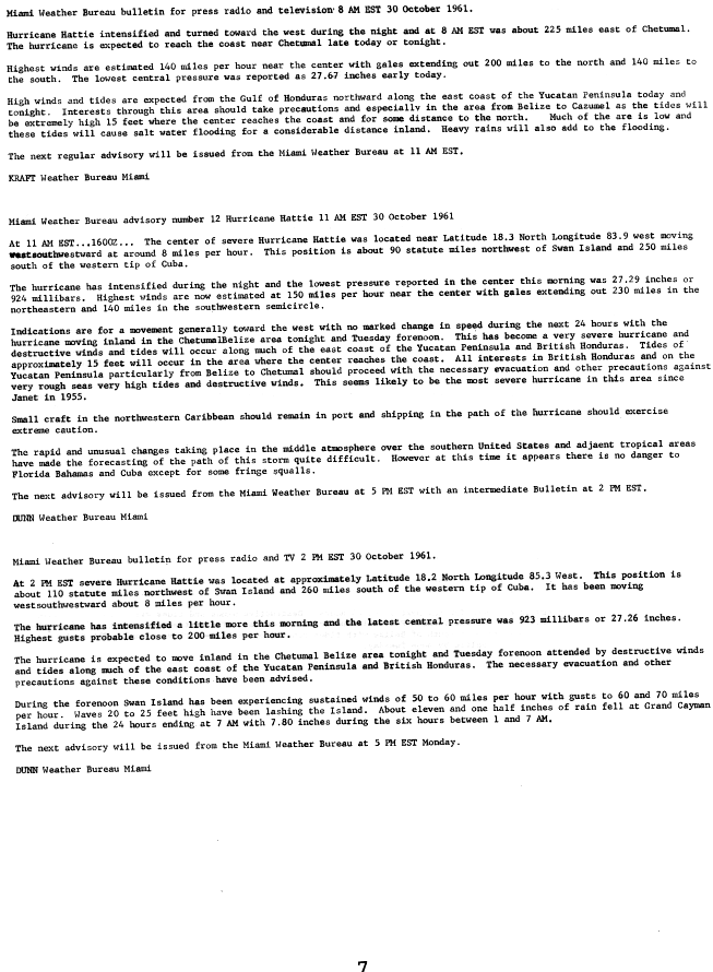
The List of Cayman Island hurricanes covers all hurricanes and tropical storms affecting the Cayman Islands from 1700 to 2021.
Month | Number of storms |
---|---|
May | 4 |
June | 8 |
July | 7 |
August | 34 |
September | 27 |
October | 39 |
November | 16 |
December | 1 |
Period | Number of storms |
---|---|
1700s | 5 |
1800s | 0 |
1810s | 1 |
1820s | 0 |
1830s | 2 |
1840s | 1 |
1850s | 2 |
1860s | 4 |
1870s | 8 |
1880s | 14 |
1890s | 12 |
Period | Number of storms |
---|---|
1900s | 10 |
1910s | 7 |
1920s | 12 |
1930s | 12 |
1940s | 8 |
1950s | 9 |
1960s | 6 |
1970s | 8 |
1980s | 6 |
1990s | 5 |
2000s | 20 |
2010s | 10 |
2020s | 15 |
Period | Number of storms |
---|---|
El Nino | 12 |
Neutral | 15 |
La Nina | 38 |
List of Atlantic tropical storms that caused fatalities in the Cayman Islands
Name | Year | Number of deaths |
---|---|---|
Unnamed | 1932 | 109 |
Ivan | 2004 | 2 |
Four | 1917 | 2 |
Two | 1915 | 1 |
Unnamed | 1785 | Many lives Num. Unknown |
List of Atlantic tropical storms and hurricanes that produced the highest amount of rainfall in the Cayman Islands
Precipitation | Storm | Location | Ref. | ||
---|---|---|---|---|---|
Rank | mm | in | |||
1 | 794.8 | 31.29 | Unnamed, 1944 | Grand Cayman Island | [44] |
2 | 577 | 22.72 | Alberto, 2006 | Owen Roberts International Airport | [45] |
3 | 552.2 | 21.74 | Isidore, 2002 | Cayman Brac | [46] |
4 | 451.4 | 17.77 | Paloma, 2008 | Cayman Brac | [47] |
5 | 312.9 | 12.32 | 1909 Monterrey hurricane | East End, Grand Cayman | [48] |
6 | 308.4 | 12.14 | Ivan, 2004 | Grand Cayman Island | [49] |
7 | 292.1 | 11.50 | Hattie, 1961 | Grand Cayman Island | [50] |
8 | 250.7 | 9.87 | Eta, 2020 | Owen Roberts International Airport | [51] |
9 | 229.1 | 9.02 | Nicole, 2010 | Owen Roberts International Airport | [52] |
10 | 193.0 | 7.60 | Grace, 2021 | Owen Roberts International Airport | [53] |
11 | 165.6 | 6.52 | Michelle, 2001 | Grand Cayman Island | [54] |
12 | 138.0 | 5.42 | Tropical Storm Frieda | Grand Cayman Island | [55] |
Hurricane Michelle was the fifth costliest tropical cyclone in Cuban history and the strongest hurricane of the 2001 Atlantic hurricane season. The thirteenth named storm and seventh hurricane that year, Michelle developed from a tropical wave that had traversed into the western Caribbean Sea on October 29; the wave had initially moved off the coast of Africa 13 days prior. In its early developmental stages, the depression meandered over Nicaragua, later paralleling the Mosquito Coast before intensifying into tropical storm intensity on November 1; Michelle was upgraded to hurricane strength the following day. Shortly after, rapid intensification ensued within favorable conditions, with the storm's central barometric pressure dropping 51 mbar in 29 hours. After a slight fluctuation in strength, Michelle reached its peak intensity as a Category 4 hurricane with winds of 140 mph (230 km/h) and a minimum pressure of 933 mbar. This tied Michelle with 1999's Lenny as the fourth most powerful November hurricane on record in the Atlantic Basin, behind only the 1932 Cuba hurricane and 2020 Hurricanes Iota and Eta. At roughly the same time, the hurricane began to accelerate northeastward; this brought the intense hurricane to a Cuban landfall within the Bay of Pigs later that day. Crossing over the island, Michelle was weakened significantly, and was only a Category 1 hurricane upon reentry into the Atlantic Ocean. The hurricane later transitioned into an extratropical cyclone over The Bahamas on November 5, before being absorbed by a cold front the following day.
The 1958 Atlantic hurricane season included every tropical cyclone either affecting or threatening land. There were ten named storms as well as one pre-season tropical storm. Seven of the storms became hurricanes, including five that were major hurricanes, or the equivalent of a Category 3 on the Saffir-Simpson scale. The strongest storm was Hurricane Helene, which became a strong Category 4 hurricane with 150 mph (240 km/h) winds and a barometric pressure of 930 millibars (27 inHg) while just offshore the southeastern United States.
The 1970 Atlantic hurricane season officially began on June 1 and lasted until November 30. These dates conventionally delimit the period of each year when most tropical cyclones form in the Atlantic basin. The season was fairly average, with 14 named storms forming, of which seven were hurricanes. Two of those seven became major hurricanes, which are Category 3 or higher on the Saffir–Simpson scale. Also, this was the first season in which reconnaissance aircraft flew into all four quadrants of a tropical cyclone.
The 1981 Atlantic hurricane season featured direct or indirect impacts from nearly all of its 12 tropical or subtropical storms. Overall, the season was fairly active, with 22 tropical depressions, 12 of which became a namable storm, while 7 of those reached hurricane status and 3 intensified into major hurricanes. The season officially began on June 1, 1981, and lasted until November 30, 1981. These dates conventionally delimit the period of each year when most tropical cyclones form in the Atlantic basin. However, tropical cyclogenesis can occur before these dates, as demonstrated with the development of two tropical depressions in April and Tropical Storm Arlene in May. At least one tropical cyclone formed in each month between April and November, with the final system, Subtropical Storm Three, becoming extratropical on November 17, 1981.
The 1951 Atlantic hurricane season was the first hurricane season in which tropical cyclones were officially named by the United States Weather Bureau. The season officially started on June 15, when the United States Weather Bureau began its daily monitoring for tropical cyclone activity; the season officially ended on November 15. It was the first year since 1937 in which no hurricanes made landfall on the United States; as Hurricane How was the only tropical storm to hit the nation, the season had the least tropical cyclone damage in the United States since the 1939 season. As in the 1950 season, names from the Joint Army/Navy Phonetic Alphabet were used to name storms this season.
The 1952 Atlantic hurricane season was the last Atlantic hurricane season in which tropical cyclones were named using the Joint Army/Navy Phonetic Alphabet. It was a near normal Atlantic hurricane season, although it was the least active since 1946. The season officially started on June 15; however, a pre-season unnamed storm formed on Groundhog Day, becoming the only storm on record in the month of February. The other six tropical cyclones were named using the Joint Army/Navy Phonetic Alphabet, the first of which formed on August 18. The final storm of the season dissipated on October 28, two and a half weeks before the season officially ended on November 15.
The 1945 Atlantic hurricane season produced multiple landfalling tropical cyclones. It officially began on June 16 and lasted until October 31, dates delimiting the period when a majority of storms were perceived to form in the Atlantic Ocean. A total of 11 systems were documented, including a late-season cyclone retroactively added a decade later. Five of the eleven systems intensified into hurricanes, and two further attained their peaks as major hurricanes. Activity began with the formation of a tropical storm in the Caribbean on June 20, which then made landfalls in Florida and North Carolina at hurricane intensity, causing one death and at least $75,000 in damage. In late August, a Category 3 hurricane on the modern-day Saffir–Simpson hurricane wind scale struck the Texas coastline, with 3 deaths and $20.1 million in damage. The most powerful hurricane of the season, reaching Category 4 intensity, wrought severe damage throughout the Bahamas and East Coast of the United States, namely Florida, in mid-September; 26 people were killed and damage reached $60 million. A hurricane moved ashore the coastline of Belize in early October, causing one death, while the final cyclone of the year resulted in 5 deaths and $2 million in damage across Cuba and the Bahamas two weeks later. Overall, 36 people were killed and damage reached at least $82.85 million.
The 1944 Atlantic hurricane season featured the first instance of upper-tropospheric observations from radiosonde – a telemetry device used to record weather data in the atmosphere – being incorporated into tropical cyclone track forecasting for a fully developed hurricane. The season officially began on June 15, 1944, and ended on November 15, 1944. These dates describe the period of each year when most tropical cyclones form in the Atlantic basin. The season's first cyclone developed on July 13, while the final system became an extratropical cyclone by November 13. The season was fairly active season, with 14 tropical storms, 8 hurricanes, and 3 major hurricanes. In real-time, forecasters at the Weather Bureau tracked eleven tropical storms, but later analysis uncovered evidence of three previously unclassified tropical storms.
The 1939 Atlantic hurricane season was the least active since 1930. The season had below normal activity, with only six tropical storms, of which three became hurricanes and one became a major hurricane, equivalent to Category 3 status or higher on the modern-day Saffir–Simpson scale. The first tropical cyclone formed on June 12, and the last dissipated on November 6. These dates are within the period of each year when most tropical cyclones form in the Atlantic basin.
The 1932 Atlantic hurricane season featured several powerful storms, including the Cuba hurricane, which remains the deadliest tropical cyclone in the history of Cuba and among the most intense to strike the island nation. It was a relatively active season, with fifteen known storms, six hurricanes, and four major hurricanes. However, tropical cyclones that did not approach populated areas or shipping lanes, especially if they were relatively weak and of short duration, may have remained undetected. Because technologies such as satellite monitoring were not available until the 1960s, historical data on tropical cyclones from this period are often not reliable. The Atlantic hurricane reanalysis project discovered four new tropical cyclones, all of which were tropical storms, that occurred during the year. Two storms attained Category 5 intensity, the first known occurrence in which multiple Category 5 hurricanes formed in the same year. The season's first cyclone developed on May 5, while the last remaining system transitioned into an extratropical cyclone by November 13.
The 1915 Atlantic hurricane season was an active Atlantic hurricane season in which six tropical storms developed. The first storm, which remained a tropical depression, appeared on April 29 near the Bahamas, while the final system, also a tropical depression, was absorbed by an extratropical cyclone well south of Newfoundland on October 22. Of the six tropical storms, five intensified into a hurricane, of which three further strengthened into a major hurricane. Four of the hurricanes made landfall in the United States. The early 20th century lacked modern forecasting and documentation, and thus, the hurricane database from these years may be incomplete.
The 1895 Atlantic hurricane season was a fairly inactive one, featuring only six known tropical cyclones, although each of them made landfall. Of those six systems, only two intensified a hurricane, while none of those strengthened into a major hurricane. However, in the absence of modern satellite and other remote-sensing technologies, only storms that affected populated land areas or encountered ships at sea were recorded, so the actual total could be higher. An undercount bias of zero to six tropical cyclones per year between 1851 and 1885 and zero to four per year between 1886 and 1910 has been estimated.
The 1890 Atlantic hurricane season was among the least active Atlantic hurricane seasons on record. The first tropical cyclone of the season was initially observed on May 27 and the last storm, Hurricane Four, dissipated over Central America on November 1. These dates fall within the period with the most tropical cyclone activity in the Atlantic. The first storm moved slowly north-northwestward, bringing heavy rains and extensive flooding to Cuba, which caused at least three fatalities and at least $1 million (1890 USD) in damage. It dissipated in the Gulf of Mexico on May 29. Tropical cyclogenesis went dormant for nearly two and a half months, until another system was observed near the Windward Islands on August 18. It traversed the Caribbean Sea and Gulf of Mexico, grazing the Yucatan Peninsula and making landfall in Louisiana before dissipating on August 28. Impact from the storm was minimal.
The 1887 Atlantic hurricane season was the most active Atlantic hurricane season on record at the time in terms of the number of known tropical storms that had formed, with 19. This total has since been equaled or surpassed multiple times. The 1887 season featured five off-season storms, with tropical activity occurring as early as May, and as late as December. It is also worthy of note that the volume of recorded activity was documented largely without the benefit of modern technology. Tropical cyclones during this era did not approach populated areas or shipping lanes, especially if they were relatively weak and of short duration, may have remained undetected. Because technologies such as satellite monitoring were not available until the 1960s, historical data on tropical cyclones from this period may not be comprehensive. An undercount bias of zero to six tropical cyclones per year between 1851 and 1885 and zero to four per year between 1886 and 1910 has been estimated. Of the known 1887 cyclones, Tropical Storm One and Tropical Storm Three were first documented in 1996 by Jose Fernandez-Partagas and Henry Diaz. They also proposed large alterations to the known tracks of several of the other 1887 storms. Later re-analysis led to the known duration of Hurricane Six, and also that of Hurricane Fifteen, being increased.
Tropical Storm Gilda in 1973 was the first documented tropical cyclone on record to transition into a subtropical cyclone. It formed on October 16 in the western Caribbean Sea from a tropical wave, and strengthened to reach peak winds of 70 mph (110 km/h) before striking Cuba. It later moved slowly through the Bahamas before weakening to tropical depression status. On October 24, with the assistance of a cold front off the coast of the eastern United States, Gilda transformed into a subtropical storm, becoming very large and strong. The storm later accelerated northeastward and became extratropical, ultimately dissipating near Greenland.
Hurricane Katrina was a late-forming tropical cyclone that impacted portions of the Greater Antilles and Bahamas in November 1981. The twenty-first tropical cyclone, eleventh named storm, and seventh hurricane of the 1981 Atlantic hurricane season, Katrina developed from an area of cloudiness in the western Caribbean Sea early on November 3. The initial tropical depression deepened slowly, and was upgraded to Tropical Storm Katrina on November 5. About six hours later, Katrina peaked with sustained winds of 85 mph (140 km/h). The storm made landfall along the south coast of Camagüey Province in Cuba early on November 6. Katrina quickly weakened to a tropical storm, before emerging into the Atlantic Ocean hours later. The system then accelerated northeastward and crossed the Bahamas late on November 6. Katrina dissipated late on November 7, shortly before merging with a frontal system.
The 1932 Cuba hurricane, known also as the Hurricane of Santa Cruz del Sur or the 1932 Camagüey hurricane, was the deadliest and one of the most intense tropical cyclones on record to have made landfall in Cuba. It is the only Category 5 Atlantic hurricane ever recorded in November. The cyclone had a path through the Caribbean Sea atypical to most hurricanes developing late in the Atlantic hurricane season. The storm's strong winds, storm surge, and rain devastated an extensive portion of central and eastern Cuba, where the storm was considered the worst natural disaster of the 20th century. Though the effects from the hurricane were concentrated primarily on Cuba, significant effects were also felt in the Cayman Islands and the Bahamas, with lesser effects felt elsewhere.
The 1924 Atlantic hurricane season featured the first officially recorded Category 5 hurricane, a tropical cyclone with maximum sustained winds exceeding 155 mph (249 km/h) on the modern-day Saffir–Simpson scale. The first system, Tropical Storm One, was first detected in the northwestern Caribbean Sea on June 18. The final system, an unnumbered tropical depression, dissipated on November 24. These dates fall within the period with the most tropical cyclone activity in the Atlantic. Of the 13 tropical cyclones of the season, six existed simultaneously. The season was average with 11 tropical storms, five of which strengthened into hurricanes. Further, two of those five intensified into major hurricanes, which are Category 3 or higher on the Saffir–Simpson scale.
Hurricane Paloma was a strong late-season Atlantic hurricane that set several records for its intensity and formation. It was the sixteenth tropical storm, eighth hurricane and fifth major hurricane of the 2008 Atlantic hurricane season. Paloma was, at the time, the third most powerful November hurricane on record in the Atlantic Basin, behind only the 1932 Cuba hurricane, 2020's hurricanes Iota and Eta, and a tie of 1999's Hurricane Lenny, and 2001's Hurricane Michelle. Paloma also marked the first time that at least one major hurricane formed in every month of the hurricane season from July to November, with only June not having a major hurricane in the season.
Hurricane Grace was the strongest tropical cyclone to make landfall in the Mexican state of Veracruz. Grace impacted much of the Leeward Islands and Greater Antilles as a tropical storm, before causing more substantial impacts in the Yucatán Peninsula and Veracruz as a hurricane. It was the seventh named storm, second hurricane, and first major hurricane of the 2021 Atlantic hurricane season. Originating from a tropical wave in the Main Development Region, the primitive system tracked west-northwest across the Atlantic Ocean towards the Antilles, becoming a tropical depression on August 14. It strengthened into Tropical Storm Grace later the same day, but weakened back to a depression due to an unfavorable environment. After moving near Haiti as a tropical depression, it strengthened back to a tropical storm and became a hurricane on August 18, reaching an initial peak intensity with maximum sustained winds of 80 mph (130 km/h) and a pressure of 986 mbar (29.12 inHg). It weakened back to a tropical storm after its landfall in the Yucatán Peninsula and emerged into the Bay of Campeche, entering a very favorable environment for intensification hours later. Grace then rapidly intensified into a Category 3 hurricane with winds of 120 mph (190 km/h) in about 24 hours. The storm made its final landfall in the state of Veracruz at peak intensity and quickly degenerated into a remnant low over mainland Mexico on August 21; however, its remnants later regenerated into Tropical Storm Marty in the Eastern Pacific on August 23.
{{cite report}}
: CS1 maint: multiple names: authors list (link)