
The City of Greater Geelong is a local government area in the Barwon South West region of Victoria, Australia, located in the western part of the state. It covers an area of 1,248 square kilometres (482 sq mi) and, had a population of 271,057 as of the 2021 Australian census. It is primarily urban with the vast majority of its population living in the Greater Geelong urban area, while other significant settlements within the LGA include Anakie, Balliang, Barwon Heads, Batesford, Ceres, Clifton Springs, Drysdale, Lara, Ocean Grove, Portarlington and St Leonards. It was formed in 1993 from the amalgamation of the Rural City of Bellarine, Shire of Corio, City of Geelong, City of Geelong West, City of Newtown, City of South Barwon, and parts of Shire of Barrabool and Shire of Bannockburn.
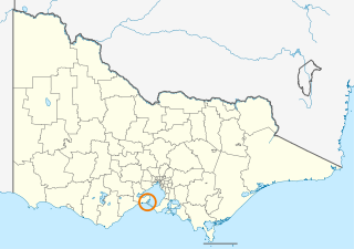
The Borough of Queenscliffe is a local government area in the Barwon South West region of Victoria, Australia, located in the southern part of the state. It is the smallest local government area in Victoria, covering an area of 10.83 square kilometres (4.18 sq mi) and, in June 2018, had a population of 2,982. It includes only two settlements, which are Queenscliff and Point Lonsdale. It is situated on the south coast, south-east of Geelong on the Bellarine Peninsula south of Swan Bay and next to the Port Phillip Heads, the entrance to Port Phillip Bay from Bass Strait.

Queenscliff is a small town on the Bellarine Peninsula in southern Victoria, Australia, south of Swan Bay at the entrance to Port Phillip. It is the administrative centre for the Borough of Queenscliffe. At the 2016 census, Queenscliff had a population of 1,315.
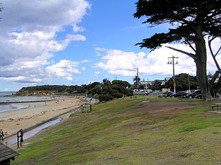
Point Lonsdale is a coastal township on the Bellarine Peninsula, near Queenscliff, Victoria, Australia. The town is divided between the Borough of Queenscliffe and the City of Greater Geelong. Point Lonsdale is also one of the headlands which, with Point Nepean, frame The Rip, the entrance to Port Phillip. The headland is dominated by the Point Lonsdale Lighthouse. At the 2016 census, Point Lonsdale had a population of 2,684. The population grows rapidly over the summer months through to the Easter period due to its popularity as a holiday destination.
The Victorian Heritage Register (VHR) lists places deemed to be of cultural heritage significance to the State of Victoria, Australia. It has statutory weight under the Heritage Act 2017. The Minister for Planning is the responsible Minister. Heritage Victoria was established as the State Government listing and permit authority in 1995, replacing the original authority, the Historic Buildings Preservation Council, established in 1974. Listing on the Victorian Heritage Register is separate from listing by a local Council or Shire, known as a Heritage Overlay. Heritage Victoria is currently part of the Department of Environment, Land, Water and Planning of the Government of Victoria, Australia. Heritage Victoria reports to the Heritage Council who approve recommendations to the Register and hear appeals when a registration is disputed. The council also hears appeals by an owner to a permit issued by Heritage Victoria. As of 2021, there are over 2,400 places and objects listed on the VHR.

The Rural City of Bellarine was a local government area southeast of the regional city of Geelong, Victoria, Australia, covering most of the Bellarine Peninsula. The Rural City covered an area of 331.78 square kilometres (128.1 sq mi), and from its origin as the Portarlington Road District, existed in a number of forms and under different names from 1853 until 1993.

Point Lonsdale Lighthouse, also known as the Point Lonsdale Signal Station, is close to the township of Point Lonsdale in the Borough of Queenscliffe, Victoria, Australia. It stands at the eastern end of the Bellarine Peninsula, on the western side of the entrance to Port Phillip from Bass Strait, on a headland overlooking the "Rip", a stretch of water considered one of the ten most treacherous navigable passages in the world, and the only seaborne approach to Melbourne. It is operated by Victorian Ports Corporation (Melbourne).
The Victorian Heritage Inventory, commonly known as the Heritage Inventory, is a list of all known historical archaeology sites in Victoria, Australia. It is maintained by Heritage Victoria , the Victorian State Government’s principal cultural (non-Indigenous) heritage agency.

Local government in the Australian state of Victoria consists of 79 local government areas (LGAs). Also referred to as municipalities, Victorian LGAs are classified as cities (34), shires (38), rural cities (6) and boroughs (1). In general, an urban or suburban LGA is called a city and is governed by a City Council, while a rural LGA covering a larger rural area is usually called a shire and is governed by a Shire Council. Local councils have the same administrative functions and similar political structures, regardless of their classification.

The Queenscliffe Maritime Museum is a regional maritime museum in the town of Queenscliff at the entrance from Bass Strait to the bay of Port Phillip in Victoria, south-eastern Australia. It lies within walking distance of the Searoad ferry terminal. It covers the maritime history of the Borough of Queenscliffe, southern Port Phillip and the connection with Bass Strait.

The Queenscliffe Historical Museum is a regional cultural history museum in the town of Queenscliff, Victoria, Australia. The museum is part of the Museum Accreditation Program (MAP).

The 2001 Victorian local elections were held on 17 March 2001 to elect the councils of 3 of the 78 local government areas in Victoria, Australia.


