List of places on the Victorian Heritage Register in the City of Brimbank

Last updated

This is a list of places on the Victorian Heritage Register in the City of Brimbank in Victoria, Australia. The Victorian Heritage Register is maintained by the Heritage Council of Victoria.

The Victorian Heritage Register, as of 2020, lists the following 13 state-registered places within the City of Brimbank: [1]

Place namePlace #LocationSuburb or TownCo-ordinatesBuiltState
registered
Photo
Albion Viaduct H1197 over the Maribyrnong River Keilor East and
Sunshine North
37°44′49″S144°50′47″E / 37.747020°S 144.846520°E / -37.747020; 144.846520 1927-2919 September 1996 Maribyrnong River viaduct bridge.jpg
Arundel Road Trestle Bridge H1952 over the Maribyrnong River Keilor 37°42′14″S144°49′58″E / 37.703910°S 144.832770°E / -37.703910; 144.832770 1906-0713 September 2001
Black Powder Mill H2029 Parklea Ave and
Grassy Point Rd
Cairnlea 37°45′49″S144°46′41″E / 37.763550°S 144.778040°E / -37.763550; 144.778040 193912 June 2003
H.V. McKay Memorial Gardens H1953 Anderson Rd Sunshine 37°47′01″S144°49′42″E / 37.783660°S 144.828280°E / -37.783660; 144.828280 190913 September 2001 Stone Gatepost, HV McKay Memorial Gardens, Sunshine.jpg
H.V. McKay Offices H1966 2 Devonshire Rd Sunshine 37°47′06″S144°49′51″E / 37.785083°S 144.830972°E / -37.785083; 144.830972 190921 March 2002
Iron Bridge H1427 over Maribyrnong River Keilor and Keilor East 37°43′26″S144°50′26″E / 37.723750°S 144.840444°E / -37.723750; 144.840444 186820 August 1982 Keilor Old Iron Bridge 007.JPG
John Darling and Son Flour Mill H0829 74 Sydney St Albion 37°46′40″S144°49′25″E / 37.777770°S 144.823730°E / -37.777770; 144.823730 192223 January 1991 John Darling & Son flour mill, Albion, Victoria.jpg
Keilor Hotel H1974 670-674 Old Calder Hwy Keilor 37°43′11″S144°50′11″E / 37.719700°S 144.836380°E / -37.719700; 144.836380 184814 February 2002 Keilor Hotel 006.JPG
Main Outfall Sewer H1932 Cypress Ave Brooklyn 37°49′18″S144°50′33″E / 37.821620°S 144.842470°E / -37.821620; 144.842470 1892-9413 September 2001
Massey Ferguson Complex H0667 Devonshire Rd, Hampshire Rd
and Harvester Rd
Sunshine 37°46′55″S144°49′52″E / 37.781960°S 144.831030°E / -37.781960; 144.831030 192710 February 1988
Overnewton H0200 51 Overnewton Rd Keilor 37°42′17″S144°49′15″E / 37.704840°S 144.820800°E / -37.704840; 144.820800 18499 October 1974 Keilor Overnewton Castle.JPG
Overnewton Gatehouse H1947 804-804A Old Calder Hwy Keilor 37°42′34″S144°49′13″E / 37.709420°S 144.820400°E / -37.709420; 144.820400 c. 185912 July 2001 Overnewton Gatehouse 001.JPG
Prefabricated Building H1971 152 Harrick Rd Keilor Park 37°43′14″S144°50′48″E / 37.720540°S 144.846750°E / -37.720540; 144.846750 c. 1850s14 February 2002

Related Research Articles

<span class="mw-page-title-main">City of Brimbank</span> Local government area in Victoria, Australia

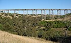
The City of Brimbank is a local government area located within the metropolitan area of Melbourne, Victoria, Australia. It comprises the western suburbs between 10 and 20 km west and northwest from the Melbourne city centre.

<span class="mw-page-title-main">Maribyrnong, Victoria</span> Suburb of Melbourne, Victoria, Australia

Maribyrnong is an inner-city suburb in Melbourne, Victoria, Australia, 8 km (5.0 mi) north-west of Melbourne's Central Business District, located within the City of Maribyrnong local government area. Maribyrnong recorded a population of 12,573 at the 2021 census.

<span class="mw-page-title-main">Sunshine railway station, Melbourne</span> Railway station in Melbourne, Australia

Sunshine railway station is located on the Sunbury line in Victoria, Australia. Originally named Braybrook Junction for the convergence of the major railways from central Melbourne to Ballarat and Bendigo, it was renamed when the suburb of Sunshine, which it serves, took its name from the nearby Sunshine Harvester Works. With the expansion of the railway network in Melbourne's west, Sunshine grew in importance, with cross-suburban goods routes constructed to Newport and from the adjacent Albion to Jacana line. From the mid-20th century, it became an interchange for the main interstate routes to South Australia and New South Wales, when the through line from Melbourne to Sydney was completed, although the main line to Adelaide was later diverted. In the early 21st century, the station was demolished and reconstructed to serve the diversion of the main passenger route to Geelong and beyond. It has been identified as a possible route for a future line to Melbourne Airport and as an interchange for the orbital Suburban Rail Loop.

<span class="mw-page-title-main">Natalie Suleyman</span> Australian politician

Natalie Suleyman is an Australian politician. She is a member of the Australian Labor Party, and is an elected member of the Victorian Legislative Assembly.

The Victorian Heritage Inventory, commonly known as the Heritage Inventory, is a list of all known historical archaeology sites in Victoria, Australia. It is maintained by Heritage Victoria , the Victorian State Government’s principal cultural (non-Indigenous) heritage agency.

<span class="mw-page-title-main">Sunshine Harvester Works</span>

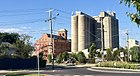
The Sunshine Harvester works was an Australian factory making agricultural equipment founded by industrialist H. V. McKay, and with engineering development headed by H.B. Garde.

<span class="mw-page-title-main">H.V. McKay Memorial Gardens</span>

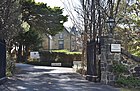
The H.V. McKay Memorial Gardens, originally the Sunshine Gardens, are a public space located in the Melbourne suburb of Sunshine, Victoria, Australia. Established in 1909, the Gardens are Australia's oldest remaining industrial garden and one of only two remaining in Australia, the heritage-listed gardens on Anderson Road were established by H.V. McKay as Sunshine Gardens later taken over by Brimbank City Council and renamed the H.V. McKay Memorial Gardens. The development of the gardens was not only an expression of H.V. McKay's own social philosophy but also represented a changing attitude to Urban Planning that is known as the "Garden Suburb" movement. A Friends Group was established in 2007 to rescue the Gardens from serious decline and in April 2012, local residents were campaigning to preserve the original state of the public space.

References

  1. "Brimbank". Victorian Heritage Database. Heritage Council of Victoria. Retrieved 6 April 2020.