
The City of Knox is a local government area in Victoria, Australia in the eastern suburbs of Melbourne. It has an area of 114 square kilometres (44.0 sq mi) and in 2020, Knox had a population of 165,147. This municipality is one of only a handful that survived the widespread municipal amalgamations that occurred in Victoria in the early 1990s.
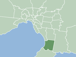
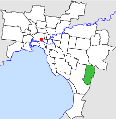
The City of Greater Dandenong is a local government area in Victoria, Australia in the southeastern suburbs of Melbourne. It has an area of just under 130 square kilometres and 166,094 residents in 2018. 29% of its land area forms part of the South East Green Wedge. It was formed in 1994 by the merger of parts of the former City of Dandenong and City of Springvale.

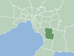
The City of Casey is a local government area in Victoria, Australia in the outer south-eastern suburbs of Melbourne. Casey is Victoria's most populous municipality, with a June 2018 population of 340,419. It has an area of 409 square kilometres (157.9 sq mi).
The City of Frankston is a local government area (LGA) in Victoria, Australia in the southern suburbs of Melbourne. It has an area of 130 square kilometres, and in June 2018, the City of Frankston recorded a population of 141,845.

St Kilda East is a suburb in Melbourne, Victoria, Australia, 6 km south-east of Melbourne's Central Business District, located within the Cities of Glen Eira and Port Phillip local government areas. St Kilda East recorded a population of 12,571 at the 2021 census.

Dandenong is a southeastern suburb of Melbourne, Victoria, Australia, about 35 km (22 mi) from the Melbourne CBD. It is the council seat of the City of Greater Dandenong local government area, with a recorded population of 30,127 at the 2021 census. Situated mainly on the northwest bank of the lower Dandenong Creek, it is 21.6 km (13.4 mi) from the eponymous Dandenong Ranges to its northeast and completely unrelated in both location and nature of the settlement.

Springvale is a suburb in Melbourne, Victoria, Australia, 22 km (14 mi) south-east of Melbourne's Central Business District, located within the City of Greater Dandenong local government area. Springvale recorded a population of 22,174 at the 2021 census.
The Victorian Heritage Register (VHR) lists places deemed to be of cultural heritage significance to the State of Victoria, Australia. It has statutory weight under the Heritage Act 2017. The Minister for Planning is the responsible Minister. Heritage Victoria was established as the State Government listing and permit authority in 1995, replacing the original authority, the Historic Buildings Preservation Council, established in 1974. Listing on the Victorian Heritage Register is separate from listing by a local Council or Shire, known as a Heritage Overlay. Heritage Victoria is currently part of the Department of Environment, Land, Water and Planning of the Government of Victoria, Australia. Heritage Victoria reports to the Heritage Council who approve recommendations to the Register and hear appeals when a registration is disputed. The council also hears appeals by an owner to a permit issued by Heritage Victoria. As of 2021, there are over 2,400 places and objects listed on the VHR.
The Dandenong Bypass is a highway in the state of Victoria, Australia that runs along the Dingley Freeway reservation from Springvale Road in Keysborough to the South Gippsland Highway in Dandenong South.
The City of Cranbourne was a local government area about 45 kilometres (28 mi) southeast of Melbourne, the state capital of Victoria, Australia. The city covered an area of 755 square kilometres (291.5 sq mi), and existed from 1860 until 1994. It was notable for being the last local government area to be declared a city prior to the large-scale amalgamations of 1994 – its former designation was the Shire of Cranbourne.

The City of Springvale was a local government area about 30 kilometres (19 mi) southeast of Melbourne, the state capital of Victoria, Australia. The city covered an area of 97.60 square kilometres (37.68 sq mi), and existed from 1857 until 1994.
The City of Dandenong was a local government area about 35 kilometres (22 mi) southeast of Melbourne, the state capital of Victoria, Australia. The city covered an area of 36.26 square kilometres (14.00 sq mi), and existed from 1857 until 1994.
The Bunurong Land Council Aboriginal Corporation is a Registered Aboriginal Party and incorporated association representing the Bunurong community in the state of Victoria, Australia, particularly in matters relating to the Victorian Aboriginal Heritage Act 2006.
