List of places on the Victorian Heritage Register in the City of Maribyrnong

Last updated

This is a list of places on the Victorian Heritage Register in the City of Maribyrnong in Victoria, Australia. The Victorian Heritage Register is maintained by the Heritage Council of Victoria.

The Victorian Heritage Register, as of 2020, lists the following 22 state-registered places within the City of Maribyrnong: [1]

Place namePlace #LocationSuburb or TownCo-ordinatesBuiltState
registered
Photo
Barkly Theatre H0878 277-287 Barkly St Footscray 37°47′58″S144°53′41″E / 37.799530°S 144.894740°E / -37.799530; 144.894740 191428 August 1991 Barkly Theatre (2018).jpg
CSR Sugar Refinery Complex H1311 265 Whitehall St Yarraville 37°49′09″S144°54′16″E / 37.819230°S 144.904490°E / -37.819230; 144.904490 1872-738 May 1997
Ercildoune H0494 66 Napier St Footscray 37°48′15″S144°54′07″E / 37.804110°S 144.901870°E / -37.804110; 144.901870 187626 August 1981 Ercildoune, Footscray (April 2020 1).jpg
ETA Foods Factory H1916 254 Ballarat Rd Braybrook 37°46′47″S144°51′33″E / 37.779860°S 144.859130°E / -37.779860; 144.859130 196131 May 2001 Image 3 ETA Foods Factory.jpg
Footscray Park H1220 4-68 Ballarat Rd Footscray 37°47′38″S144°54′20″E / 37.793850°S 144.905630°E / -37.793850; 144.905630 191121 November 1996 Footscray Park gates at dusk, Apr 2020.jpg
Footscray Primary School H1713 100 Geelong Road Footscray 37°47′54″S144°53′33″E / 37.798200°S 144.892600°E / -37.798200; 144.892600 186820 August 1982 Footscray Primary School (2018).jpg
Footscray railway station H1563 Irving and Hyde Sts Footscray 37°48′09″S144°54′05″E / 37.802450°S 144.901290°E / -37.802450; 144.901290 190020 August 1982 Footscray station signal box and footbridge.jpg
Footscray Town Hall H1218 61 Napier St Footscray 37°48′16″S144°54′02″E / 37.804500°S 144.900660°E / -37.804500; 144.900660 193621 November 1996 Footscray Town Hall, April 2020 (2).jpg
Henderson House H0183 43-45 Moreland St Footscray 37°48′11″S144°54′27″E / 37.803030°S 144.907600°E / -37.803030; 144.907600 1872-739 October 1974
Interlocking Railway Crossing Gates H1028 Anderson St Yarraville 37°48′59″S144°53′23″E / 37.816460°S 144.889680°E / -37.816460; 144.889680 189029 September 1994 Level crossing at Yarraville.jpg
Jack's Magazine H1154 off La Scala Ave Maribyrnong 37°46′54″S144°53′43″E / 37.781640°S 144.895380°E / -37.781640; 144.895380 1876-7818 April 1996 Jack's Magazine.jpg
Kariwara District Scout Headquarters H1343 4 Hyde St Footscray 37°48′13″S144°54′05″E / 37.803490°S 144.901460°E / -37.803490; 144.901460 1925-294 September 1997 Kariwara District Scout Headquarters, April 2020 (1).jpg
Kinnears Ropeworks H2067 124-188 Ballarat Rd Footscray 37°47′30″S144°53′33″E / 37.791720°S 144.892480°E / -37.791720; 144.892480 19093 March 2005 Kinnears Ropeworks Apr 2020 1.jpg
Maribyrnong Migrant Hostel H2190 61-71 Hampstead Rd Maidstone 37°46′34″S144°52′37″E / 37.775980°S 144.876990°E / -37.775980; 144.876990 194212 February 2009
Maribyrnong Tram Substation H2321 149A and 149B Raleigh Rd Maribyrnong 37°46′14″S144°53′05″E / 37.770620°S 144.884710°E / -37.770620; 144.884710 1941-4212 December 2013
Pipemakers Park Complex H1503 2 Van Ness Ave Maribyrnong 37°46′35″S144°53′40″E / 37.776250°S 144.894560°E / -37.776250; 144.894560 186820 August 1982
Royal Australian Field Artillery Barracks H1098 Wests Rd,
Ordnance Reserve
and Waterford Ave
Maribyrnong 37°46′24″S144°52′51″E / 37.773210°S 144.880840°E / -37.773210; 144.880840 19115 October 1995
Saltwater River Crossing Site and Footscray Wharves Precinct H1397 west bank of the Maribyrnong River Footscray 37°48′05″S144°54′30″E / 37.801360°S 144.908410°E / -37.801360; 144.908410 1800s11 December 1997
Saltwater River Rail Bridge H1213 over the Maribyrnong River Footscray and
West Melbourne
37°47′54″S144°54′58″E / 37.798200°S 144.916210°E / -37.798200; 144.916210 1858-5924 October 1996 Saltwater River rail bridge.jpg
State Savings Bank Building H0723 13 Ballarat St Yarraville 37°48′59″S144°53′28″E / 37.816350°S 144.891200°E / -37.816350; 144.891200 190922 February 1989
Sun Theatre H0679 6-12 Ballarat St Footscray 37°48′58″S144°53′27″E / 37.816000°S 144.890700°E / -37.816000; 144.890700 193823 December 1987 Sun theatre Yarraville - 6107104667.jpg
The Pebbles H1308 57A Droop St Footscray 37°47′47″S144°53′47″E / 37.796360°S 144.896390°E / -37.796360; 144.896390 192016 October 1997 The Pebbles 1.jpg

Related Research Articles

<span class="mw-page-title-main">City of Maribyrnong</span> Local government area in Victoria, Australia

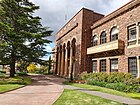
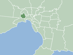
The City of Maribyrnong is a local government area within the metropolitan area of Melbourne, Australia. It comprises the inner western suburbs between 5 and 10 kilometres from Melbourne city centre. It was formed in 1994 from the merger of the City of Footscray and parts of the City of Sunshine. In June 2018, Maribyrnong had a population of 91,387.

<span class="mw-page-title-main">Maribyrnong, Victoria</span> Suburb of Melbourne, Victoria, Australia

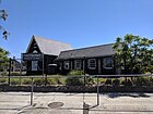
Maribyrnong is an inner-city suburb in Melbourne, Victoria, Australia, 8 km (5.0 mi) north-west of Melbourne's Central Business District, located within the City of Maribyrnong local government area. Maribyrnong recorded a population of 12,573 at the 2021 census.

<span class="mw-page-title-main">Footscray, Victoria</span> Suburb of Melbourne, Victoria, Australia

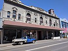
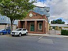
Footscray is an inner-city suburb in Melbourne, Victoria, Australia, 5 km (3.1 mi) west of Melbourne's Central Business District, located within the City of Maribyrnong local government area and its council seat. Footscray recorded a population of 17,131 at the 2021 census.

<span class="mw-page-title-main">Footscray Park</span> Park in Footscray, Melbourne, Victoria, Australia

Footscray Park is one of the largest and most intact examples of an Edwardian park in Australia. The 15-hectare park is located on the south bank of the Maribyrnong River in Footscray in Victoria. It is classified as a heritage place on the Victorian Heritage Register for its aesthetic, horticultural and social significance to the State of Victoria and was the first gardens to be placed on the register. The park is noted for its botanical collection, ornamental ponds and garden structures.

<span class="mw-page-title-main">Albion Viaduct</span> Bridge

The Maribyrnong River Viaduct carries the Albion–Jacana railway line across the Maribyrnong River in the western suburbs of Melbourne, Australia. It is located near the E J Whitten Bridge, and is almost 400 metres long.

<span class="mw-page-title-main">Jack's Magazine</span>

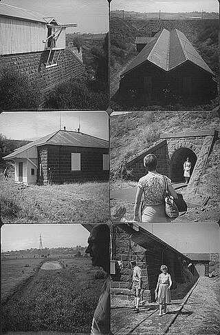
Jack's Magazine is located on the Maribyrnong River at Maribyrnong, Victoria. The complex opened in 1878, to provide safe storage for bonded gunpowder and explosives imported into the colony of Victoria. The twin bluestone vaulted buildings are concealed behind high earth mound blast walls, and a tall bluestone wall, with a canal connecting it to the river. It was designed by government architect, William Wardell, Inspector General, Public Works Department and built by contractor George Cornwell.

CSR Yarraville is an operating sugar refinery at Whitehall Street, Yarraville, City of Maribyrnong, Victoria, Australia. It was built from 1872 to 1980s. It is also known as Colonial Sugar Refining Company Refinery of Yarraville. It was added to the Victorian Heritage Register on 21 October 1992.

<span class="mw-page-title-main">Victorian Socialists</span> Political party in Australia

The Victorian Socialists (VS) is a political party based in the Australian state of Victoria.

References

  1. "Maribyrnong City". Victorian Heritage Database. Heritage Council of Victoria. Retrieved 6 April 2020.