
Colac is a small city in the Western District of Victoria, Australia, approximately 150 kilometres south-west of Melbourne on the southern shore of Lake Colac.

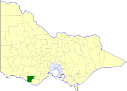
The Shire of Colac Otway is a local government area in the Barwon South West region of Victoria, Australia, located in the south-western part of the state. It covers an area of 3,438 square kilometres (1,327 sq mi) and in June 2018 had a population of 21,503. It includes the towns of Apollo Bay, Beeac, Beech Forest, Birregurra, Colac, Cressy, Forrest, Johanna, Kennett River, Lavers Hill, Warrion and Wye River. It came into existence on 23 September 1994 through the amalgamation of the local government areas of City of Colac, Shire of Colac, part of the Shire of Otway and part of the Shire of Heytesbury.
Lorne is a seaside town on Louttit Bay in Victoria, Australia. It is situated about the Erskine River and is a popular destination on the Great Ocean Road tourist route. Lorne is in the Surf Coast Shire and at the 2016 census had a population of 1,114 but this figure grows during the holiday season.

Apollo Bay is a coastal town in southwestern Victoria, Australia. It is situated on the eastern side of Cape Otway, along the edge of the Barham River and on the Great Ocean Road, in the Colac Otway Shire. The town had a population of 1,790 at the 2021 census.

Winchelsea is a town in Victoria, Australia. The town is located in the Surf Coast Shire local government area, the suburb or locality of Winchelsea is predominantly within Surf Coast Shire with a small section within the Colac Otway Shire. Winchelsea is located on the Barwon River 115 km south-west of Melbourne and close to Geelong.

Birregurra, is a town in Colac Otway Shire, Victoria, Australia, approximately 130 kilometres (81 mi) south-west of Melbourne. At the 2016 census, it had a population of 828.

Colac railway station is located on the Warrnambool line in Victoria, Australia. It serves the town of Colac, and opened on 27 July 1877.
Cape Otway is a cape and a bounded locality of the Colac Otway Shire in southern Victoria, Australia on the Great Ocean Road; much of the area is enclosed in the Great Otway National Park.

The Shire of Colac was a local government area about 150 kilometres (93 mi) west-southwest of Melbourne, the state capital of Victoria, Australia. The shire covered an area of 1,458.2 square kilometres (563.0 sq mi), and existed from 1859 until 1994.
The Shire of Heytesbury was a local government area about 200 kilometres (124 mi) west-southwest of Melbourne, the state capital of Victoria, Australia. The shire covered an area of 1,558.39 square kilometres (601.7 sq mi), and existed from 1895 until 1994.

The Shire of Otway was a local government area about 190 kilometres (118 mi) southwest of Melbourne, the state capital of Victoria, Australia. The shire covered an area of 1,906.94 square kilometres (736.3 sq mi), and existed from 1919 until 1994.

The City of Colac was a local government area about 150 kilometres (93 mi) west-southwest of Melbourne, the state capital of Victoria, Australia. The city covered an area of 10.88 square kilometres (4.2 sq mi), and existed from 1938 until 1994. Its area was surrounded by the separate and largely rural Shire of Colac.
Gellibrand is a town in south west Victoria, Australia. The town is located in the Otway Ranges midway between the Princes Highway and Great Ocean Road in the Colac Otway Shire, 176 kilometres (109 mi) south west of the state capital, Melbourne. At the 2016 census, Gellibrand had a population of 210. Gellibrand is home to the Otway Districts Demons Football and Netball Club, who play Australian Rules Football and participate in the Colac & District Football League.
Ombersley is a rural locality in Victoria, Australia. Most of the locality is in Colac Otway Shire, with a portion being in adjacent Surf Coast Shire. In the 2016 census, Ombersley had a population of 97.
Benwerrin is a rural locality in the Surf Coast Shire, Victoria, Australia.
The Forrest railway line is a former branch railway in Victoria, Australia. It branched off the Warrnambool railway line at Birregurra, and ran through the foothills of the Otway Ranges to the town of Forrest.
Norman Houghton is a historian and archivist in Geelong, Victoria, who has published more than 40 books, many focusing on timber tramways and sawmills of the Otway and Wombat Forests of Western Victoria, Australia. Most of his works have been self-published, while he has provided numerous articles to the newsletter and journal of the Light Railway Research Society of Australia.
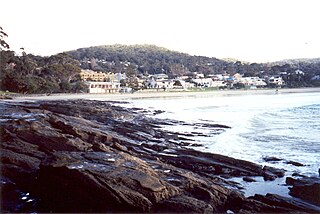
Skenes Creek is a rural locality in Victoria, Australia, situated in the Shire of Colac Otway. In the 2016 census, Skenes Creek had a population of 164.
Joe McCracken is an Australian politician. He has been a member of the Victorian Legislative Council since November 2022, representing Western Victoria. McCracken is a member of the Liberal Party. McCracken is openly gay.
The Restore Democracy Sack Dan Andrews Party, also known as Sack Dan Andrews Restore Democracy, was an Australian political party founded in 2022 by Tosh-Jake Finnigan, an openly transgender whistleblower over the Labor Party's so-called 'red shirts rorts' scandal. The party was formed in opposition to then-Victorian Premier Daniel Andrews.

