
The City of Whittlesea is a local government area located in the outer northern suburbs of Melbourne, the state capital of Victoria, Australia. The city covers an area of 490 square kilometres (189.2 sq mi), and in June 2018, it had a population of 223,322.

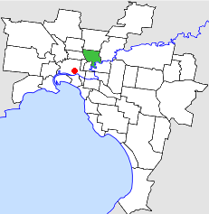
The City of Darebin is a local government area in Victoria, Australia, in the northern suburbs of Melbourne. It has an area of 54 square kilometres (20.8 sq mi) and in June 2018 Darebin had a population of 161,609. Municipal offices are located at 350 High Street, Preston.

The City of Banyule is a local government area in Victoria, Australia in the north-eastern suburbs of Melbourne. It was created under the Local Government Act 1989 and established in 1994 as an amalgamation of former councils. It has an area of 63 square kilometres (24.3 sq mi) and lies between 7 and 21 km from central Melbourne. In 1994 it had a population of 116,000. In June 2018 Banyule had a population of 130,237. The Yarra River runs along the City's southern border while its western border is defined by Darebin Creek.

Alphington is a suburb in Melbourne, Victoria, Australia, 7 km (4.3 mi) north-east of Melbourne's Central Business District, located within the Cities of Darebin and Yarra local government areas. Alphington recorded a population of 5,702 at the 2021 census.

Northcote is an inner-city suburb in Melbourne, Victoria, Australia, 7 km (4.3 mi) north-east of Melbourne's Central Business District, located within the City of Darebin local government area. Northcote recorded a population of 25,276 at the 2021 census.

Preston is a suburb in Melbourne, Victoria, Australia, 9 km (5.6 mi) north-east of Melbourne's central business district, located within the City of Darebin local government area. Preston recorded a population of 33,790 at the 2021 census.

Reservoir ( "REZ-ə-vore") is a suburb in Melbourne, Victoria, Australia, 12 km (7.5 mi) north of Melbourne's Central Business District, located within the City of Darebin local government area. Reservoir recorded a population of 51,096 at the 2021 census.

Thornbury is an inner-city suburb in Melbourne, Victoria, Australia, 7 km (4.3 mi) north-east of Melbourne's Central Business District, located within the City of Darebin local government area. Thornbury recorded a population of 19,005 at the 2021 census.

Ivanhoe is a suburb of Melbourne, Victoria, Australia, 9 kilometres (5.6 mi) north-east of Melbourne's Central Business District, located within the City of Banyule local government area. Ivanhoe recorded a population of 13,374 at the 2021 census.
The City of Northcote was a local government area about 5 kilometres (3 mi) northeast of Melbourne, the state capital of Victoria, Australia. The city covered an area of 17.62 square kilometres (6.80 sq mi), and existed from 1883 until 1994.

The City of Preston was a local government area about 11 kilometres (7 mi) north-northeast of Melbourne, the state capital of Victoria, Australia. The city covered an area of 37.05 square kilometres (14.31 sq mi), and existed from 1871 until 1994.
The Victorian Heritage Inventory, commonly known as the Heritage Inventory, is a list of all known historical archaeology sites in Victoria, Australia. It is maintained by Heritage Victoria , the Victorian State Government’s principal cultural (non-Indigenous) heritage agency.
Heidelberg Road is a major arterial road through the north-eastern suburbs of Melbourne. It was the first road in Victoria outside the township of Melbourne. Heidelberg Road was the main route for people travelling to Heidelberg, from the mid to late 1800s.


