List of places on the Victorian Heritage Register in the Shire of East Gippsland

Last updated

This is a list of places on the Victorian Heritage Register in the Shire of East Gippsland in Victoria, Australia. The Victorian Heritage Register is maintained by the Heritage Council of Victoria.

The Victorian Heritage Register, as of 2021, lists the following thirty-four state-registered places within the Shire of East Gippsland: [1]

Place namePlace #LocationSuburb or TownCo-ordinatesBuiltState
registered
Photo
Anglican Church H1796 485 Rules Road Toorloo Arm 37°50′23″S148°05′57″E / 37.839722°S 148.099250°E / -37.839722; 148.099250 187827 May 1999
Bairnsdale Pumping Station H2040 Jennings Street and Main Street Bairnsdale 37°49′34″S147°35′40″E / 37.826083°S 147.594472°E / -37.826083; 147.594472 188818 September 2003
Bendoc Union Church H1775 16 Nichol Street Bendoc 37°08′55″S148°53′08″E / 37.148639°S 148.885500°E / -37.148639; 148.885500 190318 February 1999
Buchan Caves Reserve H1978 Caves Road Buchan 37°29′47″S148°09′38″E / 37.496472°S 148.160528°E / -37.496472; 148.160528 N/A27 February 2003
Cassilis Gold Mining Company Treatment Works H1941 Bayliss Spur Road Swifts Creek 37°14′48″S147°36′24″E / 37.246722°S 147.606750°E / -37.246722; 147.606750 189713 September 2001
Cobungra Bridge H1854 Omeo Highway Anglers Rest 36°59′33″S147°29′18″E / 36.992500°S 147.488222°E / -36.992500; 147.488222 194018 November 1999 Omeo Hwy crossing the Cobungra River at Anglers Rest, Vic, jjron, 6.06.2009.jpg
Court House H1462 14 Nicholson Street Bairnsdale 37°49′27″S147°37′56″E / 37.824194°S 147.632111°E / -37.824194; 147.632111 189220 August 1982
Delegate River Gold Diversion Tunnel H1261 Tunnel Ridge Track Delegate River and Bendoc 37°09′38″S148°47′35″E / 37.160472°S 148.793083°E / -37.160472; 148.793083 188919 December 1996
Former Bairnsdale Hospital H2310 14 McKean Street Bairnsdale 37°49′14″S147°36′24″E / 37.820639°S 147.606750°E / -37.820639; 147.606750 188615 October 2012 Old Bairnsdale Hospital.jpg
Former Bairnsdale Mechanics Institute H1284 20 Service Street Bairnsdale 37°49′32″S147°37′43″E / 37.825500°S 147.628694°E / -37.825500; 147.628694 18889 January 1997
Former Omeo Post Office H0650 155 Day Avenue Omeo 37°05′59″S147°35′38″E / 37.099639°S 147.593778°E / -37.099639; 147.593778 189025 March 1987 Omeo post office by night.jpg
Gambetta Reef Gold Battery Site H1269 Dry Gully Road Omeo 37°06′02″S147°32′18″E / 37.100694°S 147.538444°E / -37.100694; 147.538444 190119 December 1996
Hinnomunjie bridge H0917 Omeo Valley Road Omeo Valley 36°56′46″S147°36′20″E / 36.946208°S 147.605653°E / -36.946208; 147.605653 19103 June 1992
Houghton's Flat Gold Diversion Tunnel H1262 Slaughter Walking Track Deptford 37°35′38″S147°42′14″E / 37.593972°S 147.703833°E / -37.593972; 147.703833 187319 December 1996
McKillops Bridge H1849 McKillops Road Deddick Valley & Wulgulmerang East 37°05′03″S148°24′48″E / 37.084111°S 148.413250°E / -37.084111; 148.413250 193118 November 1999 McKillops Bridge and the Snowy River.jpg
Mossiface Hop Kilns H0540 1144 Swan Reach Road Mossiface 37°44′12″S147°48′50″E / 37.736750°S 147.813861°E / -37.736750; 147.813861 18816 July 1983
Mount Hepburn Company Gold Treatment Works H1940 Cassilis Road Tongio 37°15′11″S147°37′46″E / 37.252917°S 147.629361°E / -37.252917; 147.629361 189613 September 2001
Murrindal River Truss Bridge H2311 Basin Road Buchan 37°29′23″S148°13′48″E / 37.489861°S 148.230028°E / -37.489861; 148.230028 192713 September 2012
New Chum Gold Battery Site H1271 Degreaves Track Benambra | 36°59′29″S147°52′19″E / 36.991417°S 147.871833°E / -36.991417; 147.871833 189819 December 1996
New Works Historic Complex H1532 The Hummocks
The Entrance
Lakes Entrance
Nyerimilang
37°53′18″S147°58′34″E / 37.888209°S 147.976193°E / -37.888209; 147.976193
37°53′24″S147°58′02″E / 37.890000°S 147.967111°E / -37.890000; 147.967111
186926 July 1989
Odells Gully Gold Battery Site H1275 Odells Track Swifts Creek 37°17′27″S147°33′23″E / 37.290972°S 147.556361°E / -37.290972; 147.556361 185119 December 1996
Omeo Justice Precinct H1536 173-175 Day Avenue Omeo 37°06′04″S147°35′33″E / 37.101139°S 147.592444°E / -37.101139; 147.592444 185820 August 1982
Oriental Claims Hydraulic Sluicing Site H1225 Great Alpine Road Omeo 37°06′28″S147°34′26″E / 37.107806°S 147.573778°E / -37.107806; 147.573778 185128 November 1996
Peter Ah Sen's Sawmill H2021 Splitters Range Road Omeo 37°08′32″S147°40′47″E / 37.142278°S 147.679694°E / -37.142278; 147.679694 188120 March 2003
Pioneer Battery Site H1429 Gay Road Errinundra 37°24′05″S148°52′09″E / 37.401333°S 148.869194°E / -37.401333; 148.869194 189812 February 1998
Point Hicks Lightstation H1983 Lighthouse Track Tamboon 37°48′07″S149°16′32″E / 37.801866°S 149.275640°E / -37.801866; 149.275640 188812 February 2004 Point Hicks Lighthouse Stevage.jpg
Rail Bridge H1436 Over Stony Creek Nowa Nowa 37°44′35″S148°02′39″E / 37.743138°S 148.044033°E / -37.743138; 148.044033 191620 August 1982 Stony Creek Trestle Bridge Looking East near Nowa Nowa, Vic, 21.3.2009.jpg
Slip and Winch Shed H1648 60-74 Slip Road Paynesville 37°54′44″S147°43′42″E / 37.912250°S 147.728306°E / -37.912250; 147.728306 188720 August 1982
St Mary's Catholic Church H2174 240-256 Main Street Bairnsdale -37.826139|147.627028}19139 October 2008 St-Mary's-RC-Church-Bairnsdale-Vic.jpg
Stringers Knob Fire Spotting Tower H2244 Monument Track Bete Bolong North 37°37′02″S148°16′12″E / 37.617361°S 148.270111°E / -37.617361; 148.270111 19418 July 2010
Timber Truss and Concrete Bridge H1214 Old Princes Highway Genoa 37°28′26″S149°35′32″E / 37.473889°S 149.592167°E / -37.473889; 149.592167 192824 October 1996
Victoria Falls Hydro-Electric Power Station H1942 Victoria Falls Road Cobungra 37°04′31″S147°27′21″E / 37.075250°S 147.455778°E / -37.075250; 147.455778 190713 September 2001
Wallaces Hut H1616 Wallaces Track Nelse 36°53′48″S147°18′27″E / 36.896750°S 147.307417°E / -36.896750; 147.307417 188920 August 1982
Washington Winch H1825 Nunniong Road Nunniong 37°12′45″S147°53′19″E / 37.212389°S 147.888750°E / -37.212389; 147.888750 196017 June 1999 Washington winch.jpg

Related Research Articles

City of Latrobe Local government area in Victoria, Australia

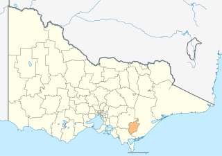
The City of Latrobe is a local government area in the Gippsland region in eastern Victoria, Australia, located in the eastern part of the state. It covers an area of 1,426 square kilometres (551 sq mi) and in June 2018 had a population of 75,211. It is primarily urban with the vast majority of its population living within the four major urban areas of Moe, Morwell, Traralgon, and Churchill, and other significant settlements in the LGA include Boolarra, Callignee, Glengarry, Jeeralang, Newborough, Toongabbie, Tyers, Yallourn North and Yinnar. It was formed in 1994 from the amalgamation of the City of Moe, City of Morwell, City of Traralgon, Shire of Traralgon, and parts of the Shire of Narracan and Shire of Rosedale. The Yallourn Works Area was added in 1996. When formed, the municipality was called the Shire of La Trobe, but on 6 April 2000, it adopted its current name.

Jumbunna is a town in South Gippsland, Victoria, Australia. The name is taken from the eastern Kulin language of the Bunnerong tribe and means "a place to meet and talk".

Victorian Heritage Register Heritage register of places in Victoria, Australia

The Victorian Heritage Register (VHR) lists places deemed to be of cultural heritage significance to the State of Victoria, Australia. It has statutory weight under the Heritage Act 2017. The Minister for Planning is the responsible Minister. Heritage Victoria was established as the State Government listing and permit authority in 1995, replacing the original authority, the Historic Buildings Preservation Council, established in 1974. Listing on the Victorian Heritage Register is separate from listing by a local Council or Shire, known as a Heritage Overlay. Heritage Victoria is currently part of the Department of Environment, Land, Water and Planning of the Government of Victoria, Australia. Heritage Victoria reports to the Heritage Council who approve recommendations to the Register and hear appeals when a registration is disputed. The council also hears appeals by an owner to a permit issued by Heritage Victoria. As of 2021, there are over 2,400 places and objects listed on the VHR.

Bendoc is a locality in the Shire of East Gippsland, Victoria, Australia. It sits on the Bendoc River. In the 2016 census, Bendoc had a population of 115 people.

Deptford is a locality in the Shire of East Gippsland, Victoria, Australia. In the 2016 census, Deptford had a population of zero.

Flynn is a locality in Victoria, Australia, situated on the border of the City of Latrobe and Shire of Wellington. In the 2016 census, Flynn had a population of 180.

References

  1. "East Gippsland Shire". Victorian Heritage Database. Heritage Council of Victoria. Retrieved 16 November 2021.