This is a list of places on the Victorian Heritage Register in the City of Moonee Valley in Victoria, Australia. The Victorian Heritage Register is maintained by the Heritage Council of Victoria.
The Victorian Heritage Register, as of 2020, lists the following 24 state-registered places within the City of Moonee Valley: [1]
| Place name | Place # | Location | Suburb or Town | Co-ordinates | Built | Stateregistered | Photo |
|---|---|---|---|---|---|---|---|
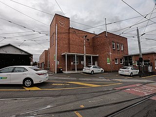
| Ascot Vale Tram Substation | H2323 | 53 Maribyrnong Rd | Ascot Vale | 37°46′21″S144°55′16″E / 37.772550°S 144.920980°E | 1925 | 12 December 2013 | |
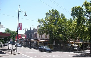
| Canary Island Date Palm Avenue | H1200 | Mt Alexander Rd | Essendon | 37°45′06″S144°54′54″E / 37.751670°S 144.915120°E | 1929 | 19 September 1996 |  |
| Clydebank | H1325 | 22 Vida St | Aberfeldie | 37°45′25″S144°53′53″E / 37.756990°S 144.898030°E | 1888 | 19 June 1997 | |
| ES&A Bank Building | H1287 | 403-405 Mt Alexander Rd | Ascot Vale | 37°46′28″S144°55′39″E / 37.774490°S 144.927500°E | 1884 | 10 August 2017 | |
| Essendon High School | H1294 | 286 Buckley St | Essendon | 37°45′17″S144°54′08″E / 37.754820°S 144.902140°E | 1912-13 | 20 February 1997 | |
| Essendon Incinerator Complex | H0434 | 180 Holmes Rd | Aberfeldie | 37°45′52″S144°54′11″E / 37.764450°S 144.903150°E | 1929-30 | 31 January 1979 |  |
| Essendon railway station | H1562 | 2-26 Russell St | Essendon | 37°45′22″S144°54′59″E / 37.756170°S 144.916310°E | 1909 | 20 August 1982 |  |
| Essendon Technical School | H1295 | 38 Buckley St | Essendon | 37°45′27″S144°55′24″E / 37.757370°S 144.923310°E | 1938-39 | 20 February 1997 | |
| Essendon Tramway Depot | H1215 | 318 Mt Alexander Rd | Travancore | 37°46′44″S144°55′53″E / 37.778780°S 144.931310°E | 1906 | 24 October 1996 |  |
| Flemington Court House | H1470 | 28 Wellington St | Flemington | 37°47′08″S144°55′55″E / 37.785630°S 144.932070°E | 1889 | 21 December 1988 |  |
| Flemington Police Station and Lock Up | H0844 | 30 Wellington St | Flemington | 37°47′07″S144°55′56″E / 37.785260°S 144.932250°E | 1890 | 6 February 1991 | |
| Flemington Post Office | H1201 | 2A Wellington St | Flemington | 37°47′14″S144°55′55″E / 37.787330°S 144.931850°E | 1889-90 | 19 September 1996 |  |
| Glendalough | H1202 | 197-199 Cashmere St | Travancore | 37°46′42″S144°56′02″E / 37.778360°S 144.933950°E | 1923 | 19 September 1996 | |
| Infant Building, Moonee Ponds West Primary School | H1321 | 123 Eglinton St | Moonee Ponds | 37°46′08″S144°54′32″E / 37.768750°S 144.908810°E | 1911-13 | 19 June 1997 | |
| Lowther Hall | H0146 | 29 Leslie Rd | Essendon | 37°45′34″S144°54′54″E / 37.759370°S 144.915020°E | 1890 | 9 October 1974 | |
| Newmarket Railway Substation | H1199 | 132-164 Newmarket St | Flemington | 37°47′04″S144°55′34″E / 37.784360°S 144.925990°E | 1914-15 | 19 September 1996 | |
| North Park | H1286 | 69 Woodland St | Essendon | 37°44′37″S144°55′25″E / 37.743590°S 144.923570°E | 1888 | 9 January 1997 | |
| Nathan's Terrace | H1205 | 4-14 Wellington St and 1-11 Shields St | Flemington | 37°47′13″S144°55′55″E / 37.786830°S 144.932080°E | 1889 | 24 October 1996 | |
| Old Moonee Ponds Court House | H1051 | 770 Mt Alexander Rd | Moonee Ponds | 37°45′52″S144°55′27″E / 37.764480°S 144.924160°E | 1890 | 8 September 1994 |  |
| Park View | H1203 | 512-518 Racecourse Rd | Flemington | 37°47′14″S144°55′23″E / 37.787200°S 144.923180°E | 1924 | 19 September 1996 | |
| Prefabricated Residence | H1207 | 51 Ormond Rd | Moonee Ponds | 37°46′22″S144°55′53″E / 37.772720°S 144.931490°E | 1914-15 | 24 October 1996 | |
| Queen's Park Curator's Cottage | H1078 | 776-780 Mt Alexander Rd | Moonee Ponds | 37°45′43″S144°55′23″E / 37.761920°S 144.923100°E | 1891-98 | 20 April 1995 | |
| Residence | H1160 | 2 Riverview Rd | Essendon | 37°45′35″S144°54′48″E / 37.759750°S 144.913290°E | 1935 | 18 April 1996 | |
| St Monica's Catholic Church | H1217 | 818 Mt Alexander Rd | Moonee Ponds | 37°45′36″S144°55′17″E / 37.759930°S 144.921420°E | 1934 | 24 October 1996 | |