The Shire of Nillumbik is a local government area in Victoria, Australia. It contains outer northern suburbs of Melbourne and rural localities beyond the urban area. It has an area of 432 square kilometres and at the 2021 census, the Shire had a population of 62,895. It was formed in 1994 from the merger of parts of the Shires of Eltham, Diamond Valley, Healesville and the City of Whittlesea. The Shire uses the tag-line The Green Wedge Shire. The Nillumbik Council offices are located in Civic Drive, Greensborough.

The City of Whittlesea is a local government area located in the outer northern suburbs of Melbourne, the state capital of Victoria, Australia. The city covers an area of 490 square kilometres (189.2 sq mi), and in June 2018, it had a population of 223,322.

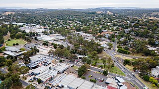
Eltham is a suburb of Melbourne, Victoria, Australia, 20 km north-east of the Central Business District, located within the Shire of Nillumbik local government area. Eltham recorded a population of 18,847 at the 2021 census.
Diamond Creek is a suburb of Melbourne, Victoria, Australia, 23 km north-east of Melbourne's Central Business District, located within the Shire of Nillumbik local government area. Diamond Creek recorded a population of 12,503 at the 2021 census.

Kangaroo Ground is a town in Victoria, Australia, 26 km north-east of Melbourne's Central Business District, located within the Shire of Nillumbik local government area. Kangaroo Ground recorded a population of 1,208 at the 2021 census.

Smiths Gully is a town in Victoria, Australia, 35 km north-east of Melbourne's Central Business District, located within the Shire of Nillumbik local government area. Smiths Gully recorded a population of 356 at the 2021 census.
Yarra Plenty Regional Library (YPRL) provides a public library service to the local government municipalities of the City of Banyule, Shire of Nillumbik and City of Whittlesea in the northeast of Melbourne Australia and located on the lands of the Woiworung. It is an independent legal entity with an executive management team which is responsible for day-to-day operations of the organisation. It is managed by the Yarra Plenty Regional Library Board made of two representatives (councillors) of the three municipalities that constitute the service. Its role is to set the policy and direction for the regional library service. The library service covers an area of 988.4 km² including metropolitan, urban fringe and rural populations. The organisation is administered from its Library Support Services (LSS) located at Daniher Drive, Sth Morang.
Bend of Islands is a rural locality in Victoria, Australia, 30 km north-east of Melbourne's Central Business District, located within the Shire of Nillumbik local government area. Bend of Islands recorded a population of 267 at the 2021 census.

The Shire of Diamond Valley was a local government area about 20 kilometres (12 mi) northeast of Melbourne, the state capital of Victoria, Australia. The shire covered an area of 74.38 square kilometres (28.72 sq mi), and existed from 1964 until 1994.

The Shire of Eltham was a local government area about 25 kilometres (16 mi) northeast of Melbourne, the state capital of Victoria, Australia. The shire covered an area of 277.13 square kilometres (107.0 sq mi), and existed from 1856 until 1994.

Kangaroo Ground War Memorial Park is located at 385 Eltham Yarra Glen Road, Kangaroo Ground in the Shire of Nillumbik. in Victoria, Australia. The site includes the war memorial, with a firespotting cabin, mature monterey cypress trees and other planted species, and a sandstone caretaker's cottage. The park is situated on the summit of Garden Hill, from which panoramic views are obtainable. The park is situated on two acres.
The Victorian Heritage Inventory, commonly known as the Heritage Inventory, is a list of all known historical archaeology sites in Victoria, Australia. It is maintained by Heritage Victoria , the Victorian State Government’s principal cultural (non-Indigenous) heritage agency.
Eltham District Historical Society is a community organisation devoted to the collection, preservation and sharing of stories about the local history of the Eltham district in the north east of Melbourne, Victoria, Australia. Its geographic area of interest extends from Lower Plenty and Montmorency to Kangaroo Ground. It also maintains an interest in the former Shire of Eltham and holds memorabilia from the former Eltham Shire Council. It is located in the Shire of Nillumbik local government area. It also encourages conservation of significant places, spaces and documents for future generations. It is an affiliated member of the Royal Historical Society of Victoria and the Association of Eastern Historical Societies. It is an historical society managed by volunteers.


