
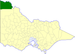
The Rural City of Mildura is a local government area in Victoria, Australia, located in the north-western part of the state. It covers an area of 22,083 square kilometres (8,526 sq mi) being the largest LGA in the state. In August 2021 the area had a population of 56,972. It includes the city of Mildura and the towns of Merbein, Red Cliffs, Irymple, Ouyen, Werrimull, Murrayville, Walpeup and Hattah. It was formed in 1995 from the amalgamation of the City of Mildura, Shire of Mildura and Shire of Walpeup.

Mildura is a regional city in north-west Victoria, Australia. Located on the Victorian side of the Murray River, Mildura had a population of 34,565 in 2021. When nearby Wentworth, Irymple, Nichols Point, Merbein and Red Cliffs are included, the combined urban area had a population of 58,914 in 2021, having grown marginally at an average annual rate of 1.3% year-on-year over the preceding five years.

Creswick railway station is located on the Mildura line in Victoria, Australia. It serves the town of Creswick, and the original station opened on 7 July 1874.
Russell Irwin Savage is an Australian politician, who was the independent member for the Victorian Legislative Assembly seat of Mildura from 1996 until 2006. Prior to entering politics, he was a long-serving police officer in Victoria and England.
Boinka is a locality situated on the section of the Mallee Highway and Pinnaroo railway line between Ouyen and the South Australian border in the Sunraysia region of Victoria, Australia. Boinka is situated approximately 4 kilometres east from Tutye and 8 kilometres west from Linga.
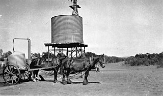
The Shire of Mildura was a local government area located at the northwestern corner of Victoria, Australia, on the Murray River and the South Australian border. The shire covered an area of 10,145 square kilometres (3,917.0 sq mi), and existed from 1890 until 1995. From 1920 onwards, Mildura itself was managed by a separate entity, ultimately known as the City of Mildura.

The Shire of Walpeup was a local government area in northwestern Victoria, Australia, along the South Australian border. The shire covered an area of 10,964 square kilometres (4,233.2 sq mi), and existed from 1911 until 1995.

The City of Mildura was a local government area on the Murray River, in northwestern Victoria, Australia. The city covered an area of 29.86 square kilometres (11.5 sq mi), and existed from 1920 until 1995.
Nowingi is a locality in Victoria, Australia, approximately 50 kilometres (31 mi) south of Mildura. It is in the local government area of the Rural City of Mildura.
Criminal activity in Victoria, Australia is combated by the Victoria Police and the Victorian court system, while statistics about crime are managed by the Crime Statistics Agency. Modern Australian states and cities, including Victoria, have some of the lowest crime rates recorded globally with Australia ranked the 13th safest nation and Melbourne ranked the 5th safest city globally. As of September 2018 the CBD of Melbourne had the highest rate of overall criminal incidents in the state (15,949.9), followed by Latrobe (12,896.1) and Yarra (11,119.2). Rural areas have comparatively high crime rates, with towns such as Mildura (9,222.0) and Greater Shepparton (9,111.8) having some of the highest crime rates in the state.

The George Chaffey Bridge is a road bridge in Australia that carries the Sturt Highway across the Murray River from Buronga to Mildura.
Jade Benham is an Australian politician who is the current member for the district of Mildura in the Victorian Legislative Assembly. She is a member of the Nationals and was elected in the 2022 state election, after defeating incumbent MLA Ali Cupper.


