
The City of Banyule is a local government area in Victoria, Australia in the north-eastern suburbs of Melbourne. It was created under the Local Government Act 1989 and established in 1994 as an amalgamation of former councils. It has an area of 63 square kilometres (24.3 sq mi) and lies between 7 and 21 km from central Melbourne. In 1994 it had a population of 116,000. In June 2018 Banyule had a population of 130,237. The Yarra River runs along the City's southern border while its western border is defined by Darebin Creek.

Queenscliff is a small town on the Bellarine Peninsula in southern Victoria, Australia, south of Swan Bay at the entrance to Port Phillip. It is the administrative centre for the Borough of Queenscliffe. At the 2016 census, Queenscliff had a population of 1,315.

Heidelberg is a suburb of Melbourne, Victoria, Australia, 11 kilometres (7 mi) northeast of Melbourne's central business district, located within the City of Banyule local government area. Heidelberg recorded a population of 7,360 at the 2021 census.

Elizabeth Street is one of the main streets in the Melbourne central business district, Victoria, Australia, part of the Hoddle Grid laid out in 1837. It is presumed to have been named in honour of governor Richard Bourke's wife.

La Trobe Street is a major street and thoroughfare in the Melbourne central business district, Victoria, Australia. It runs roughly east–west and forms the northern boundary of the central business district. The street was laid out as an extension of the original Hoddle Grid in 1839 and was named after Charles La Trobe. La Trobe Street extends from Victoria Street in the east to Harbour Esplanade in the west.

In Australia, an Avenue of Honour is a memorial avenue of trees, with each tree symbolising a person. The tradition, which originated in the Goldfields region of Victoria, Australia, is an important part of Australian culture. There are 547 known avenues of honour in Australia, in all states and territories except the Northern Territory. Over half are in Victoria.
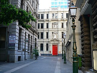
Bank Place is a street in the Melbourne central business district, Australia. It is a laneway running roughly north-south between Collins Street and Little Collins Street.
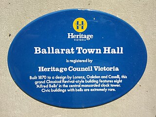
Heritage Victoria is a branch of the Victorian Department of Transport and Planning. It is the regulator responsible for administering the Heritage Act 2017. The Heritage Act provides for the protection and conservation of the cultural heritage of Victoria and establishes the Victorian Heritage Register and Heritage Inventory. The Register is a list of places and objects which are of significance to the State of Victoria. The Inventory is a list of known historical archaeological sites. Both statutory lists can be searched via the Victorian Heritage Database.
Mannerim is a semi-rural locality on the Bellarine Peninsula of Victoria, Australia.

The Queen's Bridge is a historic road bridge over the Yarra River in Melbourne, Victoria, Australia. The bridge was built in 1889 and has five wrought iron plate girder spans and is listed on the Victorian Heritage Register. The bridge was built by contractor David Munro and replaced a timber footbridge built in 1860.

Westgarthtown is a heritage registered precinct located within the Melbourne suburbs of Thomastown and Lalor, in Victoria, Australia.
The Margaret Lyttle Memorial School Junior Campus is the junior campus of Preshil. It was designed by Kevin Borland. The buildings that Kevin Borland designed at the Preshil School are experimental in design and use triangular and hexagonal geometries together with diagonals in both plan and section. This creates a variety of internal and external spaces, irregular forms and buildings that strongly deviates from the conventional school buildings of that time. The precise forme of each building and its detailing is counteracted by the use of raw timber posts and beams.
The Northcote Farm School (NFS) was a farm school built at Glenmore, near Bacchus Marsh, Victoria, in 1937.
The Bendigo Law Courts is a building on Pall Mall in Bendigo, a regional city in the Australian state of Victoria. The courts back onto and are partly surrounded by Rosalind Park. The building was built between 1892 and 1896 by the contractors McCulloch and McAlpine and designed by Public Works architect George W. Watson. The building was constructed in the Victorian Second Empire style been described as reminiscent of an Italianate palazzo and shares a great deal with its neighbouring building, the Bendigo Post Office, which was also designed and built by Watson, McColloch and McAlpine 10 years earlier. The Law Courts are built of rendered brick and Harcourt (Victoria) Bluestone.
Oakden, Addison and Kemp was an Australian architectural firm in Melbourne, Victoria. While it was short lived, existing from only 1887 to 1892, they designed a number of outstanding projects, and all three members designed many more notable projects in earlier and later partnerships.

Harbour Esplanade is a waterfront street and thoroughfare in Docklands, an inner suburb of Melbourne, Victoria, Australia. It runs roughly north-south from Navigation Drive in the south to Docklands Drive in the north. The road also forms the eastern boundary of the Victoria Harbour inlet and is adjacent to Victoria Dock.

W. B. Fox's Villa is a historic farmhouse built in 1867 in Clifton Hill, Victoria, Australia. It was also known as The House of the Gentle Bunyip, an intentional Christian community established by Athol Gill. In the 1990s, the building had fallen into disrepair and was planned to be demolished. Clifton Hill residents picketed the site for over 400 days, ultimately preventing its demolition. In 2008, the building was subsequently re-purposed as supported accommodation for people with schizophrenia. W.B. Fox's Villa is included in the statement of significance for the Clifton Hill West Precinct area in the Victorian Heritage Database.


