This is a list of places on the Victorian Heritage Register in the Shire of Cardinia in Victoria, Australia. The Victorian Heritage Register is maintained by the Heritage Council of Victoria.
The Victorian Heritage Register, as of 2020, lists the following eight state-registered places within the Shire of Cardinia: [1]
| Place name | Place # | Location | Suburb or Town | Co-ordinates | Built | Stateregistered | Photo |
|---|---|---|---|---|---|---|---|
| Bayles Bridge No. 1 and No. 2 | H1852 | Koo Wee Rup-Longwarry Rd over Yallock Creek | Bayles | 38°10′45″S145°34′25″E / 38.179120°S 145.573490°E | 1950 | 18 November 1999 | |
| Bunyip Railway Substation | H2025 | Nar Nar Goon-Longwarry Rd | Bunyip | 38°05′55″S145°42′45″E / 38.098500°S 145.712540°E | 1952 | 13 November 2003 |  |
| Cockatoo Kindergarten | H2303 | 2-10 McBride St | Cockatoo | 37°56′10″S145°29′27″E / 37.936070°S 145.490810°E | 1976 | 10 May 2012 | |
| Harewood | H0284 | 3300 South Gippsland Hwy | Koo Wee Rup | 38°12′46″S145°25′52″E / 38.212780°S 145.431220°E | 1865-68 | 9 October 1974 | |
| Kurth Kiln | H2012 | Soldiers Rd (Gembrook) Beenak Rd (Yellingbo) | Gembrook Yellingbo | 37°53′57″S145°34′32″E / 37.899250°S 145.575490°E | 1941-42 | 20 March 2003 | 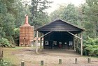 |
| Monomeith Homestead | H0452 | 405 Monomeith Rd | Monomeith | 38°11′49″S145°32′11″E / 38.196860°S 145.536440°E | 1860 | 8 August 1979 | |
| Nobelius Nursery, Packing Shed and Railway Siding | H2285 | Emerald Lake Rd and Princess Ave | Emerald | 37°55′51″S145°26′58″E / 37.930720°S 145.449360°E | 1900 | 14 June 2012 |  |
| Silverwells | H0611 | 330 Ure Rd | Gembrook | 37°55′09″S145°32′53″E / 37.919220°S 145.548070°E | 1879 | 11 December 1985 | |