List of places on the Victorian Heritage Register in the Shire of Gannawarra

Last updated

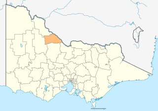
This is a list of places on the Victorian Heritage Register in the Shire of Gannawarra in Victoria, Australia. The Victorian Heritage Register is maintained by the Heritage Council of Victoria.

The Victorian Heritage Register, as of 2021, lists the following four state-registered places within the Shire of Gannawarra: [1]

Place namePlace #LocationSuburb or TownCo-ordinatesBuiltState
registered
Photo
Bael Bael Homestead H2196 Lake Charm-Quambatook Road Bael Bael 35°41′23″S143°43′22″E / 35.689690°S 143.722850°E / -35.689690; 143.722850 c. 1870s13 February 2009
Barham-Koondrook Bridge H0795 Kerang-Koondrook Road
over the Murray River
Koondrook 35°37′50″S144°07′29″E / 35.630473°S 144.124861°E / -35.630473; 144.124861 190310 July 2008 Koondrook-Barham bridge.jpg
Condidorios Bridge H1799 Island Road
over Gunbower Creek
Koondrook 35°39′01″S144°08′01″E / 35.650200°S 144.133580°E / -35.650200; 144.133580 190622 April 1999
Koondrook Tram Complex H1570 Main Street
Kerang-Koondrook Road
Koondrook
Teal Point
35°38′31″S144°07′53″E / 35.642060°S 144.131350°E / -35.642060; 144.131350
35°39′48″S144°05′58″E / 35.663400°S 144.099425°E / -35.663400; 144.099425
35°40′43″S144°04′04″E / 35.678743°S 144.067794°E / -35.678743; 144.067794
35°41′23″S144°03′14″E / 35.689831°S 144.053824°E / -35.689831; 144.053824
188920 August 1982

Related Research Articles

<span class="mw-page-title-main">Shire of Gannawarra</span> Local government area in Victoria, Australia

The Shire of Gannawarra is a local government area in Victoria, Australia, located in the northern part of the state. It covers an area of 3,735 square kilometres (1,442 sq mi) and, in August 2021 had a population of 10,683.

<span class="mw-page-title-main">Kyneton</span> Town in Victoria, Australia

Kyneton is a town in the Macedon Ranges region of West Central Victoria, Australia. The Calder Freeway bypasses Kyneton to the north and east. Kyneton is on Dja Dja Wurrung, Taungurung and Wurundjeri Woi Wurrung country.

<span class="mw-page-title-main">Victorian Heritage Register</span> Heritage register of places in Victoria, Australia

The Victorian Heritage Register (VHR) lists places deemed to be of cultural heritage significance to the State of Victoria, Australia. It has statutory weight under the Heritage Act 2017. The Minister for Planning is the responsible Minister. Heritage Victoria was established as the State Government listing and permit authority in 1995, replacing the original authority, the Historic Buildings Preservation Council, established in 1974. Listing on the Victorian Heritage Register is separate from listing by a local Council or Shire, known as a Heritage Overlay. Heritage Victoria is currently part of the Department of Environment, Land, Water and Planning of the Government of Victoria, Australia. Heritage Victoria reports to the Heritage Council who approve recommendations to the Register and hear appeals when a registration is disputed. The council also hears appeals by an owner to a permit issued by Heritage Victoria. As of 2021, there are over 2,400 places and objects listed on the VHR.

<span class="mw-page-title-main">Quambatook</span> Town in Victoria, Australia

Quambatook is a town in northern Victoria, Australia.

<span class="mw-page-title-main">Shire of Cohuna</span> Local government area in Victoria, Australia

The Shire of Cohuna was a local government area on the Murray River, about 265 kilometres (165 mi) north-northwest of Melbourne, the state capital of Victoria, Australia. The shire covered an area of 494.69 square kilometres (191.0 sq mi), and existed from 1922 until 1995.

References

  1. "Gannawarra Shire". Victorian Heritage Database. Heritage Council of Victoria. Retrieved 28 December 2021.