In the United Kingdom, the term "listed building" refers to a building or other structure officially designated as being of special architectural, historical or cultural significance. These buildings are in three grades: Grade I consists of buildings of outstanding architectural or historical interest; Grade II* includes particularly significant buildings of more than local interest; Grade II consists of buildings of special architectural or historical interest. Buildings in England are listed by the Secretary of State for Culture, Media and Sport on recommendations provided by Historic England, which also determines the grading.[6]
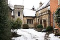
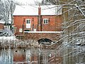
A small number of Sleaford's medieval buildings have survived. St Denys' Church in Sleaford and St Botolph's in Quarrington date to the 12th and 13th centuries respectively; considered a particularly fine example of England's Decorated Gothic church architecture,[7] St Denys' is especially noted for its flowing tracery and is Sleaford's only Grade-I-listed building. The half-timbered vicarage immediately to the north is 15th-century and Grade-II*-listed. Though the present building dates to the 18th century, Cogglesford Mill also has medieval origins and is the only remaining watermill of the dozen or so which were once powered by the River Slea; it is a testament to the river's economic importance from the Saxon period onwards.[8] It is likely that a market was held at Sleaford during the late Saxon period, but it grew under its post-conquest lords of the manor, the Bishops of Lincoln, who used the settlement as a base (constructing Sleaford Castle, of which only a fragment now survives) and extracted produce through demesne farming. The bishops also tried to create some commercial growth through granting burgage tenure, limited freedoms and the right to hold a market, so that they could generate an income through charging rents, levying tolls and taxing market traders.[9] As a result, the town's historic core comprises the market place and the four roads which meet at it: Northgate, Southgate, Eastgate and Westgate; many of the listed buildings are found in this area.
Buildings in this core often date to the 18th and 19th centuries and include William Alvey's fine Baroque house on Northgate,[10] the Manor House on Northgate inset with medieval fragments, and Sessions House on the Market Place, as well as several dozen more modest domestic buildings and shops. The Carre family, who owned the manor in the 16th and 17th centuries,[11] were responsible for the grammar school, the hospital and the almshouses, though the buildings all date to the Victorian period. During the Industrial Revolution, the Slea was canalised in 1794 and the Sleaford Navigation which managed it constructed its offices along Carre Street where the canal terminated; industries and wharves sprung up there.[12] The canal brought trade to Sleaford and the town prospered.[13] The 19th-century builders Kirk and Parry constructed or added to numerous public buildings and private residences, including the listed Lafford Terrace and their own houses on Southgate and at Westholme respectively, while the new gasworks powered lamps around the town from 1839. In 1857, the railways arrived and the station was built in a Gothic style. Sleaford's agricultural location and its new transport links encouraged seed trading, malting and other agriculture-related industry in the late 19th century:[13][14] the seed merchant Charles Sharpe's Grade-II-listed house, The Pines, is on Boston Road, while the massive disused Edwardian Bass and Co. maltings off Mareham Lane is listed as Grade II*. In the late 20th century, Sleaford's urban area expanded to incorporate the surrounding villages of Quarrington and Holdingham.[15] None of the modern suburban housing built at this time has been listed, but the historic cores of those settlements include several listed farmhouses and cottages. Old Place, the much-modified former manor house at the former settlement of Old Sleaford, now also sits within the town's urban area.
c. 1180 (tower), with later medieval nave, aisles and transept, and Victorian alterations and spire
There has probably been a church in Sleaford since at least the Norman Conquest,[16] but the oldest parts of St Denys' Church date to c. 1180. It consists of an Early English Gothic tower, with a stone broach spire, a Decorated Gothicnave and aisles, and a north transept. Kirk and Parry restored the church in 1853 and the spire was rebuilt after it was struck by lightning in 1883. The rood screen is medieval and was removed from Lincoln Cathedral.[17] St Denys' is considered to be an outstanding example of Decorated Gothic church architecture in England,[7] with its tracery being especially praised.[18]
The L-shaped Carre's Hospital is built on the site of the Carre family's house. Designed by H. E. Kendall, the east range of 1830 spans nine windows; the south range, completed between 1841 and 1846[19] (possibly by Charles Kirk[20]) spans seven windows and has a large central chapel and a Perpendicular Gothic window overlooking the courtyard.[19] There is a front lawn with a sundial and water pump.[20]
13th century, with later medieval and 19th century fabric
A church at Quarrington is recorded in the Domesday Book;[21] however, the 13th-century north arcade is the oldest part of the existing church. Its tower and spire date to the next century and St Botolph's listing reflects the "excellent" 14th-century tracery in two of its windows. The chancel was rebuilt when Charles Kirk restored the church in 1862−3.[22]
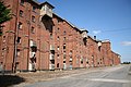
Local barley production and the town's railway links made Sleaford desirable for brewing beer. Bass & Co. constructed the maltings in brick between 1892 and 1907. They comprise eight separate pavilions with a four-storey tower in the centre; the total frontage is nearly 1,000ft.[23] Pevsner and colleagues commented that "for sheer impressiveness little in English industrial architecture can equal the scale of this building."[24] The maltings at Sleaford closed in 1959, though parts of the building were let for other uses. Vacant since 2000, the site has been damaged by fire on several occasions[23] and is listed among English Heritage's most "at risk" buildings.[25][26]
16th century, with much 19th century modification (No 31); mid 18th century (No 33)
Set back from the street and entered across a courtyard, the Manor House is largely 19th-century Gothic, but attached to part of a 16th- or 17th-century building.[27] The architectural historian Sir Nikolaus Pevsner and colleagues considered it a "jigsaw puzzle",[28] for it incorporates medieval stonework, including a 14th-century chimney piece from the Old Deanery in Lincoln and masonry from Sleaford Castle, as well as early modern stonework.[27][28] It is thought that Charles Kirk may have been responsible for much of this.[28] It is, in Pevsner etal's view, "hard to discriminate between what is genuine and what is 19th-century fancy".[28] The adjoining Georgian Rhodes House is brick-built and faces onto Northgate.[27]
Designed by H. E. Kendall, the Gothic Revival Sessions House has two storeys topped with an embattledparapet. Facing onto the Market Place, the ground level is arcaded with six pointed arches; the first floor has six windows.[29] The building served as the magistrates court for the Sleaford area (formerly the Sleaford Petty Sessions) until 2010.[30] It was converted to a restaurant in 2010.[31] It had also served as the meeting place of Kesteven County Council from 1889 to 1960 and for the town's urban district council from 1894 to 1911.[32]
A two-storey timber-framed building, the Vicarage is 15th-century, with a late 16th-century chimney-piece and a brick extension of 1861 by Charles Kirk. The ground floor of the earlier wing is rendered; the first floor is half-timbered and contains a central bay window beneath a large gable with timber jetties.
A hexagonal, wooden-panelledgarden house at the Pines on Boston Road, a house owned by the seed merchant Charles Sharpe in the late 19th century. The exterior and interior are decorated with split branches, and the windows are stained glass.
1530s with much from the early to mid 19th century
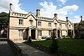
Old Place contains a Tudor stone core, dating mostly to the 1530s, but altered and with a brick second floor added probably in the early 1820s.[36] There are extensive 19th-century Gothic additions. Its eastern wings date to the early Victorian period (having been completed by 1849) and its northern extension was built between 1888 and 1903.[37] Its garden wall is built from medieval stone fragments.[38]
The house occupies the site of the manor house at Old Sleaford, owned by the Hussey family from the 15th century to the early 16th century, when the Carre family took over the estate (it passed into the hands of the Earls, later Marquesses, of Bristol in 1688). It became a farm house during the Carre family's ownership,[39] but was converted into multiple residences in the late 1940s and renovated in the 1980s by the builders Jelson and Co.[40]
The site was developed by John Sharpe, a seedsman, in the 1830s, then enlarged by his son, Charles, fifty years later. The house is in yellow brick with stone decorations. Of two storeys and spanning five bays, the east front has a central tower with doors fitted between two pairs of Doricpilasters. The 13-bay former warehouse is attached to the south.
A brick two-storey terraced block with three windows on the first floor; Nos 33 and 35 are rendered and form one property. The latter has a late Victorian shopfront.
A portico with the inscription "1792 Sleaford Navigation", the doorway has two large stone pilasters under a triangular pediment.[50] The doorway was moved from an unknown location to this site in c. 1823.[51]
A stone two-storey building in the Tudor style, it is believed to have housed the offices of the Sleaford Navigation company and bears a carved rendition of that company's armorial bearings above the doorway.[52] Pevsner and colleagues call it Navigation House and date it to 1838–39.[20] According to the local historians Anthony Brand and Simon Pawley, it was built in 1838 by Bothewary and Brewin, of Grantham, probably to a design by Charles Kirk.[53]
The only surviving part of the castle is a small section of masonry. Constructed by Alexander, Bishop of Lincoln, it was double-moated.[54] Thought to have been built between 1123 and 1139, Sleaford Castle remained in a good state of repair into at least the 1530s, but was ruined by the 17th-century. Its earthworks remain visible.[29]
A two-storey watermill, the ground floor dates from the 18th century; the upper floor is a 19th-century addition. The building is made of a mix of limestone rubble and brick. The west front has a door, windows and a sliding entrance leading to the loft, while the southern side has a brick arch. There is a 19th-century shed attached to the north, a stepped mill race with brick walls to the south, and a brick footbridge to the west.
The Sleaford Gas Light Company was founded in 1838 and its gas works opened the following year. Probably designed by H. E. Kendall, the entrance is in stone and has two two-storey gabled pavilions at its ends connected by lower two-storey links to a central archway with buttresses and a crow-stepped gable.[61] The buildings were extended to the rear in the 1890s, but these additions were demolished in 1966–1968 after gas production ceased at Sleaford.[62]
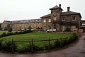
This Italianate yellow brick and stone terrace was built by Kirk and Parry in 1856. It has one three-storey pavilion in the centre and two at each end connected by two-storey links.[63] Although initially residential, the leases to all but one of the apartments were purchased by Kesteven County Council (KCC) in 1925 and developed into their offices; the final lease was acquired in the late 1930s. After KCC's abolition in 1974, it was transferred to the newly established North Kesteven District Council, serving as its offices thereafter and, after a major extension in 1991, becoming its sole office building and host to its council chamber.[64]
A one-storey building (with a gabled attic) in coarsed rubble. On the street front is a 19th-century shopfront with three windows and a door beneath an oriel window. The church-facing side to the rear is 18th-century and spans two storeys and three bays with a 19th-century extension in brick across three bays.
A rubble two-storey building with stone gables and Georgian brick extensions. The street front consists of four windows on the first floor and three on the ground floor; the eastern gable includes a stone window dated to around the 17th century. There are adjoining outbuildings and malthouses and the stonework incorporates 15th-century material from Sleaford Castle.
No 13 was the Waggon and Horses public house, and the brick building occupies three storeys across three bays. No 15 has two storeys and two bays.[76] The pub closed in 2011 and has been converted into apartments.[77]
Built and designed by Charles Kirk, the former schoolhouse and chapel once served Quarrington as a primary school. It was built in 1867.[87] The school was extended in 1898, the 1960s and 1980s. In 2002, the school moved to another site, leaving the premises vacant.[88] The original building is single-storey in coursed stone and adopts a Gothic Revival style, with mullioned windows. The Grantham Road front has six windows and a central gable supporting a school bell; the rear has a doorway between two gables. There is also a school chapel with an arched roof inside and buttresses on the exterior.[87]
Probably built by Kirk and Parry, this coursed-stone office building with Gothic Revival details has been converted into an annexe for Kesteven and Sleaford High School. It consists of one storey and an attic, and the layout follows an L-shape. The eastern corner of the street front has a gabled plinth. It likely served as an office for Kirk and Parry's architectural practice, which was based on Jermyn Street.[96] From around 1902 to 1927, this building served as Kesteven County Council's offices, before the county council moved into Lafford Terrace; it was then occupied by Sleaford Urban District Council, who had already occupied the surrounding depot and offices since 1919,[97] before it became part of Kesteven and Sleaford High School in 1956,[98] after which it was converted to an annexe for the school.[96]
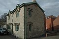
A brick building of two storeys and an attic, spanning three bays at irregular heights.[103] There is a datestone of 1793; it was owned by a tanner, William Rowland, in the late 18th century.[104]
Built by Marmaduke Bennison, this group of brick-fronted terraced houses are in ashlar and follow a Jacobethan style. There is a central gable between six dormer windows. Each of the six entrance doors are paired and the windows are mullioned.[105] In conjunction with Lafford Terrace, Pevsner and his colleagues note that Kingston Terrace and some of the surrounding mid-19th century buildings give "this part of the town... the comfortable and prosperous air of a mid-19th-century spa town".[20]
A two-storey building in coursed stone with a steep roof. The building has two mullioned windows on the first floor and two windows on the ground level.
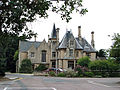
Built by Charles Kirk the younger for his business partner Thomas Parry, this stone house is, in Pevsner's words, "an ebullient essay in French 15th-century domestic Gothic".[109] Following an irregular layout, the two-storey house incorporates tall chimney stacks, dragon motifs, carved pinnacles, four-arch windows and doorways and steep roofs.[110] After the Second World War, it came into public ownership and was home to the headquarters of Kesteven County Council's library service, before being used by St George's College of Technology (now St George's Academy).[111]
Designed by A. Couchman, this is a single-storey, red-brick cartshed with a tile roof and plinth in blue brick. The west front has three iron columns, filled in with 20th-century additions. It was built c. 1900 and is part of the Bass Maltings complex.
The wall around the Bass Maltings complex is made of red brick, dressed with stone and features iron railings. The main gateway has stone decoration and brick piers topped with gas lights; it encloses cast iron gates. Each side has smaller gateways under Tudor-style arches and with cast iron gates. It was all designed by A. Couchman.
A former mess room serving the Bass Maltings complex. It was designed by A. Couchman and built of red brick with a tile roof. The front has four windows, all boarded up; the doorways and windows on the sides are also boarded.
A former mess room serving the Bass Maltings complex. It was designed by A. Couchman and built of red brick with a tile roof. The front has four windows, all boarded up; the doorways and windows on the sides are also boarded.
A former mess room serving the Bass Maltings complex. It was designed by A. Couchman and built of red brick with a tile roof. The front has three boarded-up windows and there are boarded-up doorways and windows on the sides.
A former mess room serving the Bass Maltings complex. It was designed by A. Couchman and built of red brick with a tile roof. The front has four windows, all boarded up; the doorways and windows on the sides are also boarded.
A former mess room serving the Bass Maltings complex. It was designed by A. Couchman and built of red brick with a tile roof. The front has four windows, some boarded up; there are doorways and windows on the sides.
The Bass Maltings' former office block was designed by A. Couchman and built in a single storey in red brick with a tile roof. The front has a door and fanlight with three-bay projections either side; on the left is an archway.
Now privately owned, "Redcroft" was built to house the manager of the Bass Maltings complex. Designed by A. Couchman, it is in red brick with a tile roof and spans two storeys. The north side has a projecting centre with two windows and a half-timbered gable. There is an archway with a panelled door on the ground level. The right and rear sides of the building have bay windows.
Now disused, this two-storey storage depot and stables (designed by A. Couchman) served the Bass Maltings complex. Built in red brick with a tile roof, the front spans eight windows and has a projecting centre with two windows. On either side is a stable door below a loft door in the gables.
Now disused, this single-storey building (designed by A. Couchman) comprised the Weigh Offices of the Bass Maltings complex. Built in red brick with a tile roof, the front has boarded-up windows and a pair of double doors; there are three other doors to the right. There is a weigh machine in front of the windows and a small wing to the left of the building.
Designed by A. Couchman, this is a single-storey, red-brick cartshed with a tile roof and plinth in blue brick. The west front has three iron columns filled in with 20th-century additions. It was built c. 1900 and is part of the Bass Maltings complex.
A single two-storey red-brick house, built c. 1900 to designs by A. Couchman. It was initially a cottage to house workers at the nearby Bass Maltings complex. The house has a projecting wing to the right (with a window on each floor) and a projecting porch on the left over the doorway beside a single ground-floor window.
This pair of two-storey semi-detached cottages in red brick was built to house workers at the nearby Bass Maltings complex, but has been converted into private residences. Each has a gabled front with a window on each floor and a door set back on the outer side of the house. Built in c. 1900, the houses were designed by A. Couchman and altered in the 20th century.
This pair of two-storey, semi-detached cottages in red brick was built to house workers at the nearby Bass Maltings complex, but has been converted into private residences. Each has a gabled front with a window on each floor and a door set back on the outer side of the house. Built in c. 1900, the houses were designed by A. Couchman and altered in the 20th century.
This pair of two-storey, semi-detached cottages in red brick was built to house workers at the nearby Bass Maltings complex, but has been converted into private residences. Each has a gabled front with a window on each floor and a door set back on the outer side of the house. Built in c. 1900, the houses were designed by A. Couchman and altered in the 20th century.
A red brick two-storey cottage converted into a residence, this building was built for workers at the Bass Maltings complex nearby and was designed by A. Couchman. The front has a projecting wing on its right side.
Formerly the Bristol Arms Hotel, this late-Georgian, three-storey building spans five bays. Fronted in ashlar, its windows are framed in stone. It has rusticated quoins and embattled parapets; the central bay includes a pediment which houses the only top-storey window. The ground floor has been converted into shops and in the centre is an arched entrance to the Bristol Shopping Arcade which continues behind the building.[129] The site had been occupied by The Angel Inn since the 16th century; it was renamed in 1826 to the Bristol Arms, after the Marquesses of Bristol who owned the manor.[130]
A memorial to the landowner and politician Frederick Hervey, 2nd Marquess of Bristol (d. 1864), this drinking fountain is in stone, covered by a pyramid slate roof supported by granite columns with stone bases and capitals in the Gothic Revival style. Its construction was funded by donations from the marquess's tenants.[131] The fountain was shut off in 1927 and sat disused until it was restored in 2019 by the Sleaford and District Civil Trust with the support of Heritage Lottery funding.[132]
This is a square structure (made of rubble and a tile roof) which served as Sleaford's lock-up between 1801 and 1820, in the view of the register entry[133] or from c. 1805 to 1824 in the view of the local historians Simon Pawley and Anthony Brand. It was a holding cell for persons being tried at the old Sessions House on the Market Place.[134]
Sleaford's war memorial was unveiled in a ceremony on 4 June 1922 by Mrs H. A. Peake (the wife of H. A. Peake of Westholme), a local dignitary whose three sons had been killed in the First World War.[135] H. A. Peake's brother, Major G. H. Peake of Bawtry Hall, gave the address.[135][136][137] A dedication by the parish priest, Canon Langdon, took place at the same time and there were readings by Rev. W. Calvert (of the Wesleyan Church), Rev. F. Greeves (of the Congregational Church) and Rev. G. A. Morgan (of the Primitive Methodists). The first wreaths were laid by J. T. Barnes (chairman of Sleaford Urban District Council) and Mr and Mrs H. A. Peake, followed by numerous local groups.[135] The memorial was inscribed with the names of 134 Sleafordians who died in the First World War. The memorial was rededicated on 17 September 1950 by the Bishop of Grantham after 43 names of servicemen who died in the Second World War were added.[138] Designed by Wilfrid Bond of Grantham,[135][139] the memorial consists of a thin shaft ending in a rood cross atop a hexagonal stone base with niches containing the names of the deceased and three statues of warriors. Six steps lead up to the base.[140]Remembrance Day commemorations normally take place at the war memorial.[141]
A rendered two-storey building with a tiled roof. There are two dormers on the roof and three windows on the first floor; the ground floor has rustication and a modern door and window to the left and a shopfront to the right.
Spanning three[143] stories, 4 Market Street is a brick building with a stone plinth. There are two modern windows on each of the top floor and the first floor. On the ground floor, to the left there is a doorway with a fanlight, and on the right there is a 19th-century shop window fitted into a stone surround with an arched head.
Nos 5 to 6 span three storeys in red brick with a stone plinth; the tiling on the roof is modern. The upper two floors each have four windows; on the ground floor to the left is a coach arch spanning a single bay (No 5 is behind). Also on the ground is a tall door to No 6 approached by three steps.
Formerly the town's Trustee Savings Bank, No 7 Market Place is built of ashlar and spans two stories. Decorated with quoins, it has two windows on the upper floor overlooking the market place, while the ground floor has pilasters that separate each of its three windows and its door from each other. There is an angle quoin on the edge of the building with a doorway under a round arch[n 2] on the ground floor and a window above.
This is a red brick building across 2 stories with a pantile roof housing three dormers. There are four windows on the upper floor of No 8 and a "modern" ground floor. No 9 has a door and window on the ground floor.
On the corner of Carre Street and the Market Place, this three-storey building is rendered and has quoins on the left. The upper floors each have four windows; the ground floor has a 19th-century front consisting of arcaded windows either side of a door. It is thought the rendering conceals an older building.
An ashlar neo-Georgian building spanning three storeys, No 11 features a dormer in its tile roof, two windows on the upper floor, a bay window on the first floor and a shop front on the ground level.
A three-storey ashlar building with quoins spanning four windows; the ground floor door has a fanlight.[150] The building was home to the Bissill family of surgeons from the 18th century. Rebuilt in 1853, it was still occupied by doctors in the mid-20th century.[151]
Across three storeys, this ashlar building has quoins and spans three windows; the ground floor has a shopfront.[152] There had been a draper's shop on this site from the mid 18th century and its upstairs had hosted theatrical productions around the turn of the 19th century; in 1821, it was rebuilt by Thomas Fawcett but continued to be draper's shop until 1907.[130]
Of three storeys, the ground floor is painted stone and the upper floors are brick; this building sits at the corner of the Market Place and Southgate. The left side of the market front is probably from the 20th century in a style matching the early-18th-century right side. The ground floor has arcading housing three windows and two doors; as of 2024, the door to the left and window to the right are blocked up. The Southgate side continues the early-18th-century building for three bays on the upper floors and was extended further southwards in the 19th century with brick upper floors; both parts share a ground floor in the same style with seven arched windows across the two phases.
A three-storey building, rendered with rusticated quoins. There is a modern shopfront on the ground floor and three windows on each of the upper floors.
Carre's Charity was founded in 1636, though the present building dates from the mid-19th century. Built to a Gothic Revival design, it is a coursed stone building across two storeys with a slate roof. There are three gabled porches projecting from the front, with mullion windows and balconies on the first floor. The ground floor includes arched doorways and a stone coat of arms. Adjacent to the plot is No 38 Northgate, a former savings bank, a one-storey building with a single window and door facing Northgate.[156] The savings bank moved its operation to the Market Place in 1879, after which its premises were taken over by the Charity.[157]
This coursed stone and rubble folly has ashlar decorations. Built by Charles Kirk in c. 1850, it incorporates 14th-century stonework probably collected by Kirk from other projects.
A pair of three-storey houses made of rubble with brick and ashlar decorations and slate roofs. The buildings are late-18th-century with additions, probably by Charles Kirk, from c. 1850.
A three-storey building in stone with a slate roof. There are quoins. The first floor windows are in moulded stone pediment surrounds. The ground floor contains shopfronts (No 1 being a 19th-century specimen, the rest being modern) and an arched carriageway to the right.
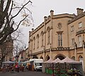
All in stone, the southern part dates to the late 17th century according to Historic England,[110] or c. 1700 in the views of Pevsner and his colleagues and the local historian Edward Trollope.[162][10] This southern section was a house for William Alvey, who built it on the site of an old inn called the Talbot; he lived at this house until his death in 1729. It was then occupied successively by Alvey Darwin and a surgeon.[162] Described by Pevsner and his colleagues as "the most remarkable house in the town",[10] it is Baroque with two storeys of three bays encased in bolection frames and a central tall doorway with a segmental porch.[10] In 1803, the Peacock, Handley and Kirton Bank took over the premises;[162] the company was purchased by Lloyds Bank in 1912.[163] The two-storey northern part is neo-Baroque, grander than the southern section, and was completed by W. Watkins and Son in 1904 or 1905 for the bank. It has a broken pediment over a door surrounded by two rusticated blocked Ionic pillars and armorial bearings above each of the three tall windows to its left.[164][10]
Built by Charles Kirk, these three adjoining two-storey houses are in rubble with quoins and decoration in stone; they have slate roofs and span six bays on the upper floor. The doorways are under Tudor-style arches.
A three-storey, yellow-brick building with a slate roof. The ground floor is in ashlar with pilasters, while the upper floors have two windows each on the Northgate side and four on the side fronting Market Street.[166] It was built in 1844 by Joseph Smedley who had taken over Robert Thornhill's printing business three years earlier and ran it from this building; the business ran there until 1898, when it became a bank.[167]
A two-storey painted brick building with a pantile roof containing three dormers. The ground floor has a modern shopfront and the upper floor has six windows.
Parry's Court includes a former gate lodge and several houses. They are a mix of 18th-century buildings and additions by Charles Kirk dating to around 1850. Built of rubble with ashlar decorations and quoins, they have slate roofs and stone gables. The buildings are across two storeys and combine a variety of window types and decorative elements.
Formerly the Lion Hotel, the Packhorse Inn is a three-storey brick building. Each floor has four windows, the ground floor also having a carriage entry to the left.[171] The Lion Hotel had opened in 1821, taking over and rebuilding the White Lion Inn which occupied the site – itself formerly called the Packhorse Inn. After the hotel's closure, it was renovated in 2004 and reopened as a public house under the name Packhorse Inn.[172]
10 and 12 Northgate occupy a three-storey brick building with quoins and a pantile roof. The ground floor has modern shopfronts and the upper floors each have five windows.
At the corner of Northgate and Church Lane, this is a three-storey building in red brick with quoins and a two-storey extension to the right of the Northgate frontage. The ground floor on the original building has a modern shopfront, while the extension has a doorway with Tuscan columns and an entablature.[174] The Sleaford Rural District Council (and then its successor the East Kesteven Rural District Council) had its offices here from 1915 to 1964.[175]
To a French Gothic design, this two-storey building is made of ashlar and sandstone. There is an archway to the left, beside a projecting centre portion housing mullion windows. It has a steep slate roof. Built as a lodge house, it was constructed by Charles Kirk.
A red-brick building with a slate roof spanning two storeys. There are three windows on the upper floor, two being bay windows. Downstairs is a Doric doorcase housing a panelled door and fanlight. The listing date it to the 18th century, though the local historians Anthony Brand and Simon Pawley have dated it to c. 1802, when it was built by the merchant and brewer John Brittain. A later occupant, William Bates, is thought to have named it Lindum House in c. 1870. It was home to Sleaford's Post Office from 1897 to 1933, continuing to host the telephone exchange until 1967.[178]
A coursed rubble two-storey public house with ashlar decorations and slate and tile roofing, there are stone chimneys on either of the building's gable ends. There is an arched doorway, mullion windows and an upstairs oriel window (the latter beneath a single centre gable). The rear has a single-storey window with doors for a garage and stable. The core dates to around 1700, but has late 18th-century changes and alternations made in c. 1860.[180] In the early 19th century, it was a particularly notorious public house in a poor part of Sleaford; its extensive redevelopment around 1857 used building materials from the bakery which had been cleared to make way for the Corn Exchange off the market square at that time.[181]
These former houses (Nos 27 and 29) are now used for commercial purposes. Spanning two storeys, they are built of coursed rubble with ashlar decorations and a tile roof with gables. The houses have arched doorways, mullion windows and stone chimney stacks. To the left of the building is an arched stone gateway to No 25 with Doric columns.[182] No 25 is known as Woodford House, named for William Woodford, who owned it in the late 18th century; it was acquired by Thomas Fawcett and was sold in 1831 to Charles Rogers, a lawyer, who went into partnership with William Foster at 23 Northgate; as of 2024, their successors still operate from the building next door.[183]
A two-storey building rendered with cement. The register entry considers it to be "of no interest" but for its four-centred doorway, which the list entry considers to be "medieval"[184] and Pevsner and colleagues identify as 16th-century.[28]
This mid-18th-century stone house has a tile roof and modern bow windows. Its original doorway on the street front has been filled in; a moulded stone coat of arms sits above its former location. To the left of the frontage is an arched 19th-century doorway.
A range of three three-storey cottages in coursed stone with a tile roof. The group spans six windows on the upper floors and there are three doorways with fanlights and pilasters on the ground floor.
Founded in 1604,[189] Carre's Grammar School fell into decline from the late 18th century and closed in 1816. Its trustees petitioned the Court of Chancery for a scheme to revive the school in 1828, which was approved in 1830; in 1834, the court granted funding to build a schoolhouse on Northgate, which opened for teaching in September 1835.[190]
Made of ashlar with a slate roof, the schoolhouse was built by Charles Kirk in a Tudor Gothic design. It spans three storeys with two gables on the front, three windows on the first floor and an arched doorway on the ground floor. There are one-storey buildings made of ashlar either side joined to the main schoolhouse by walls; each of the walls have a doorway in them.[187] Red-brick extensions,[187] added in 1904 and 1906,[191] are included in the listing.[187]
A pair of cottages built of stone in a Gothic style and with a tile roof. Spanning seven windows on the upper floor, the ground floor has two sets of windows and a doorway for each cottage, with a central passageway between the two houses. The house is adorned with several depictions in stone of the coats of arms of the Carre family and others, and a datestone of 1719.
A memorial to the politician Henry Handley (1797–1846), this monument in stone takes the form of an Eleanor Cross. On a base is a statue of Handley by John Thomas sheltered by a Gothic pinnacled canopy,[194] "spire-like" in the words of Edward Trollope.[195] The design was by William Boyle of Birmingham and the construction was by W. M. Cooper of Derby.[195]
Across two storeys, this rendered building has a tile roof and a dormer window. Upstairs are two windows above a 19th-century shopfront and arched passageway to the left.
This two-storey building is rendered and has a slate roof. There are two windows upstairs. The ground floor has been cut into diagonally at the corner and the upper floor is supported by a column.
This painted brick building spans two storeys and has a pantile roof with a single dormer window. The upper floor has two windows and there is a 19th-century shopfront on the ground floor.
A two-storey row of buildings in red brick. There are dormers in the pantile roof. No 27 is rendered and painted and has quoins. The ground floor comprises shopfronts and an arched passageway between Nos 25 and 27.
A three-storey brick building with four windows on each of the upper floors (two on the first floor being bay windows). On the ground floor is an arched carriage entry to the left with a datestone bearing 1691, and two windows and a door.[205] In existence by the 1720s, it was originally the White Hind but merged with the adjacent White Horse public house at that time and was later renamed the White Hart; the 1691 datestone belonged to the White Horse. The hotel closed and has been an office since 2011.[206]
A brick tower mill with no sails,[211] Money's Mill had been built in 1796 by Henry Sutton on land to the rear of his bakery on Southgate.[210] It was rebuilt or heavily altered c. 1810. With a height of 70 feet (21m) and spanning eight stories, it was in operation until 1895 and then sat disused until it was restored in 1986.[209][210] By the 2010s it housed a café.[212][n 4]
A rendered two-storey building with two dormers. There is a datestone marked with 1689 and depicting bull baiting. Another datestone has the year 1791.[214] There has been a pub on the site since at least 1661; it was known as the Bull (and later Black Bull) until 1995, when it became known as the Bull and Dog. The 1689 datestone includes the initials RBM, for Robert and Mary Buckberry, who owned it then.[215]
The ground floor of this 18th-century red-brick public house was rebuilt likely in the late 19th century. The building has three arcades spanning its full height with three windows on each of the upper floors.
A two-storey building made of coursed stone, there are modern shopfronts and a carriage entry on the ground floor. The upper floor has a 19th-century oriel window above the carriageway, and three other windows. There are two dormers in the pantile roof.
Across three stories, this building is built in red brick with a pantile roof. It has three windows on each of the upper floors and a shopfront on the ground level.
Spanning three storeys, this building is built of rubble and has a pantile roof; the bottom floor has a modern shopfront, the middle floor has two windows, and the upper floor has three windows. There is a passageway to the left.
A two-storey building made of rubble with a slate roof, 60 Southgate has a modern shopfront on the ground floor and spans three bays on the upper floor.
Built by Charles Kirk for himself, 62 Southgate is in a Jacobethan style. The stone house spans three storeys with three gables, the central one being moulded. Between canted windows on either side, the central section projects forward with quoins and includes an arched doorway with pilasters. Iron rails atop a stone wall separate the house from the street, and steps lead up to the doorway. Two pre-Conquest stone fragments, likely 11th century, are inlaid into a wall.[223] The house is dated by the list entry as "before 1850"; the local historians Anthony Brand and Simon Pawley date it to 1842.[224] The building has been occupied by Kesteven and Sleaford High School since 1902.[223][225]
Formerly the Nag's Head public house, this is a rendered three-storey building[227] with a slate roof. On the ground floor are two bay windows and doorway with pilasters.[228] The Nag's Head was operating at this site from at least 1784; it was renamed the Beer and Bean in 2013, but closed in 2017, reopening as The Ivy in 2021.[229]
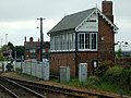
Opened in 1857, Sleaford railway station's original building is in ashlar and spans one-and-a-half storeys and four bays. There are four gables on the street side, each decorated and housing windows. The front has a projecting portion in the centre (originally incorporating an entrance); there is another projecting portion of the frontage to the right. On the ground floor are four windows, the one on the right being a large bay window. This first building was extended on either side in 1882 with brick wings, each with eight windows. The left side includes a staircase block leading to a wood and iron bridge over the tracks. The platforms are sheltered by wooden canopies supported by elaborate columns. There is a wooden building housing waiting rooms on one of the platforms.
A stone house spanning two storeys, Bristol Farmhouse has a slate roof. There are two dormers on the front and a gabled projecting wing. Some of the windows are 17th-century, but others are 19th-century.
A two-storey house in coursed rubble with a slate roof. There are three dormers on the front and a canted bay window spanning both storeys. The listing includes the garden wall and notes that the house was "extensively" altered in the mid 19th century.
A two-storey building in coursed rubble with a tile roof and brick quoins. The front facing the road has two gables each with a window on both floor. These houses were previously numbered 12 and 13.
A pair of two-storey cottages made of rubble with quoins and tile roofs. There are two gabled wings facing the road. These houses were previously numbered 8 and 9.
A range of three-storey brick buildings with pantile roofs.[236] No 2 was the Rose and Crown public house until it closed in 2015; it reopened in 2018 under new owners as the Watergate Yard public house.[237][238] It is rendered and has a flat-arched entry way to a rear yard.[236] The Rose and Crown had occupied that site since at least 1835, backing onto a pub of the same name on Westgate.[229] No 10 has a separate design from the rest of the range and an arched passageway leading to the rear.[236]
This is a three-story, rendered building with brick sides; there are 3 windows on each of the middle and ground floors (the middle windows being filled in) above a modern ground floor.
This is a pair of terraced buildings across two storeys; along the roof are three dormers. No 12 is rendered and has two modern canted oriel windows on the first floor and a modern ground floor. No 14's brickwork is painted and has two windows on the first floor and a 19th-century shop front on the ground floor.
15 Westgate is a three-storeyed brick building with three windows upstairs, above a 19th-century shopfront and an arched passage entry on the right side of the building.
A painted brick pair of buildings, Nos 16 and 18 span two storeys and have pantile roofs with a dormer on each building. There is one window on each of the upper floors above a 19th-century shopfront to No 16 and a modern ground floor front to No 18.
A painted brick building spanning two stories, 17 Westgate's pantile roof incorporates two dormers. Its upper floor has two windows, while the ground floor has a 19th-century shop front.
This is a three-storey brick building with two windows and a passage on the left side. When it was listed in 1974, there was a sign on the building indicating that it used to be a temperance hotel.
A neo-Gothic design in red brick with a slate roof, 20b Westgate spans two storeys. The front facing the road has an arched Gothic window upstairs and a Georgian-style window downstairs; the side has two windows on each floor and an arched doorway on the ground level, with a single-storey extension continuing to the rear.
Spanning two storeys, 22 Westgate is a brick house with a slate roof. There is a bay window and a doorway with pilasters surrounding it on the ground floor, and three windows upstairs.
A two-storey building in painted brick, the lower floor has a single window and a doorway with a fanlight and a pilastered surround; the upper floor has two windows.
The building is of the late 18th or early 19th century, but the side facing the street is mid-19th-century. Of three storeys, the rear (made of ashlar) spans five bays across its upper two floors above a ground floor composed of two bow windows either side of a doorway with Tuscan columns and steps leading down to the house's gardens. On the street front, there are three windows on the upper floors; a central doorway sits between two windows on the ground level. There is a rendered two-storey wing to the left of the rear frontage.[253]
The house was privately occupied until 1954[n 5] before it was acquired by Sleaford Urban District Council (UDC); they used it as their offices and hosted their council chamber there until the UDC was abolished in 1974, when the building was taken over by North Kesteven District Council and used as their register office. In 1985, Anglian Water purchased the house.[254] The house has been in private ownership since Anglian Water sold it in 1995.[258][n 7]
A brick building with a pantile roof, this house has two windows facing the street on the upper floor and two windows on the ground floor between a door with a pilastered surround in a Georgian style.
A terraced pair of brick buildings across three storeys with a pantile roof and a stone plinth along the base. Each has shop front on the ground level and a window facing the street on the upper floor. There is a passageway on the west side of No 32.
A brick house spanning three storeys, the middle and upper floors each have three windows; the ground floor has two windows either side of doorway with a fanlight. When the building was listed in 1974, there was a shopfront on the right side of the ground floor, but this had been replaced by a window by the time No 34 was photographed for English Heritage in 2001.
This two-storey building is rendered with a modern roof. On the front, there are two ground-floor bow windows between a centre door which is under a pediment. On the upper floor, there are two windows.
These 18th-century brick buildings span three storeys and each include one bay on the middle and upper floors. Their fronts have been rendered and include a 19th-century ground-floor extension with shop windows and pointed arches in front of their doorways. In the middle of the pair, there is an arched passage to the rear.[268] The building was built by Thomas Fawcett in 1802 and served as the Wesleyan Methodist Chapel until 1846.[267]
A playhouse, this coursed-stone, two-storey building dates to the early 19th century. It has a Welsh slate roof. On the first floor, there are two windows to the front of the building and four to the side.[270]
Travelling actors are known to have performed in Sleaford in the late 18th century and eventually put on regular shows. In 1825, the comedian Joseph Smedley built this playhouse, though performances were limited to a few weeks a year and the building was let for storage for the rest of the time. Smedley's retirement in 1841 was followed by a period of declining fortunes for the theatre (possibly connected to Westgate's development as a slum district). It closed in 1855, after which Kirk and Parry converted the building into Sleaford's National School (opened in 1856); the now-demolished Corn Exchange opposite the Market Place (which opened in the 1850s) became host to the town's theatrical productions.[269] The school, catering for infants, eventually closed and the building served as a library and an office building. In 1994, it was purchased by Sleaford Little Theatre, who converted it for use as a theatre. Having reopened in 2000, it continues to host regular productions.[271]
↑New Sleaford, Old Sleaford, Quarrington and Holdingham parishes were part of Sleaford Urban District from 1894 until urban districts were abolished in 1974.[4] The Local Government (Successor Parishes) Order 1973 merged all four parishes into one new successor civil parish called Sleaford after the urban district was abolished.[5]
↑When the building was listed in 1974, this was still used as a doorway, but photographs uploaded to the entry's web listing show that by 2024 this door had been converted into a window.[146]
↑The list entry says the building was completed in 1834,[187] though the school's historian Charles Ellis gives an opening date for the new school of 1 September 1835.[188]
↑The mill sits in a car park called Money's Yard, the eastern part of which had been occupied by the warehouses and offices of the seed merchant John Money in the 19th century; these were cleared in 1979 to make way for the car park, as was the site of Gladstone's Yard to the west, a coal yard and series of tenements built c. 1823 and demolished in 1959.[213]
↑According to a report in the Sleaford Standard, the building was owned by William Hungerford Holdich (d. 1880),[254] a partner in Messrs W. H. and C. W. Holdich, a firm of solicitors.[255] It was then occupied by William Henry Knight (1832–1886), a partner in Kirk and Parry who managed the firm after Parry's death in 1879;[256] His widow Eliza died at the house in 1906.[257] The house was subsequently occupied by Dr Charles Woods from 1909 to 1919, John T. Sharpe from 1919 to 1920, Dr John Cooper from 1920 to 1933, and then Dr Joseph Elison Eadham from 1933 until his death in 1953; Eadham's son sold it to Sleaford Urban District Council in 1954.[254]
↑ECS merged with several companies in 2007 to form Qube,[260] which was bought by MRI Software in 2017.[259][261]
↑Anglian Water sold it to Estate Computer Systems in 1995;[258]MRI Software (ECS's successor company) departed in 2021[259][n 6] and Holton Sleaford Independent School, a private school, has occupied the building from 2022.[262]
↑See Mahany & Roffe 1979, pp.11–14 for the main argument that a church existed in New Sleaford at by the time the Domesday Book was compiled in c. 1086.
Brand, Anthony; Pawley, Simon (2024), Celebrating Fifty(PDF), Sleaford: Sleaford Town Council, archived from the original(PDF) on 22 May 2024
Edmonds, Kate; Venn, Elizabeth (1977), A School Remembers: Kesteven and Sleaford High School 1902–1977, Sleaford: Kesteven and Sleaford High School, OCLC872093985
Ellis, C. W. R. (1954), Carre's Grammar School: 1604–1954, Sleaford: W.K. Morton & Sons, OCLC40597553
Mahany, Christine; Roffe, David (1979), Sleaford, Stamford: South Lincolnshire Archaeological Unit, ISBN978-0-906295-02-1
Old Sleaford Heritage Group (2020), Old Sleaford, New Perspectives: A History of the Manor House of Old Sleaford, Lincolnshire, Sleaford: Old Sleaford Heritage Group, ISBN978-1-5272-6392-5
Pawley, Simon (1996), The Book of Sleaford, Finmere: Baron Birch for Quotes Ltd., ISBN978-0-86023-559-0
Sleaford and District Civic Trust (2009), Sleaford Historic Buildings(PDF), Sleaford: Sleaford and District Civic Trust, archived from the original(PDF) on 10 May 2021
This page is based on this Wikipedia article Text is available under the CC BY-SA 4.0 license; additional terms may apply. Images, videos and audio are available under their respective licenses.