Little Dry Run Wilderness

Last updated
Little Dry Run Wilderness
Looking south into mountains in Little Dry Run Wilderness Area from State Route 749 near Speedwell Va.jpg
Looking south into mountains in vicinity of Little Dry Run Wilderness Area from State Route 749 near Speedwell Va
USA Virginia relief location map.svg
Red pog.svg
Location Wythe County Virginia, United States
Nearest city Wytheville, Virginia
Coordinates 36°47′09″N81°12′42″W / 36.78575°N 81.21154°W / 36.78575; -81.21154
Area2,858 acres (1,157 ha)
Established1984
Administrator U.S. Forest Service

The Little Dry Run Wilderness is an area in the Mount Rogers National Recreation Area protected by the Eastern Wilderness Act of Congress to maintain its present, natural condition. As part of the wilderness system, it is intended to preserve a variety of natural life forms and contribute to a diversity of plant and animal gene pools. Over half of the ecosystems in the United States exist within designated wilderness. [1]

Contents

Named after Little Dry Run, a stream lined with hemlocks and white pines that runs through the center of the wilderness, the area has good hikes far removed from the busy west side of the Mount Rogers Recreation Area: [2] which is part of the Mount Rogers Cluster .

Location and access

The wilderness is located at the east end of Mount Rogers Recreation Area. near the town of Speedwell in Wythe County. [2] It is bounded on the east by US 21, and on the south and west by the Virginia Highlands Horse Trail. The northern boundary is about 1 mile south of VA 612. [3]

There is one maintained trail, the Little Dry Run Trail, Forest Service Trail #305, with a few yellow blazes, 4.4 miles long, and moderately difficult with trailheads on US 21 at the eastern end of the trail, and Comers Rock Campground on the west. [4] [3] [5]

The Virginia Highlands Horse Trail borders the wilderness on the southern side. [3]

The Virginia Highlands Extension extends from the Horse Trail for four miles to a ridgetop. [6]

The Ridge Top Area Bushwhack is a 4-mile hike beginning at the junction of Little Dry Run Trail and the Virginia Highlands Trail. [6]

Natural history

Dry Run, near Little Dry Run Wilderness on State Route 21, south of Speedwell, Virginia Dry Run, near Little Dry Run Wilderness on State Route 21, south of Speedwell, Virginia.jpg
Dry Run, near Little Dry Run Wilderness on State Route 21, south of Speedwell, Virginia

With different habitats, the wilderness is home to a large variety of species. In the spring, wood anemone, false Solomon’s seal, foamflower, mayapple, large-flowered trillium, red trillium, and Solomon's seal are seen. [2] [7]

Bird species include worm-eating warblers, black and white warblers, golden crowned kinglets, eastern wood pewees and pine warblers. [2] Eastern redbud, Frazer magnolia, witch-hazel and mountain maple provide dense cover for nesting birds such as the wood thrush, summer tanager, red-eyed vireo and ovenbird. [7]

Cove forests contain white bass-wood, tulip poplar, sugar maple, white ash and eastern hemlock. The wilderness is in an area that contains the rare round-leaf birch. [7] Remnants of old growth forest are found near Sindion Point. [2]

Little Dry Run is a native trout stream. [8]

Topography

Crigger Creek carrying drainage from Little Dry Run Wilderness, along Crigger Creek Road near Speedwell, Va Crigger Creek carrying drainage from Little Dry Run Wilderness, along Crigger Creek Road near Speedwell, Va.jpg
Crigger Creek carrying drainage from Little Dry Run Wilderness, along Crigger Creek Road near Speedwell, Va

The watershed of Little Dry Run, completely enclosed in the wilderness, begins with a small bog, then descends to join Dry Run which flows north along the eastern side of the wilderness. [9] Two rivers flow along the wilderness’ boundary—Jones Creek on the northwest and West Dry Run Fork on the south. [2]

Elevations range from 2440 feet along Little Dry Run to a 3614 feet at an unnamed peak. [8] A small knob on the northwest corner of the wilderness, Sindion Point, elevation 3018 feet, stands at the end of a ridge running through the wilderness. [9] [10]

Nearby Comers Rock, outside the wilderness on the south, with an elevation of 4102 feet, has an observation platform offering views of the surrounding countryside. [11]

The wilderness is part of the Blue Ridge Province which is distinct from the Ridge and Valley Province to the west. [2]

Management

Designated by Congress in 1984 with a total of 2845 acres, the wilderness is managed by the Forest Service through the Mount Rogers National Recreation Area. [4]

There are some regulations to maintain the integrity of the area as a wilderness. For example, motorized equipment, motor vehicles and mountain bikes are prohibited, group size is limited to ten people, and limits are placed on camping. [8]

See also

Related Research Articles

<span class="mw-page-title-main">Mount Rogers</span> Highest point in Virginia, United States

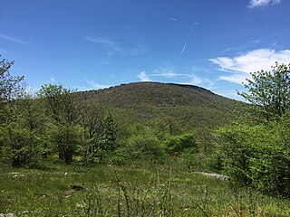
Mount Rogers is the highest natural point in Virginia, United States, with a summit elevation of 5,729 feet (1,746 m) above mean sea level. The summit straddles the border of Grayson and Smyth Counties, Virginia, about 6.45 miles (10.38 km) WSW of Troutdale, Virginia. Most of the mountain is contained within the Lewis Fork Wilderness, while the entire area is part of the Mount Rogers National Recreation Area, which itself is a part of the Jefferson National Forest.

<span class="mw-page-title-main">Mount Rogers National Recreation Area</span>

Mount Rogers National Recreation Area is a United States national recreation area (NRA) in southwestern Virginia near the border with Tennessee and North Carolina. It centerpiece is the Lewis Fork Wilderness containing Mount Rogers, the highest point in the state of Virginia with a summit elevation of 5,729 feet. The recreation area is under the jurisdiction of the George Washington and Jefferson National Forests. The recreation area was established by an act of the United States Congress on May 31, 1966.

Mountain Lake Wilderness is a U.S. Wilderness Area in the George Washington and Jefferson National Forests. The wilderness area is located next to privately owned Mountain Lake, and consists of 8,314 acres (3,365 ha) in Virginia and 2,721 acres (1,101 ha) in West Virginia.

<span class="mw-page-title-main">Barbours Creek Wilderness</span>

Barbours Creek Wilderness is a U.S. wilderness area in the Eastern Divide Ranger District of George Washington and Jefferson National Forests of western Virginia, United States. The wilderness area was established in 1988 and consists of 5,382 acres (2,178 ha) of forests in the Appalachian Mountains ranging in elevation from 1,700 to 3,800 feet.

<span class="mw-page-title-main">Beartown Wilderness</span> Protected area in Virginia, US

Beartown Wilderness is a U.S. wilderness area in the Eastern Divide Ranger District of the George Washington and Jefferson National Forests. The Wilderness consists of 5,613 acres (22.72 km2) of land with elevations ranging from 2,400 to 4,800 feet. It was created from existing National Forest lands in 1984 by the Virginia Wilderness Act of 1984.

<span class="mw-page-title-main">Garden Mountain Wilderness</span> Protected area in Virginia, US

Garden Mountain Wilderness is a U.S. wilderness area in the Eastern Divide Ranger District of the George Washington and Jefferson National Forests. It is a small wilderness area in western Virginia, consisting of an area of 3,331 acres (13.48 km2) and bordering the Beartown and Hunting Camp Creek Wilderness. It was designated as wilderness area in 2009 by Omnibus Public Land Management Act of 2009. The wilderness area also borders a portion of the Appalachian Trail.

<span class="mw-page-title-main">Brush Mountain East Wilderness</span> Protected area in Virginia, US

Brush Mountain East Wilderness is a U.S. wilderness area in the Eastern Divide Ranger District of the George Washington and Jefferson National Forests. It was designated as wilderness area in 2009 by Omnibus Public Land Management Act of 2009. The wilderness is adjacent to Brush Mountain Wilderness.

<span class="mw-page-title-main">Thunder Ridge Wilderness</span> Federally-protected natural area located outside Buena Vista, Virginia

The Thunder Ridge Wilderness is a 2,344 acres (949 ha) area located near Natural Bridge, Virginia, which is protected by the Eastern Wilderness Act of Congress to maintain its present, natural condition. As part of the National Wilderness Preservation System, it helps to preserve a variety of natural life forms and contributes to a diversity of plant and animal gene pools. Over half of the ecosystems in the United States exist within designated wilderness.

<span class="mw-page-title-main">Shawvers Run Wilderness</span>

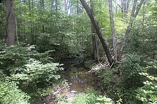
The Shawvers Run Wilderness, a 5784-acre area located less than one mile south of Potts Creek, Virginia, is protected by the Eastern Wilderness Act of Congress to maintain its present, natural condition. As part of the National Wilderness Preservation System, it helps to preserve a variety of natural life forms and contributes to a diversity of plant and animal gene pools. Over half of the ecosystems in the United States exist within designated wilderness.

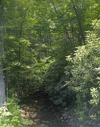
The Hunting Camp Creek Wilderness is an area protected by the Eastern Wilderness Act of Congress to maintain its present, natural condition. As part of the wilderness system, it helps to preserve a variety of natural life forms and contributes to a diversity of plant and animal gene pools. Over half of the ecosystems in the United States exist within designated wilderness.

The Raccoon Branch Wilderness is an area in the Mount Rogers National Recreation Area protected by the Eastern Wilderness Act of Congress to maintain its present, natural condition. As part of the wilderness system, it is intended to preserve a variety of natural life forms and contribute to a diversity of plant and animal gene pools. Over half of the ecosystems in the United States exist within designated wilderness.

The Little Wilson Creek Wilderness is an area in the Mount Rogers National Recreation Area protected by the Eastern Wilderness Act of Congress to maintain its present, natural condition. As part of the wilderness system, it is intended to preserve a variety of natural life forms and contribute to a diversity of plant and animal gene pools. Over half of the ecosystems in the United States exist within designated wildernesses.

<span class="mw-page-title-main">Lewis Fork Wilderness</span>

The Lewis Fork Wilderness is an area in the Mount Rogers National Recreation Area protected by the Eastern Wilderness Act of Congress to maintain its present, natural condition. As part of the wilderness system, it is intended to preserve a variety of natural life forms and contribute to a diversity of plant and animal gene pools. Over half of the ecosystems in the United States exist within designated wilderness.

Horse Heaven is a wildland in the George Washington and Jefferson National Forests of western Virginia, United States, that has been recognized by the Wilderness Society as a special place worthy of protection from logging and road construction. The Wilderness Society has designated the area as a "Mountain Treasure".

Little Dry Run Wilderness Addition is a wildland in the George Washington and Jefferson National Forests of western Virginia that has been recognized by the Wilderness Society as a special place worthy of protection from logging and road construction. The Wilderness Society has designated the area as a "Mountain Treasure".

<span class="mw-page-title-main">Mount Rogers Crest Zone</span>

Mount Rogers Crest Zone is a wildland in the George Washington and Jefferson National Forests of western Virginia that has been recognized by the Wilderness Society as a special place worthy of protection from logging and road construction. The Wilderness Society has designated the area as a "Mountain Treasure".

<span class="mw-page-title-main">Whitetop Mountain (conservation area)</span> Protected area in Virginia, USA

Whitetop Mountain (conservation area) is a wildland in the George Washington and Jefferson National Forests of western Virginia that has been recognized by the Wilderness Society as a special place worthy of protection from logging and road construction. The Wilderness Society has designated the area as a "Mountain Treasure".

<span class="mw-page-title-main">Mount Rogers Cluster</span> Protected natural area in Virginia, United States

The Mount Rogers Cluster is a region recognized by The Wilderness Society for its unique high elevation mountains, vistas, trout streams and wildlife habitat. The heart of the region is Mount Rogers, the highest mountain in Virginia. The area extends over the Mount Rogers National Recreation Area and into part of the Cherokee National Forest.

Hoop Hole, a wildland in the George Washington and Jefferson National Forests of western Virginia, has been recognized by the Wilderness Society as a special place worthy of protection from logging and road construction. The Wilderness Society has designated the area as a "Mountain Treasure".

The Barbours Creek-Shawvers Run Cluster is a region in the Jefferson National Forest recognized by The Wilderness Society for its unique high elevation mountains, vistas, trout streams and wildlife habitat. With over 25,000 acres in a remote corner of the national forest, the cluster provides protection for black bear, clean water, backcountry hiking, and scenic beauty.

References

  1. Wilderness.org: Why Wilderness? | Wilderness.org, accessdate: May 14, 2017
  2. 1 2 3 4 5 6 7 Bamford, Sherman (October 2014). 18 Wonders of Virginia. Richmond, Virginia: Sierra Club Virginia Chapter. pp. 50–53. ISBN   978-0-926487-79-6.
  3. 1 2 3 National Geographic Map: Mount Rogers National Recreation Area [Jefferson National Forest], accessdate: May 14, 2017
  4. 1 2 Carroll, Steve; Miller, Mark (2002). Wild Virginia, A Guide to Thirty Roadless Recreation Areas including Shenandoah National Park. Guilford, Connecticut: Globe Pequot Press. pp. 127–130. ISBN   0-7627-2315-7.
  5. Molloy, Johnny (2001). Mount Rogers, Outdoor Recreation Handbook. Birmingham, Alabama: Menasha Ridge Press. pp. 161–162. ISBN   0-89732-328-9.
  6. 1 2 Steven Carroll and Mark Miller (1995). Wilderness Virginia. Lexington, Virginia: Old Forge Productions. pp. 96–105. ISBN   0-9646692-1-8.
  7. 1 2 3 Winegar, Deane and Garvey (1998). Highroad Guide to the Virginia Mountains . Marietta, Georgia: Longstreet Press, Inc. pp.  247. ISBN   1-56352-462-7.
  8. 1 2 3 General Information: Wilderness.net - Little Dry Run Wilderness - General Information, accessdate: May 14, 2017
  9. 1 2 Virginia Wilderness Committee: Little Dry Run Wilderness - Virginia Wilderness Committee, accessdate: May 15, 2017
  10. "Geographic Names Information System (GNIS)" . Retrieved 15 May 2017.
  11. Horan, Jack (1997). Where Nature Reigns, The Wilderness Areas of the Southern Appalachians. Asheboro, North Carolina: Down Home Press. pp. 178–179. ISBN   1-878086-58-8.