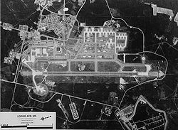
Loring Air Force Base | |
---|---|
Coordinates: 46°56′59″N67°53′2″W / 46.94972°N 67.88389°W Coordinates: 46°56′59″N67°53′2″W / 46.94972°N 67.88389°W | |
Country | United States |
State | Maine |
County | Aroostook |
Area | |
• Total | 8.2 sq mi (21.3 km2) |
• Land | 7.8 sq mi (21.2 km2) |
• Water | 0.4 sq mi (0.1 km2) |
Elevation | 746 ft (227.4 m) |
Population (2000) | |
• Total | 225 |
• Density | 27.4/sq mi (10.6/km2) |
Time zone | UTC-5 (Eastern (EST)) |
• Summer (DST) | UTC-4 (EDT) |
ZIP code | 04750 |
Area code(s) | 207 |
FIPS code | 23-41260 |
Loring Air Force Base is a former census-designated place (CDP) in the town of Limestone in Aroostook County, Maine, United States. It was the site of Loring Air Force Base, at one time the largest base for the U.S. Air Force's Strategic Air Command. The population of the CDP was 225 at the 2000 census. It was not counted during the 2010 census.
The Loring Air Force Base CDP was located at 46°56′59″N67°53′20″W / 46.94972°N 67.88889°W . [1]
According to the United States Census Bureau, the CDP had a total area of 8.2 mi2 (21.3 km2). 8.2 mi2 (21.3 km2) of it was land and 0.04 mi2 (0.1 km2) of it (0.36%) was water.
Historical population | |||
---|---|---|---|
Census | Pop. | %± | |
1970 | 6,266 | — | |
1980 | 6,572 | 4.9% | |
1990 | 7,829 | 19.1% | |
2000 | 225 | −97.1% | |
source: [2] [3] [4] |
As of the census [5] of 2000, there were 225 people, 82 households, and 57 families residing on the base. The population density was 27.4/mi2 (10.6/km2). There were 355 housing units at an average density of 43.2/mi2 (16.7/km2). The racial makeup of the base was 81.33% White, 10.22% African American, 2.22% Asian, 5.33% from other races, and 0.89% from two or more races. Hispanic or Latino of any race were 13.78% of the population.
There were 82 households, out of which 53.7% had children under the age of 18 living with them, 54.9% were married couples living together, 11.0% had a female householder with no husband present, and 29.3% were non-families. 28.0% of all households were made up of individuals, and 1.2% had someone living alone who was 65 years of age or older. The average household size was 2.74 and the average family size was 3.38.
On the base the population was spread out, with 37.3% under the age of 18, 5.3% from 18 to 24, 43.6% from 25 to 44, 10.7% from 45 to 64, and 3.1% who were 65 years of age or older. The median age was 29 years. For every 100 females, there were 90.7 males. For every 100 females age 18 and over, there were 93.2 males.
The median income for a household on the base was $36,667, and the median income for a family was $39,844. Males had a median income of $33,125 versus $25,724 for females. The per capita income on the base was $19,888. None of the families and 5.0% of the population were below the poverty line, including none of those under the age of 18 or ages 65 and older.
Salamatof is a census-designated place (CDP) in Kenai Peninsula Borough, Alaska, United States. The population was 1,078 at the 2020 census, up from 980 in 2010. Salamatof is the location for the former Wildwood Air Force Station, which operated from 1965 to 1972. Today, it is the Wildwood Correctional Complex.
Mojave Ranch Estates is a census-designated place (CDP) in Mohave County, Arizona, United States. The population was 28 at the 2000 census.
Homestead Base is a census-designated place (CDP) in Miami-Dade County, Florida, United States. The population was 446 at the 2000 census.
Cudjoe Key is a census-designated place and unincorporated community in Monroe County, Florida, United States, on an island of the same name in the lower Florida Keys. As of the 2000 census, the CDP had a total population of 1,695.
Gun Club Estates is a census-designated place (CDP) in Palm Beach County, Florida, United States. The population was 816 at the 2020 census. The CDP is located in an unincorporated area near the southwest corner of the Palm Beach International Airport (PBI) and is bounded by West Palm Beach Canal on the north, Kirk Road on the east, Gun Club Road on the south, and Military Trail on the west.
Forestdale is a village and census-designated place (CDP) within the town of Sandwich in Barnstable County, Massachusetts, United States. The population of Forestdale was 4,099 at the 2010 census. It is the most populous of the three CDPs in Sandwich. The ZIP code of Forestdale is 02644.
The village of Pocasset is a census-designated place (CDP) in the town of Bourne in Barnstable County, Massachusetts, United States, located on Buzzards Bay. The population was 2,851 at the 2010 census.
Parc is a location and census-designated place in Clinton County, New York, United States. The name "Parc" is derived from the official name for the 3,447-acre (13.95 km2) industrial site, which is PARC, an acronym for the Plattsburgh Airbase Redevelopment Corporation. PARC was established for the purpose of redeveloping the Plattsburgh Air Force Base after it closed on September 25, 1995. PARC is now operated by the Plattsburgh Air Base Development Authority, and the massive airfield is now Plattsburgh International Airport. The population of the Parc CDP was 254 at the 2010 census. Parc is located in the town of Plattsburgh and is bordered to the north by the city of Plattsburgh.
Woodbourne is a census-designated place (CDP) in Bucks County, Pennsylvania, United States. The population was 3,851 at the 2010 census.
Irwin Township is a township in Venango County, Pennsylvania, United States. The population was 1,309 at the 2000 census.
Reese Center is an unincorporated community and former census-designated place (CDP) in Lubbock County, Texas, United States. The population was 42 at the 2000 census. Its population was not recorded separately for the 2010 census. It is part of the Lubbock Metropolitan Statistical Area.
Merrifield is a census-designated place (CDP) in Fairfax County, Virginia, United States. The population was 15,212 at the 2010 census.
Moses Lake North is a census-designated place (CDP) in Grant County, Washington, United States. The population was 4,050 at the 2020 census.
Lake Stickney is a census-designated place (CDP) in Snohomish County, Washington, United States. The population was 7,777 at the 2010 census. The CDP was known as Paine Field-Lake Stickney prior to 2010. The new Lake Stickney CDP no longer contains the Paine Field airport.
West Brookfield is a census-designated place (CDP) in the town of West Brookfield in Worcester County, Massachusetts, United States. The population was 1,413 at the 2010 census.
Hickam Housing is a census-designated place comprising part of Joint Base Pearl Harbor-Hickam in the City & County of Honolulu, Hawaii, United States. The population was 7,581 at the 2020 census. The CDP occupies the area that was formerly Hickam Air Force Base.
Bangor Base is a census-designated place (CDP) in Kitsap County, Washington, within U.S. Naval Base Kitsap on the Kitsap Peninsula. Its population was 6,054 at the 2010 census.
Limestone is a town in Aroostook County, Maine, United States. The population was 1,526 at the 2020 census.
Grand Forks Air Force Base is a census-designated place (CDP) in Grand Forks County, North Dakota, United States. It corresponds to Grand Forks Air Force Base, a United States Air Force installation. As of the 2020 census, the CDP had a population of 2,002.
Andrews Air Force Base is a census-designated place (CDP) covering the residential population of Andrews Air Force Base/Joint Base Andrews, in Prince George's County, Maryland, Maryland, United States. The population at the 2020 Census was 3,025.