Lower Clapton's unusual Round Chapel. Built in 1869–71 as a Congregational church, it is now an arts centre. It is considered to be one of the finest non-conformist buildings in London.
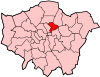
The London Borough of Hackney is a London Borough in Inner London, United Kingdom. The historical and administrative heart of Hackney is Mare Street, which lies 5 miles (8 km) north-east of Charing Cross. The borough is named after Hackney, its principal district.
England is a country that is part of the United Kingdom. It shares land borders with Wales to the west and Scotland to the north. The Irish Sea lies west of England and the Celtic Sea to the southwest. England is separated from continental Europe by the North Sea to the east and the English Channel to the south. The country covers five-eighths of the island of Great Britain, which lies in the North Atlantic, and includes over 100 smaller islands, such as the Isles of Scilly and the Isle of Wight.
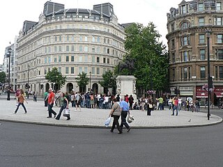
Charing Cross is a junction in London, England, where six routes meet. Clockwise from north these are: the east side of Trafalgar Square leading to St Martin's Place and then Charing Cross Road; the Strand; Northumberland Avenue; Whitehall; The Mall leading to Admiralty Arch and Buckingham Palace; and two short roads leading to Pall Mall.
Lower Clapton can be described as closely approximating to the southern part of the E5 (Clapton) postal district.
History
Clapton was from 1339 until the 18th century normally rendered as Clopton, meaning the "farm on the hill". The Old English clop - "lump" or "hill" - presumably denoted the high ground which rises from the River Lea. Clapton grew up as a straggling hamlet along the road subsequently known as Lower and Upper Clapton Road, and as the area became urbanised, the extent of the area called Clapton eventually increased to encompass most of the north-eastern quarter of the Ancient Parish and subsequent Metropolitan Borough of Hackney.
Hackney was a parish in the historic county of Middlesex. The parish church of St John-at-Hackney was built in 1789, replacing the nearby former 16th-century parish church dedicated to St Augustine. The original tower of that church was retained to hold the bells until the new church could be strengthened; the bells were finally removed to the new St John's in 1854. See details of other, more modern, churches within the original parish boundaries below.
The Metropolitan Borough of Hackney was a Metropolitan borough of the County of London from 1900 to 1965. Its area became part of the London Borough of Hackney.
As described, the settlement emerged along the way which in 1745 was called Hackney Lane, part of which ran through Broad (later Clapton) Common. Building spread to meet streets east of the high road and north of Homerton in the 19th century. Manorial courts (the Manor of Lordship) from the early 19th century distinguished the parts north and south of Lea Bridge Road as Upper and Lower Clapton, and those names soon passed into general use. Hackney Lane came to be known as Lower and Upper Clapton roads, until in the late 19th century the stretch through the common to Stamford Hill was named Clapton Common.[2]
Homerton is a district in London, England, in the London Borough of Hackney. It was a suburb of the metropolitan area of London until 1965 when it was reformed and expanded. It is bordered to the west by Hackney Central, to the north by Lower Clapton, in the east by Hackney Wick, Leyton and by South Hackney to the south.
Governance
As of 2014, Lower Clapton is represented by five separate electoral wards. Each of these wards straddles the boundaries between Lower Clapton and its neighbours.
A map showing the Clapton Park ward of Hackney Metropolitan Borough as it appeared in 1916.
Lower Clapton is split between two parliamentary constituencies: Hackney North and Stoke Newington, and Hackney South and Shoreditch.
Geography
Lower Clapton closely approximates to the southern part of the E5 (Clapton) postal district and as such can be described as having the following approximate boundaries:
Lea Bridge Road is a major through route in east London, across the Lea Valley from Clapton to Whipps Cross in Leyton. It forms part of the A104 road.
Upper Clapton is a district in the London Borough of Hackney, forming part of Clapton in northeast London, England.
Manorial courts from the early 19th century distinguished the parts of Clapton north and south of Lea Bridge Road as Upper and Lower Clapton, and those names soon passed into general use.
South: The southern boundary approximates to Clifden Road.
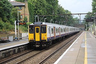
Rectory Road is a London Overground station on the Lea Valley Lines in the West Hackney area of the London Borough of Hackney, east London.
Hackney Downs is a London Overground and National Rail station in Hackney Central and serves the old common land of Hackney Downs in Lower Clapton in the London Borough of Hackney, it is on the Lea Valley Lines and West Anglia Main Line. It is 2 miles 78 chains (4.8 km) down the line from London Liverpool Street and has a direct passenger link to Hackney Central station, providing interchange with the North London Line of the Overground network
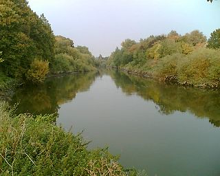
The Lea Valley, the valley of the River Lea, has been used as a transport corridor, a source of sand and gravel, an industrial area, a water supply for London, and a recreational area. The London 2012 Summer Olympics were based in Stratford, in the Lower Lea Valley. It is very important for London's water supply, as the source of the water transported by the New River aqueduct, but also as the location for the Lee Valley Reservoir Chain, stretching from Enfield through Tottenham and Walthamstow.
Open Spaces and Urban Fabric
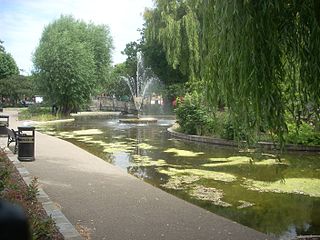
Lower Clapton is centred on Lower Clapton Road, to the north of which is Clapton Pond, the remnant of the old village green.
Clapton Pond is a pond and garden at Clapton in the London Borough of Hackney.
A village green is a common open area within a village or other settlement. Traditionally, a village green was common grassland at the centre of a rural settlement used for grazing with a pond for watering cattle and other stock.
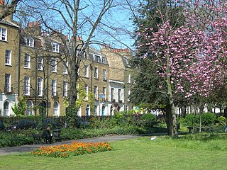
Clapton Pond and the late GeorgianClapton Square are the area's two major conservation zones. Clapton Square is an attractive Conservation area which includes historic Georgian terraces facing onto the parkland in the centre of the Square.
Hackney Downs, one of the larger open spaces in Hackney, is formally within this district, though many people consider the Downs to be an area of Hackney in its own right.
Lower Clapton has a relatively large amount of green space for a district of inner London. In addition to Hackney Downs, the area is bordered by Millfields Park, Clapton Park, and Hackney Marshes.
Clapton Pond – the old village green. (September 2005)
Large parts of Lower Clapton look much as they did when the area was first developed in the second half of the 19th century. Most of the housing stock consists of Victorian terraces of various sizes. Several highrise LPS constructions erected by the Council in the late 1960s and early 1970s were demolished in the 1990s to make way for lowrise Local Authority housing, e.g. the Clapton Park Estate.
Social Fabric
Like many other parts of East London, Lower Clapton is socially diverse and multicultural. Chatsworth Road, which had a regular market until the 1990s, still provides many amenities for people who live in the area. A new Sunday market has been established there since December 2010. The shops and restaurants on Chatsworth Road reflect the diversity of the surrounding streets – offering African, Turkish, Asian and Caribbean produce alongside butchers, bakers and greengrocers. More recent additions include a creperie, coffee shops and a French delicatessen, part of the area's vaunted gentrification in the lead-up to the 2012 Olympic Games.
Transport
Lower Clapton doesn't contain any railway stations but there are a number close by, including:
Clapton F.C. was the original local football team, being formed in 1878. Leyton Orient, founded in 1881 also played in the area before moving to Leyton in 1937.
A number of shootings that took place in the 1990s and early 2000s on Upper and Lower Clapton Road earned the locality the nickname "Murder Mile".[4] During the 2011 England riots, Clarence Road, near the epicentre of the rioting, was the site of Pauline Pearce's Heroine of Hackney speech.[5]
Related Research Articles
Leyton is a district of east London and part of the London Borough of Waltham Forest, located 6.2 miles (10 km) north-east of Charing Cross in the United Kingdom. It borders Walthamstow and Leytonstone in Waltham Forest, Stratford in the London Borough of Newham and Homerton and Lower Clapton in the London Borough of Hackney. The district includes part of the Queen Elizabeth Olympic Park, which hosted the 2012 Olympic Games, as well as Leyton Orient Football Club, although it is predominantly residential. It consists mainly of terraced houses built between 1870 and 1910, interspersed with some modern housing estates.
Hackney Marshes is an area of open space in London's Lower Lea Valley, lying on the western bank of the River Lea. It takes its name from its position on the eastern boundary of Hackney, the principal part of the London Borough of Hackney, and from its origin as an area of true marsh.
Hackney Central is a sub-district of Hackney in the London Borough of Hackney in London, England and is four miles northeast of Charing Cross.
The Hackney Brook is one of the subterranean rivers of London. It crossed the northern parts of the current London boroughs of Hackney and Islington, emptying into the River Lea at Hackney Wick, with its source in Holloway.
Hackney South was a parliamentary constituency in "The Metropolis". It was represented by nine Members of Parliament to the House of Commons of the Parliament of the United Kingdom, only two of whom, Horatio Bottomley and Herbert Morrison, were returned.
The A102 is a road that starts in Clapton in north east London in the London Borough of Hackney and ends by merging into the A2 road just south of the Sun in the Sands roundabout in south east London in the Royal Borough of Greenwich. The A102 was formerly a continuous route including two motorway sections classified as the A102(M), but road renumbering means that it is separated into two sections linked by the A106 and the A12, one consisting of non-primary urban roads and the other a primary dual carriageway south of the river. The route includes the Blackwall Tunnel.
London Buses route 22 is a Transport for London contracted bus route in London, England. Running between Putney Common and Oxford Circus, it is operated by London General.
Clapton Square is the second largest garden square in the London Borough of Hackney, located in Lower Clapton, Clapton. It is lined by buildings on three sides. Its Conservation Area designated in 1969 – extended in 1991 and 2000 – takes in a larger green space separated by a stretch of open road: St John’s Gardens. Those gardens have the tallest and largest building visible from all parts of the square's garden, the Church of St John-at-Hackney, rebuilt in 1792-97 which contains older monuments. Two sides of the square are lined with tall, partly stone-dressed, classical, Georgian terraced houses.
Hackney is a district in East London, England. It is the administrative centre of the London Borough of Hackney, forming around two thirds of the area of the modern London Borough to which it gives its name. It is 4 miles northeast of Charing Cross.
Clapton is a district in the London Borough of Hackney, in northeast London, England. Subdivisions of Clapton are Lower Clapton and Upper Clapton. Clapton lies 5.6 miles from Charing Cross.
References
↑ "London Places"(PDF). Greater London Authority. GLA. Archived from the original(PDF) on 6 September 2015. Retrieved 11 October 2015.
↑ "Hackney 2011: the year that was". Hackney Citizen. 7 January 2012. Retrieved 17 January 2012. The Pembury Estate in Central Hackney was the epicentre of the pillaging and burning that raged down Clarence Road, Narroway and Mare Street [...]
This page is based on this Wikipedia article Text is available under the CC BY-SA 4.0 license; additional terms may apply. Images, videos and audio are available under their respective licenses.