Madera station (California High-Speed Rail)

Last updated

Madera Station
General information
Location Madera, California
Coordinates 36°55′24″N119°58′26″W / 36.923331°N 119.973833°W / 36.923331; -119.973833
Line(s) BNSF Stockton Subdivision
History
Opening2024 (Amtrak)
2030 (High-Speed Rail service)
Services
Preceding station BSicon LOGO Amtrak2.svg Amtrak Following station
Merced San Joaquins Fresno
toward Bakersfield
Preceding station California High Speed Rail.svg California High-Speed Rail Following station
Merced
Terminus
Phase I
Central Valley Segment
Fresno
towards Bakersfield
Gilroy Phase I
San Francisco Segment (2031)
Location
Relief map of California.png
Red pog.svg
Madera Station
Location within California

Madera Station is a proposed train station to serve Madera, California. It would be located near the intersection of Avenue 12 and Santa Fe Drive.

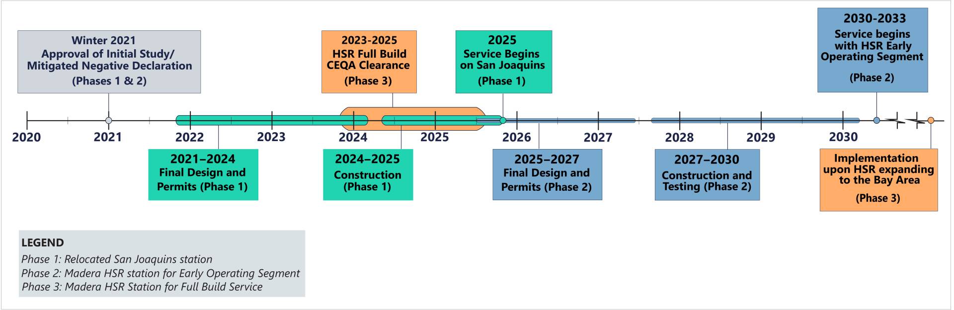
The Madera Amtrak station opened in 2010 as a replacement for the hundred-year old Storey station. The 2016 California High-Speed Rail Business Plan proposed a relocated Madera station in order to provide strong transit connectivity, potential for transit oriented development, good access to State Route 99 and the City of Madera, and connections between that system and Amtrak San Joaquins services. [1] Funding for the station was provided as part of the Valley Rail project in 2018. [2] Work on station relocation is ongoing as of November 2019, as the San Joaquin Joint Powers Authority has entered into negotiations with CAHSR, Madera County, and the city of Madera. [3] As of 2020, the new station is expected to open in 2024. [4]

Related Research Articles

<i>Pacific Surfliner</i> Intercity rail service in California, US

The Pacific Surfliner is a 350-mile (560 km) passenger train service serving the communities on the coast of Southern California between San Diego and San Luis Obispo.

<i>Capitol Corridor</i> Amtrak service between San Jose and Auburn, California

The Capitol Corridor is a 168-mile (270 km) passenger train route in Northern California operated by Amtrak between San Jose, in the Bay Area, and Auburn, in the Sacramento Valley. The route is named after the two points most trains operate between, San Jose and Sacramento. The route runs roughly parallel to I-880 and I-80. Some limited trips run between Oakland and San Jose. A single daily round trip runs between San Jose and Auburn, in the foothills of the Sierra Nevada. Capitol Corridor trains started in 1991.

<i>San Joaquins</i> Amtrak service in San Joaquin Valley, California

The San Joaquins is a passenger train service operated by Amtrak in California's San Joaquin Valley. Six daily round trips run between its southern terminus at Bakersfield and Stockton, with onward service to Sacramento and Oakland.

<span class="mw-page-title-main">Altamont Corridor Express</span> Commuter rail service in California

The Altamont Corridor Express is a commuter rail service in California, connecting Stockton and San Jose during peak hours only. ACE is named for the Altamont Pass, through which it runs. Service is managed by the San Joaquin Regional Rail Commission, and operations are contracted to Herzog Transit Services. The 86-mile (138 km) route includes ten stops, with travel time about 2 hours and 12 minutes end-to-end. In 2022, the line had a ridership of 389,100, or about 2,200 per weekday as of the second quarter of 2023. ACE uses Bombardier BiLevel Coaches, MPI F40PH-3C locomotives, and Siemens Charger locomotives.

<span class="mw-page-title-main">Amtrak California</span> Caltrans passenger rail services

Amtrak California is a brand name used by the California Department of Transportation (Caltrans) Division of Rail for three state-supported Amtrak regional rail routes in California – the Capitol Corridor, the Pacific Surfliner, and the San Joaquins – and their associated connecting network of Amtrak Thruway transportation services.

<span class="mw-page-title-main">Sacramento Valley Station</span> Railway station in Sacramento, California, US

Sacramento Valley Station is an Amtrak railway station in the city of Sacramento, California, at 401 I Street on the corner of Fifth Street. It is the seventh busiest Amtrak station in the country, and the second busiest in the Western United States. It is served by four different Amtrak train routes and connecting Amtrak Thruway motorcoaches. It is also the western terminus for the Gold Line of the Sacramento RT Light Rail system and the Route 30 bus serving Sacramento State University.

<span class="mw-page-title-main">Oakland–Jack London Square station</span> Railway station in Oakland, California, U.S.

Oakland – Jack London Square station is a train station in Jack London Square of Oakland, California, United States. The station is served by Amtrak's Capitol Corridor, Coast Starlight, and San Joaquins trains. Through Amtrak Thruway buses, this station is one of two that serves San Francisco, the other being Emeryville.

<span class="mw-page-title-main">City College station (Sacramento)</span> Light rail station in Sacramento, California, US

City College station is an at-grade light rail station on the Blue Line of the Sacramento RT Light Rail system operated by the Sacramento Regional Transit District. The station is located in an exclusive right-of-way alongside the Union Pacific Railroad's Sacramento Subdivision and a small rail yard, on the campus of Sacramento City College, after which the station is named, in the city of Sacramento, California.

<span class="mw-page-title-main">Santa Fe Passenger Depot (Fresno, California)</span> Train station in Fresno, California

The Santa Fe Passenger Depot, also known as Fresno station, is an historic railroad station and transportation hub in downtown Fresno, California. It is served by San Joaquins inter-city passenger trains, Greyhound inter-city buses, and regional transit services including Fresno Area Express and the Fresno County Rural Transit Agency.

<span class="mw-page-title-main">Globe station</span> Stop on the Sacramento RT Light Rail Blue Line

Globe station is an at-grade light rail station on the Blue Line of the Sacramento RT Light Rail system operated by the Sacramento Regional Transit District. The station is located in the median of Del Paso Boulevard at its intersection with Globe Avenue, after which the station is named, in the city of Sacramento, California.

<span class="mw-page-title-main">Robert J. Cabral Station</span> Train station in downtown Stockton, California, US

Robert J. Cabral Station, is a railway station in Stockton, California. In 2003, the station building was named in honor of the late Robert J. Cabral, a San Joaquin County supervisor instrumental in the creation of the Altamont Corridor Express (ACE), originally Altamont Commuter Express.

<span class="mw-page-title-main">Madera station (Amtrak)</span>

Madera station is an unstaffed train station near Madera, California, United States that is served by San Joaquins trains, which run between Oakland or Sacramento and Bakersfield, California.

<span class="mw-page-title-main">Hercules station</span> Proposed railway station and ferry terminal in Hercules, California

Hercules station is a proposed intermodal infill train station and ferry terminal in Hercules, California in Contra Costa County. It is to be the first direct Amtrak-to-ferry transit hub in the San Francisco Bay Area and will be constructed in between the existing Richmond and Martinez stations. By July 2018, three of the station's six construction phases had been complete, including street at Bay Trail approaches.

<span class="mw-page-title-main">Transbay Transit Center</span> Transit station in San Francisco, US

The Transbay Transit Center is a transit station in downtown San Francisco. It serves as the primary bus terminal—and potentially as a future rail terminal—for the San Francisco Bay Area. The centerpiece of the San Francisco Transbay development, the construction is governed by the Transbay Joint Powers Authority (TJPA). The 1,430-foot-long (440 m) building is located one block south-east of Market Street, a primary commercial and transportation artery in San Francisco.

<span class="mw-page-title-main">Construction of California High-Speed Rail</span> Ongoing infrastructure megaproject in California, US

The construction of the California High-Speed Rail system is an undertaking by the California High-Speed Rail Authority. The project is expected to span about 800 miles (1,300 km) and will be completed in two phases:

Merced station is a proposed California High-Speed Rail station in Merced, California, located in Downtown Merced. The environmentally approved site is on Martin Luther King Jr. Way near the interchange with Route 99/59, placing it about 7 blocks south from the existing Merced Amtrak station. The station was initially intended to be the northern terminus of the system's Initial Construction Segment. As of April 2022 the California High-Speed Rail Authority is studying an alternative location proposed by the City of Merced and other stakeholders, 8 blocks to the west-northwest along 15th Street, between O Street and R Street. The high-speed rail line will run on the south side of the Union Pacific Railroad right-of-way at these locations.

<span class="mw-page-title-main">Route of California High-Speed Rail</span> Route of the California High-Speed Rail system

The California High-Speed Rail system will be built in two major phases. Phase I, about 520 miles (840 km) long using high-speed rail through the Central Valley, will connect San Francisco to Los Angeles. In Phase 2, the route will be extended in the Central Valley north to Sacramento, and from east through the Inland Empire and then south to San Diego. The total system length will be about 800 miles (1,300 km) long. Phase 2 currently has no timeline for completion.

The Downtown Rail Extension (DTX) is a planned second phase of the San Francisco Transbay Transit Center (TTC). When complete, it will extend the Caltrain Peninsula Corridor commuter rail line from its current northern terminus at 4th and King via a 1.3 mi (2.1 km) tunnel. The new terminus will be near the Financial District and will provide intermodal connections to BART, Muni, Transbay AC Transit buses, and long-distance buses. In addition, the California High Speed Rail Authority (CHSRA) plans to use DTX and the Caltrain-owned Peninsula Corridor for service on the CHSRA San Francisco–San Jose segment. Because DTX uses a long tunnel, current diesel locomotives are not suitable and the Caltrain Modernization Project (CalMod), which includes electrification of the line and acquisition of electrified rolling stock, is a prerequisite.

The Sacramento Subdivision is a rail line owned and operated by the Union Pacific Railroad in the U.S. state of California. The line begins in Marysville as a continuation of the Canyon Subdivision at a junction with the Valley Subdivision, and travels south through the Central Valley to a junction with the Fresno Subdivision in Stockton. South of Downtown Sacramento, the Sacramento RT Light Rail Blue Line runs adjacent to the right of way until a flyover near Consumnes River Boulevard. The route between Sacramento and Stockton hosts about 12 to 20 freight trains daily as of 2018. Additionally, the Amtrak Coast Starlight runs over the tracks between Marysville and Sacramento.

References

  1. "SAN JOAQUIN JOINT POWERS AUTHORITY: DRAFT 2018 SJJPA BUSINESS PLAN UPDATE" (PDF). SJJPA. Retrieved May 8, 2018.
  2. "Rail link to Sacramento airport in planning stage". Tracy Press. May 7, 2018. Retrieved May 8, 2018.
  3. "San Joaquin Joint Powers Authority Draft 2019 Business Plan Update" (PDF). SJJPA. Retrieved November 6, 2019.
  4. "Project Timeline Graphic". SJJPA. Retrieved January 6, 2022.