Marathon, Florida

Last updated

Marathon, Florida
City of Marathon
"Welcome to Marathon," Marathon, Florida Keys.jpg
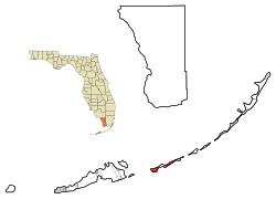
Monroe County Florida Incorporated and Unincorporated areas Marathon Highlighted.svg
Location in Monroe County and the U.S. state of Florida
Marathon.gif
U.S. Census Bureau map showing city limits
Coordinates: 24°43′35″N81°2′25″W / 24.72639°N 81.04028°W / 24.72639; -81.04028
Country Flag of the United States.svg  United States of America
State Flag of Florida.svg  Florida
County Seal of Monroe County, Florida.png Monroe
Incorporated 1999
Government
  Type Council-Manager
   Mayor Robyn Still
   Vice Mayor Luis Gonzalez
   Councilmembers Lynn Landry,
Kenny Matlock, and
Jeff Smith
   City Manager George Garrett
   City Clerk Diane Clavier
Area
[1]
  Total
9.28 sq mi (24.03 km2)
  Land8.45 sq mi (21.88 km2)
  Water0.83 sq mi (2.15 km2)
Elevation
3 ft (1 m)
Population
 (2020) [2]
  Total
9,689
  Density1,147.17/sq mi (442.91/km2)
Time zone UTC−5 (Eastern (EST))
  Summer (DST) UTC−4 (EDT)
ZIP Codes
33050−33052
Area code 305
FIPS code 12-43000 [3]
GNIS feature ID0286401 [4]
Website www.ci.marathon.fl.us

Marathon is a city in the middle of the Florida Keys, in Monroe County, Florida, United States. [5] As of the 2020 census, the city had a population of 9,689, [2] up from 8,297 in 2010.

Contents

History

A trailer park under construction in Marathon, 1973 TRAILER PARK UNDER CONSTRUCTION AT MARATHON IN THE CENTRAL FLORIDA KEYS. THIS IS ONE OF MANY SUCH PARKS SPRINGING UP... - NARA - 548762.jpg
A trailer park under construction in Marathon, 1973

Though the area has been settled for some time, Marathon is a relatively new city, incorporated in 1999.

The name Marathon dates back to the origin of the Florida East Coast Railroad. The name came from the railroad workers who were working night and day to complete the railway; due to the unrelenting pace and struggle to complete the project, workers complained that "this is getting to be a real marathon", and the word was later used to name the local railroad station. [6]

The Keys historian Dan Gallager in his book Florida's Great Ocean Railway credits New York playwright Witter Bynner for naming Marathon. According to Gallager, J.R. Parrott, then Florida East Coast Railway's President and General Manager, invited Brynner to the Keys to "plot stations for the railroad". When asked to generate a name for the station at Key Vaca, Brynner proposed "Marathon", inspired by the following passage from Byron: "The mountains look on Marathon—and Marathon looks on the sea."[ citation needed ]

Hurricane Irma

Marathon experienced significant damage from the September 10, 2017, U.S. landfall of Hurricane Irma. One of the earliest casualties of the storm was a man who died in a school shelter. [7] Marathon was one of the earliest spots in the Keys to receive transport of needed supplies to deal with the aftermath of Irma. The Air National Guard landed two C-130 transport planes every two hours beginning on the morning of September 11. [8]

Geography

Marathon occupies a series of keys (islands) near the middle of the Florida Keys. Via U.S. Route 1, it is 50 miles (80 km) northeast of Key West and 54 miles (87 km) southwest of Key Largo. To the south or southeast lies Hawk Channel, a popular passage for vessels traveling along the Keys. [9]

The city boundaries extend from the east end of the Seven Mile Bridge (Mile Marker 47) to the west end of Tom's Harbor Bridge (Mile Marker 61), excluding that portion of the area within the city limits of Key Colony Beach. [10] Among the islands within the city limits are Boot Key, Knight's Key, Hog Key, Vaca Key, Stirrup Key, Crawl Key, Little Crawl Key, East and West Sister's Island, Deer Key, Fat Deer Key (excluding the portion in Key Colony Beach), Long Point Key, and Grassy Key. The Marathon Publix and the United States Post Office for Marathon (zipcode 33050) are near the stop light on the Overseas Highway (US 1) for Sombrero Beach Road at Mile Marker (MM) 50 which is the major business district for Marathon and is about halfway between Key Largo and Key West. [11]

According to the United States Census Bureau, the city has a total area of 9.28 square miles (24.0 km2), of which 8.45 square miles (21.9 km2) are land and 0.83 square miles (2.15 km2), or 8.97%, are water. [1] Its city limits extend 1,200 feet (370 m) from land into the adjacent waters. [12]

Boot Key Harbor is a natural body of water between Boot Key and Key Vaca, entirely within the Marathon city limits. [13]

Climate

Marathon has a tropical savanna climate (Aw in the Köppen and Trewartha climate classifications). There is no record of snow/frost/freeze in Marathon. Like much of Florida and the Florida Keys, Marathon has two seasons; a hot and wet season from May through October, and a warm and dry season from November through April.

Climate data for Marathon, Florida (Florida Keys Marathon Airport), 1991–2020 normals, extremes 1950–present
MonthJanFebMarAprMayJunJulAugSepOctNovDecYear
Record high °F (°C)88
(31)
89
(32)
90
(32)
94
(34)
96
(36)
99
(37)
99
(37)
98
(37)
97
(36)
96
(36)
91
(33)
88
(31)
99
(37)
Mean maximum °F (°C)83.7
(28.7)
84.6
(29.2)
86.4
(30.2)
88.7
(31.5)
91.2
(32.9)
93.1
(33.9)
94.3
(34.6)
94.2
(34.6)
92.9
(33.8)
90.2
(32.3)
86.6
(30.3)
84.5
(29.2)
95.0
(35.0)
Mean daily maximum °F (°C)75.8
(24.3)
78.1
(25.6)
80.7
(27.1)
84.1
(28.9)
87.5
(30.8)
90.3
(32.4)
90.9
(32.7)
91.6
(33.1)
89.9
(32.2)
86.2
(30.1)
81.2
(27.3)
77.9
(25.5)
84.5
(29.2)
Daily mean °F (°C)70.0
(21.1)
72.3
(22.4)
74.6
(23.7)
78.3
(25.7)
81.7
(27.6)
84.4
(29.1)
85.2
(29.6)
85.6
(29.8)
84.2
(29.0)
81.0
(27.2)
76.0
(24.4)
72.7
(22.6)
78.8
(26.0)
Mean daily minimum °F (°C)64.2
(17.9)
66.4
(19.1)
68.5
(20.3)
72.5
(22.5)
75.8
(24.3)
78.5
(25.8)
79.4
(26.3)
79.7
(26.5)
78.4
(25.8)
75.8
(24.3)
70.8
(21.6)
67.5
(19.7)
73.1
(22.8)
Mean minimum °F (°C)50.4
(10.2)
53.3
(11.8)
57.1
(13.9)
63.8
(17.7)
69.8
(21.0)
72.6
(22.6)
73.8
(23.2)
73.2
(22.9)
73.1
(22.8)
68.8
(20.4)
60.6
(15.9)
55.1
(12.8)
47.7
(8.7)
Record low °F (°C)39
(4)
40
(4)
48
(9)
52
(11)
61
(16)
65
(18)
65
(18)
67
(19)
66
(19)
56
(13)
44
(7)
37
(3)
37
(3)
Average precipitation inches (mm)1.64
(42)
1.70
(43)
1.33
(34)
2.11
(54)
3.36
(85)
4.23
(107)
3.77
(96)
5.32
(135)
6.37
(162)
5.90
(150)
1.79
(45)
2.20
(56)
39.72
(1,009)
Average precipitation days (≥ 0.01 in)7.96.05.85.07.910.412.514.315.111.77.18.3112.0
Source: NOAA [14] [15]

Demographics

Historical population
CensusPop.Note
1970 4,397
1980 7,56872.1%
1990 8,85717.0%
2000 10,25515.8%
2010 8,297−19.1%
2020 9,68916.8%
U.S. Decennial Census [16]

2010 and 2020 census

Marathon racial composition
(Hispanics excluded from racial categories)
(NH = Non-Hispanic)
RacePop 2010 [17] Pop 2020 [18] % 2010% 2020
White (NH)5,5086,05866.39%62.52%
Black or African American (NH)3573654.30%3.77%
Native American or Alaska Native (NH)25160.30%0.17%
Asian (NH)90841.08%0.87%
Pacific Islander or Native Hawaiian (NH)260.02%0.06%
Some other race (NH)2260.02%0.27%
Two or more races/Multiracial (NH)892301.07%2.37%
Hispanic or Latino (any race)2,2242,90426.80%29.97%
Total8,2979,689

As of the 2020 United States census, there were 9,689 people, 3,879 households, and 2,151 families residing in the city. [19]

As of the 2010 United States census, there were 8,297 people, 3,755 households, and 2,247 families residing in the city. [20]

2000 census

As of the census [3] of 2000, there were 10,255 people, 4,597 households, and 2,735 families residing in the city. The population density was 1,186.1 inhabitants per square mile (458.0/km2). There were 6,791 housing units at an average density of 785.4 per square mile (303.2/km2). The racial makeup of the city was 91.09% White, 4.65% African American, 0.36% Native American, 0.48% Asian, 0.04% Pacific Islander, 2.00% from other races, and 1.38% from two or more races. Hispanic or Latino of any race were 20.43% of the population.

In 2000, there were 4,597 households, out of which 34.8% had children under the age of 18 living with them, 48.0% were married couples living together, 7.5% had a female householder with no husband present, and 20.5% were non-families. 29.2% of all households were made up of individuals, and 8.6% had someone living alone who was 65 years of age or older. The average household size was 2.19 and the average family size was 2.68.

In 2000, in the city, the population was spread out, with 17.3% under the age of 18, 6.1% from 18 to 24, 28.6% from 25 to 44, 32.0% from 45 to 64, and 16.0% who were 65 years of age or older. The median age was 44 years. For every 100 females, there were 110.6 males. For every 100 females age 18 and over, there were 111.7 males.

In 2000, the median income for a household in the city was $36,010, and the median income for a family was $46,361. Males had a median income of $27,057 versus $24,592 for females. The per capita income for the city was $22,894. About 9.4% of families and 14.2% of the population were below the poverty line, including 10.9% of those under age 18 and 13.5% of those age 65 or over.

As of 2000, English as a first language accounted for 78.10%, while Spanish as a mother tongue made up 20.95% of the population. [21]

Religion

Churches

Economy

Faro Blanco Lighthouse Faro Blanco Lighthouse.jpg
Faro Blanco Lighthouse

Marathon is a major sport fishing destination, with several charter fishing boats departing from local marinas every morning to both the Gulf of Mexico and the Atlantic Ocean. Bountiful reefs around Marathon make it a popular diving, snorkeling, spearfishing, and lobster tickling area. One of the last untouched tropical hardwood hammocks in the Keys is found at Crane Point Museum, just a few miles west of Florida Keys Marathon Airport. The vicinity of the airport is one of the most reliable sites in the United States to see the hard-to-find Antillean nighthawk. As in the rest of the Keys in summer, gray kingbirds are often seen on telephone wires along US 1 and black-whiskered vireos incessantly sing in the hammocks. Marathon also hosts burrowing owls.

The Fisherman's Hospital is in the west end of the city. It is one of just three hospitals in the Florida Keys. Marathon is home to another "hospital", The Turtle Hospital, one of a handful of facilities in the United States that rescue, rehabilitate, and release injured sea turtles.

Marathon derives much of its livelihood from the ocean and seafood is a staple at most restaurants.

Marathon has the tallest building in the Keys, Bonefish Tower at 143 feet (44 m) on Coco Plum, as well as Sombrero Country Club, the Keys' only country club. It was damaged by several recent hurricanes. With the redevelopment of the Faro Blanco property with a new Hyatt Place Hotel, restaurant and marina, and the redevelopment of the former Ramada Inn hotel into a new Hampton Inn and Suites hotel, Marathon is experiencing a social and economic rebirth.

Arts and culture

Library

A branch of the Monroe County Public Library System is located in Marathon. The current library was completed in 2021 and has several state of the art features relative to the previous library on the island. [22]

Education

Residents are zoned to schools in the Monroe County School District.

Schools

Transportation

Highways

Marathon is served by U.S. Highway 1, known locally as the Overseas Highway. The Overseas Highway extends westward, connecting Marathon with Key West. To the northeast, the Overseas Highway connects Marathon to Homestead and Miami.

Airport

Marathon is served by the Florida Keys Marathon Airport ( IATA : MTH, ICAO : KMTH).

Mass transit

Metrobus Route 301 (Dade-Monroe Express) carries riders back-and-forth from Marathon with a stop near MM 50 and the Publix store to a stop near Walmart in Florida City, with additional stops at Islamorada, Tavernier, and Key Largo. [23]

Key West Transit connects Marathon with Key West. [24]

Greyhound Lines buses run east and west from Marathon twice a day, stopping at the Marathon Airport.

Notable people

See also

Related Research Articles

<span class="mw-page-title-main">Monroe County, Florida</span> County in Florida, United States

Monroe County is the southernmost county of the state of Florida. As of the 2020 census, the population was 82,874. Its county seat is Key West. Monroe County includes the islands of the Florida Keys and comprises the Key West-Key Largo Micropolitan Statistical Area. Over 99.9% of the county's population lives on the Florida Keys. The mainland, which is part of the Everglades, comprises 87% of the county's land area and is virtually uninhabited with only 17 people recorded in the 2020 census.

<span class="mw-page-title-main">Monticello, Florida</span> City in Florida, United States

Monticello is the only city and the county seat of Jefferson County, Florida, United States. The city is named after Monticello, the estate of the county's namesake, Thomas Jefferson, on which the Jefferson County Courthouse was modeled. The population was 2,589 at the 2020 census. It is part of the Tallahassee, Florida Metropolitan Statistical Area.

<span class="mw-page-title-main">Sewall's Point, Florida</span> Town in the state of Florida, United States

Sewall's Point is a town located on the peninsula of the same name in Martin County, Florida, United States. The population was 1,991 at the 2020 census. Both the town and the peninsula are named for Capt. Henry Edwin Sewall. It is an eastern suburb of Stuart, which is the county seat of Martin County.

<span class="mw-page-title-main">Florida City, Florida</span> City in Florida

Florida City is a city in Miami-Dade County, Florida, United States. It is the southernmost municipality in the South Florida metropolitan area. Florida City is primarily a Miami suburb and a major agricultural area. As of the 2020 census, it had a population of 13,085, up from 11,245 in 2010.

<span class="mw-page-title-main">Homestead, Florida</span> City in Florida

Homestead is a city within Miami-Dade County in the U.S. state of Florida, between Biscayne National Park to the east and Everglades National Park to the west. Homestead is primarily a Miami suburb and a major agricultural area. It is a principal city of the Miami metropolitan area of South Florida, which was home to an estimated 6,012,331 people at the 2015 census. It is located approximately 26 miles (42 km) southwest of Miami, and 25 miles (40 km) northwest of Key Largo. The population was 80,737 as of the 2020 census.

<span class="mw-page-title-main">Islamorada, Florida</span> Village in Florida, United States

Islamorada is an incorporated village in Monroe County, Florida, United States. It is located directly between Miami and Key West on five islands—Tea Table Key, Lower Matecumbe Key, Upper Matecumbe Key, Windley Key and Plantation Key—in the Florida Keys. As of the 2020 census, the village had a population of 7,107, up from 6,119 in 2010.

<span class="mw-page-title-main">Big Pine Key, Florida</span> Census-designated place in Florida, United States

Big Pine Key is a census-designated place and unincorporated community in Monroe County, Florida, United States, on an island of the same name in the Florida Keys. As of the 2020 census, the town had a total population of 4,521.

<span class="mw-page-title-main">Duck Key, Florida</span> Census-designated place in Florida, United States

Duck Key is a census-designated place and unincorporated community in Monroe County, Florida, United States, on an island of the same name in the middle Florida Keys. The CDP also includes the neighboring island of Conch Key. As of the 2020 census, the CDP had a population of 727, up from 621 in 2010.

<span class="mw-page-title-main">Key Colony Beach, Florida</span> City in Florida, United States

Key Colony Beach is a municipality in the middle of the Florida Keys, Monroe County, Florida, United States. The population was 790 at the 2020 census.

<span class="mw-page-title-main">Key Largo, Florida</span> Census-designated place in Florida, United States

Key Largo is an unincorporated area and census-designated place in Monroe County, Florida, United States, located on the island of Key Largo in the upper Florida Keys. The population was 12,447 at the 2020 census, up from 10,433 in 2010. The name comes from the Spanish Cayo Largo, or "long key". It is both the first island and town of the Florida Keys to be reached from the Overseas Highway to Key West. It was also the location of one of the stations of the Overseas Railroad.

<span class="mw-page-title-main">Layton, Florida</span> City in Florida, United States

Layton is a city located on the island of Long Key in Monroe County, Florida, United States. The city is part of the Florida Keys. The population was 210 at the 2020 census.

<span class="mw-page-title-main">North Key Largo, Florida</span> Census-designated place in Florida, United States

North Key Largo is an unincorporated area and census-designated place (CDP) in Monroe County, Florida, United States. The population was 1,431 at the 2020 census, up from 1,244 in 2010. It includes two private clubs, the Ocean Reef Club and the Key Largo Anglers Club, and is reached from the mainland via the Card Sound Bridge.

<span class="mw-page-title-main">Tavernier, Florida</span> Census-designated place in Florida, United States

Tavernier is a census-designated place (CDP) and unincorporated community in Monroe County, Florida, United States on Key Largo, the largest island in the upper Florida Keys. Tavernier's population was 2,530 at the 2020 census, up from 2,136 in 2010.

<span class="mw-page-title-main">Largo, Florida</span> City in Florida, United States

Largo is the third largest city in Pinellas County, Florida, United States, as well as the fourth largest in the Tampa Bay area. As of the 2020 Census, the city had a population of 82,485, up from 77,648 in 2010.

<span class="mw-page-title-main">Madeira Beach, Florida</span> City in Florida, United States

Madeira Beach is a city in Pinellas County, Florida, United States, bordered on the west by the Gulf of Mexico, and on the east by St. Petersburg. As of the 2020 census, the population was 3,895. The entertainment district of John's Pass is located on the Intracoastal Waterway. The city is often referred to by locals as Mad Beach. It is named after the Portuguese island of Madeira.

<span class="mw-page-title-main">Auburndale, Florida</span> City in Florida, United States of America

Auburndale is a city in Polk County, Florida, United States. It is part of the Lakeland-Winter Haven, Florida Metropolitan Statistical Area. The population was 15,616 at the 2020 census.

<span class="mw-page-title-main">Florida Keys</span> Coral cay archipelago in Florida, United States

The Florida Keys are a coral cay archipelago off the southern coast of Florida, forming the southernmost part of the continental United States. They begin at the southeastern coast of the Florida peninsula, about 15 miles (24 km) south of Miami and extend in a gentle arc south-southwest and then westward to Key West, the westernmost of the inhabited islands, and on to the uninhabited Dry Tortugas. The islands lie along the Florida Straits, dividing the Atlantic Ocean to the east from the Gulf of Mexico to the northwest, and defining one edge of Florida Bay. The southern part of Key West is 93 miles (150 km) from Cuba. The Keys are located between about 24.3 and 25.5 degrees North latitude.

<span class="mw-page-title-main">Overseas Highway</span> Highway through the Florida Keys to Key West, Florida, USA

The Overseas Highway is a 113-mile (181.9 km) highway carrying U.S. Route 1 (US 1) through the Florida Keys to Key West. Large parts of it were built on the former right-of-way of the Overseas Railroad, the Key West Extension of the Florida East Coast Railway. Completed in 1912, the Overseas Railroad was heavily damaged and partially destroyed in the 1935 Labor Day hurricane. The Florida East Coast Railway was financially unable to rebuild the destroyed sections, so the roadbed and remaining bridges were sold to the state of Florida for $640,000.

<span class="mw-page-title-main">Monroe County School District (Florida)</span> School district in Florida, United States

Monroe County School District is a public school district serving the residents of Monroe County, Florida. The district's administrative offices are headquartered in Key West, Florida, United States, with school sites located throughout the Florida Keys from Key West to Key Largo. The district provides educational services for students enrolled in Pre-Kindergarten through 12th grade and educational opportunities for adult learners enrolled through adult education programs.

References

  1. 1 2 "2022 U.S. Gazetteer Files: Florida". United States Census Bureau. Retrieved January 18, 2023.
  2. 1 2 "P1. Race – Marathon city, Florida: 2020 DEC Redistricting Data (PL 94-171)". U.S. Census Bureau. Retrieved January 18, 2023.
  3. 1 2 "U.S. Census website". United States Census Bureau . Retrieved January 31, 2008.
  4. "US Board on Geographic Names". United States Geological Survey. October 25, 2007. Retrieved January 31, 2008.
  5. Zepke, T. (2017). Terrance Talk Travel: A Pocket Guide to the Florida Keys: Including The Everglades & Key West. Terrance Talks Travel. Safari Publishing. p. pt57. ISBN   978-1-942738-25-1 . Retrieved September 7, 2017.
  6. History of Marathon
  7. Goodhue, David. City of Marathon: 'Everything is underwater, I mean everything'. flkeysnews.com September 10, 2017. Accessed September 10, 2017.
  8. Goodhue, David. Massive airborne relief mission on the way to the Keys to help with 'humanitarian crisis'. flkeysnews.com September 10, 2017. Accessed September 10, 2017.
  9. Young, Stinemetz, Claiborne, Morgan (June 30, 2006). Cruising the Florida Keys (2nd ed.). Arcadia (published 2006). pp. 389–589. ISBN   9781455603206.{{cite book}}: CS1 maint: multiple names: authors list (link)
  10. "TIGERweb Decennial: Marathon city, Florida". Geography Division, U.S. Census Bureau. Retrieved January 18, 2023.
  11. Cox, Laura (August 16, 2010). "Sombrero Beach, Marathon". "Where the Locals Go…in the Florida Keys" website. Archived from the original on May 28, 2022. Retrieved May 28, 2022.
  12. City of Marathon Charter Archived 2006-10-04 at the Wayback Machine
  13. City of Marathon - Boot Key Harbor City Marina Archived 2007-05-03 at the Wayback Machine
  14. "NOWData – NOAA Online Weather Data". National Oceanic and Atmospheric Administration. Archived from the original on April 28, 2021. Retrieved May 9, 2021.
  15. "Summary of Monthly Normals 1991–2020". National Oceanic and Atmospheric Administration . Retrieved May 9, 2021.
  16. "Census of Population and Housing". Census.gov. Retrieved June 4, 2015.
  17. "P2 HISPANIC OR LATINO, AND NOT HISPANIC OR LATINO BY RACE - 2010: DEC Redistricting Data (PL 94-171) - Marathon city, Florida". United States Census Bureau .
  18. "P2 HISPANIC OR LATINO, AND NOT HISPANIC OR LATINO BY RACE - 2020: DEC Redistricting Data (PL 94-171) - Marathon city, Florida". United States Census Bureau .
  19. "S1101 HOUSEHOLDS AND FAMILIES - 2020: Marathon city, Florida". United States Census Bureau .
  20. "S1101 HOUSEHOLDS AND FAMILIES - 2010: Marathon city, Florida". United States Census Bureau .
  21. Modern Language Association Data Center Results of Marathon, Florida
  22. "Monroe County Public Library, Florida Keys" . Retrieved March 31, 2023.
  23. https://www.miamidade.gov/transit/library/routes/301.pdf [ bare URL PDF ]
  24. "Archived copy" (PDF). Archived from the original (PDF) on November 4, 2019. Retrieved November 4, 2019.{{cite web}}: CS1 maint: archived copy as title (link)