
Arcadia is a city and county seat of DeSoto County, Florida, United States. The population was 7,637 as of the 2010 census, with an estimated population of 7,722 in 2014. Arcadia's Historic District is listed on the National Register of Historic Places.

Key Colony Beach is a municipality in the middle of the Florida Keys, Monroe County, Florida, United States. The population was 797 at the 2010 census. As of 2018, the population estimated by the U.S. Census Bureau was 814.

Key West is an island in the Straits of Florida, within the U.S. state of Florida. Together with all or parts of the separate islands of Dredgers Key, Fleming Key, Sunset Key, and the northern part of Stock Island, it constitutes the City of Key West.
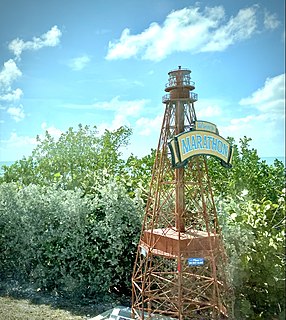
Marathon is a city spread over Knight's Key, Boot Key, Key Vaca, Fat Deer Key, Long Point Key, Crawl Key and Grassy Key islands in the middle of the Florida Keys, in Monroe County, Florida, United States. As of the 2010 census, the city had a total population of 8,297. As of 2019, the population estimated by the U.S. Census Bureau was 8,581.

The Florida Keys are a coral cay archipelago located off the southern coast of Florida, forming the southernmost part of the continental United States. They begin at the southeastern coast of the Florida peninsula, about 15 miles (24 km) south of Miami, and extend in a gentle arc south-southwest and then westward to Key West, the westernmost of the inhabited islands, and on to the uninhabited Dry Tortugas. The islands lie along the Florida Straits, dividing the Atlantic Ocean to the east from the Gulf of Mexico to the northwest, and defining one edge of Florida Bay. At the nearest point, the southern part of Key West is just 93 miles (150 km) from Cuba. The Florida Keys are between about 24.3 and 25.5 degrees North latitude.

Hurricane Donna, known in Puerto Rico as Hurricane San Lorenzo, was the strongest hurricane of the 1960 Atlantic hurricane season, and caused severe damage to the Lesser Antilles, the Greater Antilles, and the East Coast of the United States, especially Florida, in August–September. The fifth tropical cyclone, third hurricane, and first major hurricane of the season, Donna developed south of Cape Verde on August 29, spawned by a tropical wave to which 63 deaths from a plane crash in Senegal were attributed. The depression strengthened into Tropical Storm Donna by the following day. Donna moved west-northwestward at roughly 20 mph (32 km/h) and by September 1, it reached hurricane status. Over the next three days, Donna deepened significantly and reached maximum sustained winds of 130 mph (210 km/h) on September 4. Thereafter, it maintained intensity as it struck the Lesser Antilles later that day. On Sint Maarten, the storm left a quarter of the island's population homeless and killed seven people. An additional five deaths were reported in Anguilla, and there were seven other fatalities throughout the Virgin Islands. In Puerto Rico, severe flash flooding led to 107 fatalities, 85 of them in Humacao alone.

The Port River is part of a tidal estuary located north of the Adelaide city centre in the Australian state of South Australia. It has been used as a shipping channel since the beginning of European settlement of South Australia in 1836, when Colonel Light selected the site to use as a port. Before colonisation, the Port River region and the estuary area were known as Yerta Bulti by the Kaurna people, and used extensively as a source of food and plant materials to fashion artefacts used in daily life.

Boot Key is an island in the middle Florida Keys located adjacent to Key Vaca. Boot Key is within the city limits of Marathon, Florida, United States. The island is largely undeveloped. A draw bridge that once connected the island to Marathon is no longer in service and is now closed to pedestrian and vehicular traffic.
Key Vaca is an island in the middle Florida Keys, located entirely within the borders of the city of Marathon, Florida.

Hurricane Dennis caused flooding in North Carolina and the Mid-Atlantic states in early September 1999, which would later be compounded by Hurricane Floyd. The fifth tropical cyclone of the season, Dennis developed from a tropical wave to the north of Puerto Rico on August 24. Originally a tropical depression, the system moved west-northwestward and strengthened into a tropical storm despite unfavorable wind shear. The storm became a hurricane by August 26. After striking the Abaco Islands, conditions improved, allowing for Dennis to strengthen into a Category 2 on the Saffir–Simpson scale by August 28. Around this time, Dennis began to move parallel to the Southeastern United States. Early on August 30, the storm peaked with winds of 105 mph (165 km/h). By the following day, steering currents collapsed and the storm interacted with a cold front, causing Dennis to move erratically offshore North Carolina. Wind shear and cold air associated with the front weakened Dennis to a tropical storm on September 1 and removed some of its tropical characteristics. Eventually, warmer ocean temperatures caused some re-strengthening. By September 4, Dennis turned northwestward and made landfall in Cape Lookout, North Carolina, as a strong tropical storm. The storm slowly weakened inland, before transitioning into an extratropical cyclone over western New York on September 7.

The 1846 Havana hurricane was the most intense tropical cyclone in recorded history for 78 years and the first known Category 5-strength hurricane to strike Cuba. The first indications of the formation of a disturbance were first noted on 5 October in the Caribbean Sea, but little else was known until the storm approached Cuba on 10 October. There, it brought extreme winds and the lowest known atmospheric pressure of the time – 938 mbar (27.70 inHg) – a record which remained unbroken until the development of a later cyclone in 1924. It soon curved toward Florida, where it maintained its intensity, continuing to rapidly hasten northward along the East Coast of the United States to New England. It entered an extratropical transition while situated over New York on 13 October, producing intense Category 2-force winds and unusually little precipitation. Eventually, the gale dissipated over the Canadian Maritimes the following day as a markedly weaker storm.

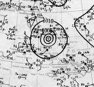
The 1944 Cuba–Florida hurricane was a large Category 4 tropical cyclone on the Saffir–Simpson hurricane wind scale that caused widespread damage across the western Caribbean Sea and Southeastern United States in October 1944. It inflicted over US$100 million in damage and caused at least 318 deaths, the majority of fatalities occurring in Cuba. One study suggested that an equivalent storm in 2018 would rank among the costliest U.S. hurricanes. The full extent of the storm's effects remains unclear due to a dearth of conclusive reports from rural areas of Cuba. The unprecedented availability of meteorological data during the hurricane marked a turning point in the United States Weather Bureau's ability to forecast tropical cyclones.
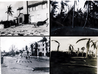
The 1929 Bahamas hurricane was a high-end Category 4 tropical cyclone whose intensity and slow forward speed led to catastrophic damage in the Bahamas in September 1929, particularly on Andros and New Providence islands. Its erratic path and a lack of nearby weather observations made the hurricane difficult to locate and forecast. The storm later made two landfalls in Florida, killing eleven but causing comparatively light damage. Moisture from the storm led to extensive flooding over the Southeastern United States, particularly along the Savannah River. Across its path from the Bahamas to the mouth of the Saint Lawrence River, the hurricane killed 155 people.

Dead Horse Bay is a small body of water off Barren Island, between the Gerritsen Inlet and Rockaway Inlet in the New York City borough of Brooklyn.
The Barker Inlet is a tidal inlet of the Gulf St Vincent in Adelaide, South Australia, named after Captain Collet Barker who first sighted it in 1831. It contains one of the southernmost mangrove forests in the world, a dolphin sanctuary, seagrass meadows and is an important fish and shellfish breeding ground. The inlet separates Torrens Island and Garden Island from the mainland to the east, and is characterised by a network of tidal creeks, artificially deepened channels, and wide mudflats. The extensive belt of mangroves are bordered by samphire saltmarsh flats and low-lying sand dunes.

The effects of Hurricane Wilma in Florida resulted in the storm becoming the third-costliest tropical cyclone in Florida history. Wilma developed in the Caribbean Sea just southwest of Jamaica on October 15 from a large area of disturbed weather. After reaching tropical storm intensity on October 17 and then hurricane status on October 18, the system explosively deepened, peaking as the strongest tropical cyclone ever recorded in the Atlantic basin. Wilma then slowly weakened while trekking to the northwest and fell to Category 4 intensity by the time it struck the Yucatán Peninsula on October 22. Thereafter, a strong cold front swept the storm northeastward into Florida on October 24, with landfall occurring near Cape Romano as a Category 3 hurricane with winds of 120 mph (190 km/h). Wilma continued rapidly northeastward into the Atlantic Ocean and became extratropical on October 26.
The 1947 Fort Lauderdale hurricane had widespread impacts in Florida. It produced significant flooding, damage to vegetation, and beach erosion in the Miami metropolitan area. After forming off West Africa on September 2, the storm moved on a parabolic path that brought it through The Bahamas as a Category 3 hurricane on September 16, eventually striking the city of Fort Lauderdale in South Florida as a powerful Category 4 hurricane on the following day. The hurricane later crossed the state, entered the Gulf of Mexico near Naples less than 24 hours later, and went on to strike Louisiana before dissipating on September 21.
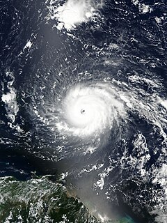
Hurricane Irma was an extremely powerful Cape Verde hurricane that caused widespread destruction across its path in September 2017. Irma was the first Category 5 hurricane to strike the Leeward Islands on record, followed by Maria two weeks later. At the time, it was considered as the most powerful hurricane on record in the open Atlantic region, outside of the Caribbean Sea and Gulf of Mexico until it was surpassed by Hurricane Dorian two years later. It was also the third strongest Atlantic hurricane at landfall ever recorded, just behind the 1935 Labor Day Hurricane and Hurricane Dorian.

Hurricane Irma was the most expensive storm in the history of the U.S. state of Florida. Irma developed from a tropical wave near the Cape Verde Islands on August 30, 2017. The storm quickly became a hurricane on August 31 and then a major hurricane shortly thereafter, but would oscillate in intensity over the next few days. By September 4, Irma resumed strengthening, and became a powerful Category 5 hurricane on the following day. The cyclone then struck Saint Maarten and the British Virgin Islands on September 6 and later crossed Little Inagua in the Bahamas on September 8. Irma briefly weakened to a Category 4 hurricane, but re-intensified into a Category 5 hurricane before making landfall in the Sabana-Camagüey Archipelago of Cuba. After falling to Category 3 status due to land interaction, the storm re-strengthened into a Category 4 hurricane in the Straits of Florida. Irma struck Florida twice on September 10 – the first as a Category 4 at Cudjoe Key and the second on Marco Island as a Category 3. The hurricane weakened significantly over Florida, and was reduced to a tropical storm, before exiting the state into Georgia on September 11.

