Marengo | |
---|---|
Motto: Home of Settlers Days | |
Coordinates: city_region:US-IL 42°15′03″N88°36′18″W / 42.25083°N 88.60500°W | |
Country | United States |
State | Illinois |
County | McHenry |
Township | Marengo, Seneca, Coral, Riley |
Founded | 1835 |
Government | |
• Mayor | John Koziol |
Area | |
• Total | 8.90 sq mi (23.06 km2) |
• Land | 8.90 sq mi (23.06 km2) |
• Water | 0.00 sq mi (0.00 km2) |
Elevation | 833 ft (254 m) |
Population (2020) | |
• Total | 7,568 |
• Density | 850.15/sq mi (328.25/km2) |
Time zone | UTC-6 (CST) |
• Summer (DST) | UTC-5 (CDT) |
ZIP Code | 60152 |
Area code(s) | 815/779 |
FIPS code | 17-46786 |
Wikimedia Commons | Marengo, Illinois |
Website | www.cityofmarengo.com |
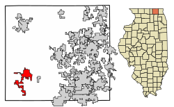
Marengo is a city in McHenry County, Illinois, United States on the Kishwaukee River. It lies approximately 60 miles west northwest of Chicago and approximately 30 miles east of Rockford. Per the 2020 census, the population was 7,568. [3]
Marengo is located at 42°15′3″N88°36′18″W / 42.25083°N 88.60500°W . [4]
The north edge of Marengo is bordered by the Kishwaukee River
According to the 2010 census, Marengo has a total area of 5.01 square miles (12.98 km2), all land. [5]
Climate data for Marengo, Illinois (1991–2020 normals, extremes 1893–2018) | |||||||||||||
---|---|---|---|---|---|---|---|---|---|---|---|---|---|
Month | Jan | Feb | Mar | Apr | May | Jun | Jul | Aug | Sep | Oct | Nov | Dec | Year |
Record high °F (°C) | 62 (17) | 73 (23) | 84 (29) | 94 (34) | 107 (42) | 107 (42) | 109 (43) | 107 (42) | 103 (39) | 90 (32) | 80 (27) | 67 (19) | 109 (43) |
Mean maximum °F (°C) | 47.6 (8.7) | 52.6 (11.4) | 68.9 (20.5) | 81.5 (27.5) | 87.2 (30.7) | 94.0 (34.4) | 95.3 (35.2) | 93.4 (34.1) | 89.3 (31.8) | 81.9 (27.7) | 67.1 (19.5) | 50.4 (10.2) | 97.1 (36.2) |
Mean daily maximum °F (°C) | 29.2 (−1.6) | 33.2 (0.7) | 44.9 (7.2) | 58.6 (14.8) | 70.2 (21.2) | 79.9 (26.6) | 83.5 (28.6) | 81.8 (27.7) | 75.4 (24.1) | 62.4 (16.9) | 46.9 (8.3) | 34.5 (1.4) | 58.4 (14.7) |
Daily mean °F (°C) | 20.9 (−6.2) | 24.5 (−4.2) | 35.4 (1.9) | 47.4 (8.6) | 58.7 (14.8) | 68.6 (20.3) | 72.6 (22.6) | 70.7 (21.5) | 63.6 (17.6) | 51.2 (10.7) | 38.0 (3.3) | 26.5 (−3.1) | 48.2 (9.0) |
Mean daily minimum °F (°C) | 12.7 (−10.7) | 15.8 (−9.0) | 25.9 (−3.4) | 36.2 (2.3) | 47.2 (8.4) | 57.2 (14.0) | 61.7 (16.5) | 59.6 (15.3) | 51.8 (11.0) | 39.9 (4.4) | 29.1 (−1.6) | 18.5 (−7.5) | 38.0 (3.3) |
Mean minimum °F (°C) | −11.3 (−24.1) | −6.1 (−21.2) | 7.5 (−13.6) | 20.6 (−6.3) | 32.1 (0.1) | 42.9 (6.1) | 49.4 (9.7) | 47.7 (8.7) | 35.4 (1.9) | 24.6 (−4.1) | 12.6 (−10.8) | −3.8 (−19.9) | −14.7 (−25.9) |
Record low °F (°C) | −29 (−34) | −27 (−33) | −16 (−27) | 6 (−14) | 21 (−6) | 29 (−2) | 39 (4) | 37 (3) | 24 (−4) | 8 (−13) | −17 (−27) | −26 (−32) | −29 (−34) |
Average precipitation inches (mm) | 1.67 (42) | 1.64 (42) | 2.08 (53) | 3.81 (97) | 4.57 (116) | 4.62 (117) | 4.05 (103) | 4.22 (107) | 3.68 (93) | 2.98 (76) | 2.35 (60) | 1.94 (49) | 37.61 (955) |
Average snowfall inches (cm) | 8.0 (20) | 9.1 (23) | 2.4 (6.1) | 0.4 (1.0) | 0.0 (0.0) | 0.0 (0.0) | 0.0 (0.0) | 0.0 (0.0) | 0.0 (0.0) | 0.0 (0.0) | 1.6 (4.1) | 9.3 (24) | 30.8 (78) |
Average precipitation days (≥ 0.01 in) | 7.2 | 5.8 | 7.9 | 10.5 | 11.7 | 9.8 | 9.0 | 9.0 | 7.2 | 8.0 | 7.4 | 7.4 | 100.9 |
Average snowy days (≥ 4.4) | 3.5 | 1.1 | 0.4 | 0.0 | 0.0 | 0.0 | 0.0 | 0.0 | 0.0 | 0.0 | 0.6 | 3.3 | 13.3 |
Source: NOAA (mean maxima/minima 1981–2010) [6] [7] |
Marengo was first named Pleasant Grove after a grove of trees near the town site. [8] The present name commemorates the Battle of Marengo. [8] A post office named Marengo was established in 1844. [9]
In the early morning of June 11, 2017, at around 4:50 A.M., a house in the northwest suburbs exploded. The gas explosion set four houses on fire and damaged 50 more, nearly 20 of which were deemed "unlivable." Despite the extensive damage, no fatalities or serious injuries occurred; only two people were reported to have suffered minor injuries. [10] [11]
Marengo is governed by the mayor, John Koziol, and a city council of eight aldermen.
Census | Pop. | Note | %± |
---|---|---|---|
1860 | 1,119 | — | |
1870 | 1,327 | 18.6% | |
1880 | 1,264 | −4.7% | |
1890 | 1,445 | 14.3% | |
1900 | 2,005 | 38.8% | |
1910 | 1,936 | −3.4% | |
1920 | 1,758 | −9.2% | |
1930 | 1,948 | 10.8% | |
1940 | 2,034 | 4.4% | |
1950 | 2,726 | 34.0% | |
1960 | 3,568 | 30.9% | |
1970 | 4,235 | 18.7% | |
1980 | 4,361 | 3.0% | |
1990 | 4,768 | 9.3% | |
2000 | 6,355 | 33.3% | |
2010 | 7,648 | 20.3% | |
2020 | 7,568 | −1.0% | |
U.S. Decennial Census [12] 2010 [13] 2020 [14] |
Race / Ethnicity (NH = Non-Hispanic) | Pop 2000 [15] | Pop 2010 [13] | Pop 2020 [14] | % 2000 | % 2010 | % 2020 |
---|---|---|---|---|---|---|
White alone (NH) | 5,441 | 6,305 | 5,758 | 85.62% | 82.44% | 76.08% |
Black or African American alone (NH) | 16 | 41 | 94 | 0.25% | 0.54% | 1.24% |
Native American or Alaska Native alone (NH) | 12 | 16 | 20 | 0.19% | 0.21% | 0.26% |
Asian alone (NH) | 18 | 37 | 51 | 0.28% | 0.48% | 0.67% |
Pacific Islander alone (NH) | 0 | 1 | 0 | 0.00% | 0.01% | 0.00% |
Other race alone (NH) | 0 | 7 | 16 | 0.00% | 0.09% | 0.21% |
Mixed race or Multiracial (NH) | 42 | 69 | 248 | 0.66% | 0.90% | 3.28% |
Hispanic or Latino (any race) | 826 | 1,172 | 1,381 | 13.00% | 15.32% | 18.25% |
Total | 6,355 | 7,648 | 7,568 | 100.00% | 100.00% | 100.00% |
As of the census [16] of 2000, there were 6,355 people, 2,387 households, and 1,694 families residing in the city. The population density was 1,598.5 inhabitants per square mile (617.2/km2). There were 2,475 housing units at an average density of 622.6 per square mile (240.4/km2). The racial makeup of the city was 92.07% White, 0.30% African American, 0.27% Native American, 0.28% Asian, 0.02% Pacific Islander, 5.54% of other races, and 1.53% of two or more races. Hispanic or Latino of any race were 13.00% of the population.
There were 2,387 households, out of which 38.6% had children under the age of 18 living with them, 55.9% were married couples living together, 10.7% had a female householder with no husband present, and 29.0% were non-families. 24.9% of all households were made up of individuals, and 9.8% had someone living alone who was 65 years of age or older. The average household size was 2.64 and the average family size was 3.17.
The population was spread out, with 29.3% under the age of 18, 8.6% from 18 to 24, 31.0% from 25 to 44, 19.2% from 45 to 64, and 12.0% who were 65 years of age or older. The median age was 34 years. For every 100 females, there were 96.3 males. For every 100 females age 18 and over, there were 94.3 males.
The median income for a household in the city was $50,214, and the median income for a family was $57,209. Males had a median income of $41,298 versus $26,317 for females. The per capita income for the city was $22,225. About 3.9% of families and 4.4% of the population were below the poverty line, including 5.4% of those under age 18 and 5.5% of those age 65 or over.
The Marengo-Union Times is the newspaper of record in Marengo, IL. It has a circulation of 6,300 and is mailed to every home and business in the greater Marengo and Union, Illinois area.
West Perrine is a census-designated place (CDP) in Miami-Dade County, Florida, United States. It is part of the Miami metropolitan area of South Florida. The population was 10,602 at the 2020 census, up from 9,460 in 2010.
Belvidere is a city in and the county seat of Boone County, Illinois. It is settled on the Kishwaukee River in far northern Illinois, United States. Known as the 'City of Murals', Belvidere is home to several public art installations throughout the North and South State Street historic districts, which are on the National Register of Historic Places. These historic districts are home to places like the Boone County Museum of History, The Funderburg Museum, several restaurants and bars, antique stores and Boutique stores. Popular festivities like Heritage Days are held yearly. The population was 25,339 as of the 2020 census. Belvidere is part of the Rockford, Illinois Metropolitan Statistical Area.
Burbank is a city in Cook County, Illinois, United States. The population was 29,439 at the 2020 census. It borders the southwest edge of the city of Chicago; the Chicago city limit – specifically that of the Ashburn neighborhood – is in common with Burbank's eastern city limit. Burbank shares a boundary with Oak Lawn to its south, Bridgeview to its west, and Bedford Park to its north; the city of Hometown is also adjacent to Burbank's southeast corner. Burbank is less than two miles south of Chicago Midway International Airport.
Burnham is a village in Cook County, Illinois, United States. The population was 4,046 at the 2020 census. The ZIP code is 60633.
Deer Park is a village in Lake and Cook Counties, Illinois. Per the 2020 census, the population was 3,681. The village is one of the few left in the Chicago area that enjoy a green belt which is bordered by two large natural areas providing outdoor recreation and open space. The village is home to popular shopping and dining destinations: Deer Park Town Center and the Town Center Promenade. The town is also home to the Vehe Farm, an Illinois Centennial Farm.
McCook is a village in Cook County, Illinois, United States, and is an industrial suburb of Chicago. As of the 2020 census, the village population was 249, which is the lowest population of all municipalities in the county.
Prospect Heights is a city in Cook County, Illinois, United States and is a suburb of Chicago. Per the 2020 census, the population was 16,058.
South Chicago Heights is a village and a south suburb in Cook County, Illinois, United States. The population was 4,026 at the 2020 census.
Thornton is a village in Cook County, Illinois, United States and a south suburb of Chicago. The population was 2,386 at the 2020 census. Thornton is home to the Thornton Quarry, one of the largest quarries in the world.
Malta is a village in DeKalb County, Illinois, United States. The population was 1,143 at the 2020 census.
Oakbrook Terrace is a city in DuPage County, Illinois, and is a suburb of Chicago. Per the 2020 census, the population was 2,751. It is the smallest town in DuPage County, in terms of area and population.
Hampshire is a village in Kane and McHenry counties, Illinois, United States. As of the 2020 census it had a population of 7,667.
Huntley is a village in McHenry and Kane counties, Illinois, United States. As of the 2021 census it had a population of 28,008. It is a part of the Chicago metropolitan area.
Pingree Grove is a village in Kane County, Illinois, United States. The population was 124 at the 2000 census. However, with rapid development in the following years, the 2010 census indicated 4,532 residents, and the 2020 census was 10,365.
Island Lake is a village in Lake and McHenry counties in the U.S. state of Illinois. Per the 2020 census, the population was 8,051. The village surrounds Island Lake, a lake which contains a small island.
Long Lake is an unincorporated community and census-designated place (CDP) in Lake County, Illinois, United States. Per the 2020 census, the population was 3,663.
Venice is a city in Madison County, Illinois, United States. The population was 1,498 at the 2020 census, down from 1,890 in 2010.
The Village of Lakewood is a village in McHenry County, Illinois, United States. It was incorporated as a village on July 10, 1933. Per the 2020 census, the population was 4,283. Although commonly referred to as Lakewood, the town's proper name is preceded by 'The Village of'.
Union is a village in McHenry County, Illinois, United States. The population was 551 at the 2020 census.
Merrill is a city in Plymouth County, Iowa, United States, along the Floyd River. The population was 717 at the time of the 2020 census.