Milesburg, Pennsylvania | |
---|---|
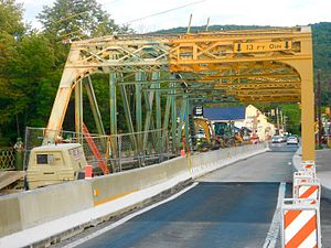
![]() Milesburg in December 2011 | |
![]() Location of Milesburg in Centre County, Pennsylvania | |
![]() Location of Centre County in Pennsylvania | |
Coordinates: 40°56′33″N77°47′21″W / 40.94250°N 77.78917°W | |
Country | United States |
State | Pennsylvania |
County | Centre |
Settled | 1793 |
Incorporated (borough) | 1843 |
Government | |
• Mayor | Clair Martin |
Area | |
• Total | 0.44 sq mi (1.13 km2) |
• Land | 0.44 sq mi (1.13 km2) |
• Water | 0.00 sq mi (0.00 km2) |
Elevation | 692 ft (211 m) |
Population | |
• Total | 1,093 |
• Density | 2,501.14/sq mi (965.97/km2) |
Time zone | Eastern (EST) |
• Summer (DST) | EDT |
Zip Code | 16853 |
Area code | 814 |
FIPS code | 42-49368 |
Milesburg is a borough in Centre County, Pennsylvania. It is part of the State College, Pennsylvania metropolitan statistical area. The population was 1,093 at the 2020 census.
Milesburg and nearby Miles Township were named after Samuel Miles, [3] who co-owned the Centre Furnace Iron Works, along with Colonel John Patton and John Dunlop.
Milesburg is located near the site of a former Lenape Indian settlement known as Bald Eagle's Nest.
Iddings-Baldridge House in Milesburg was added to the National Register of Historic Places in 1977. [4]
Milesburg is located at 40°56′33″N77°47′21″W / 40.94250°N 77.78917°W (40.942533, -77.789207). [5]
According to the U.S. Census Bureau, the borough has a total area of 0.4 square miles (1.0 km2), all land.
Census | Pop. | Note | %± |
---|---|---|---|
1850 | 478 | — | |
1860 | 591 | 23.6% | |
1870 | 600 | 1.5% | |
1880 | 643 | 7.2% | |
1890 | 714 | 11.0% | |
1900 | 594 | −16.8% | |
1910 | 531 | −10.6% | |
1920 | 545 | 2.6% | |
1930 | 644 | 18.2% | |
1940 | 681 | 5.7% | |
1950 | 733 | 7.6% | |
1960 | 729 | −0.5% | |
1970 | 1,196 | 64.1% | |
1980 | 1,309 | 9.4% | |
1990 | 1,144 | −12.6% | |
2000 | 1,187 | 3.8% | |
2010 | 1,123 | −5.4% | |
2020 | 1,093 | −2.7% | |
Sources: [6] [7] [8] [2] |
At the 2010 census there were 1,123 people, 459 households, and 305 families residing in the borough. The population density was 2,503.4 inhabitants per square mile (966.6/km2). There were 489 housing units at an average density of 1,090.1 per square mile (420.9/km2). The racial makeup of the borough was 98.7% White, 0.4% Black or African American, 0.1% Native American, 0.4% Asian, 0.2% other, and 0.2% from other races. Hispanic or Latino of any race were 0.3%. [7]
There were 459 households, 29.8% had children under the age of 18 living with them, 47.3% were married couples living together, 6.2% had a male householder with no wife present, 12.9% had a female householder with no husband present, and 33.6% were non-families. 26.6% of households were made up of individuals, and 8.5% were one person aged 65 or older. The average household size was 2.45 and the average family size was 2.77.
In the borough, the population was spread out, with 19.1% under the age of 18, 8.8% from 18 to 24, 25.3% from 25 to 44, 29.3% from 45 to 64, and 17.5% 65 or older. The median age was 42 years. For every 100 females there were 89.1 males. For every 100 females age 18 and over, there were 87.8 males.
The median household income was $45,588 and the median family income was $51,597. The per capita income for the borough was $19,310. About 5.0% of families and 7.2% of the population were below the poverty line, including 1.7% of those under age 18 and 3.4% of those age 65 or over.
Emsworth is a borough in Allegheny County, Pennsylvania, United States, along the Ohio River. The population was 2,525 at the 2020 census.
Verona is a borough in Allegheny County, Pennsylvania, United States. It is 13 miles (21 km) northeast of downtown Pittsburgh, along the left bank of the Allegheny River. As of the 2020 census, the borough had a population of 2,492.
Boggs Township is a township in Centre County, Pennsylvania, United States. It is part of the State College, Pennsylvania Metropolitan Statistical Area. It is located north of Bellefonte at approximately 40°54′48″N77°45′53″W. As of the 2010 census, the township population was 2,985.
Centre Hall is a borough in Centre County, Pennsylvania, United States. It is located in Penns Valley and is part of the State College, Pennsylvania Metropolitan Statistical Area. The population was 1,265 at the 2010 census, which is a 17.2% increase from the 2000 census.
Julian is an unincorporated community and census-designated place (CDP) that is located in Centre County, Pennsylvania, United States. It is part of the State College, Pennsylvania Metropolitan Statistical Area. The population was 152 at the 2010 census. Most locals pronounce the name "Joo-lee-ānn".
Millheim is a borough in Centre County, Pennsylvania, United States. It is part of the State College, Pennsylvania Metropolitan Statistical Area. The population was 904 at the 2010 census. The Millheim Historic District, which includes 176 contributing buildings, was listed on the National Register of Historic Places in 1986.
Union Township is a township that is located in Centre County, Pennsylvania, United States. It is part of the State College, Pennsylvania Metropolitan Statistical Area.
Chester Hill is a borough in Clearfield County, Pennsylvania, United States. The population was 821 at the 2020 census.
Wallaceton is a borough in Clearfield County, Pennsylvania, United States. The population was 297 at the 2020 census.
Beech Creek is a borough in Clinton County, Pennsylvania, United States. The population was 701 at the 2010 census. It is the setting for Fun Home, a 2006 graphic memoir by Alison Bechdel, who grew up there. Brittani Kline, winner of America's Next Top Model, Cycle 16, was born there.
Newburg is a borough in Cumberland County, Pennsylvania, United States. The population was 336 at the 2010 census. It is part of the Harrisburg–Carlisle metropolitan statistical area.
Brownsville Township is a township in Fayette County, Pennsylvania, United States. The population was 536 at the 2020 census, a decline from the figure of 683 tabulated in 2010. It is served by the Brownsville School District.
Duncannon is a borough in Perry County, Pennsylvania, United States. The population was 1,473 at the 2020 census. It is part of the Harrisburg–Carlisle Metropolitan Statistical Area. The center of population of Pennsylvania is located in Duncannon. Lightning Guider Sleds were manufactured in Duncannon from 1904 until 1988. The Appalachian Trail makes its way through the town, going on various streets, and runs mainly along North High Street. It comes off the mountain at 40.3813, -77.0292 lat/long, onto Inn Road.
Finleyville is a borough in Washington County, Pennsylvania, United States, named for John Finley. The population was 375 at the 2020 census. It was built at the junction of Brownsville Road and the 'Washington Road' from Cox's Fort to Catfish Camp, now Washington, Pennsylvania. It was originally known as "Rowgalley" until after a large contingent of Scots-Irish came to town including a number of "Finleys." It is in the Peters Creek watershed.
New Eagle is a borough in Washington County, Pennsylvania, United States and is part of the Pittsburgh Metro Area. The population was 2,047 at the 2020 census.
Twilight is a borough in Washington County, Pennsylvania, United States. The population was 216 at the 2020 census.
Penn is a borough in Westmoreland County, Pennsylvania, United States. The population was 475 at the time of the 2010 census.
West Leechburg is a borough in Westmoreland County, Pennsylvania, United States, along the Kiskiminetas River. The population was 1,294 at the 2010 census.
Cross Roads is a borough in York County, Pennsylvania, United States. The population was 524 at the 2020 census. It is part of the York–Hanover metropolitan area. The crossroads in the borough is where Church Road intersects Cross Roads Avenue and is joined by Century Farms Road.
Franklintown is a borough in York County, Pennsylvania, United States. The population was 518 at the 2020 census. It is part of the York–Hanover metropolitan area.