
Arietta is a town in Hamilton County, New York, United States. The population was 292 at the 2020 census. The town was named after the mother of one of the first settlers, Rensselaer Van Rennslaer.

Ohio is a town in Herkimer County, New York, United States. The population was 1,002 at the 2010 census. The town is named after the state of Ohio. The town is in the northern part of the county and northeast of Utica. Part of Ohio is within the Adirondack Park.

The Black Rock Desert is a semi-arid region of lava beds and playa, or alkali flats, situated in the Black Rock Desert–High Rock Canyon Emigrant Trails National Conservation Area, a silt playa 100 miles (160 km) north of Reno, Nevada, that encompasses more than 300,000 acres (120,000 ha) of land and contains more than 120 miles (200 km) of historic trails. It is in the northern Nevada section of the Great Basin with a lakebed that is a dry remnant of Pleistocene Lake Lahontan.

The Cargo Muchacho Mountains are located in the southeast Colorado Desert in the Lower Colorado River Valley, in Imperial County, California in the United States. Much of the range's geology was described by the geologist John T. Dillon.

The geography of Texas is diverse and large. Occupying about 7% of the total water and land area of the U.S., it is the second largest state after Alaska, and is the southernmost part of the Great Plains, which end in the south against the folded Sierra Madre Oriental of Mexico. Texas is in the South Central United States of America, and is considered to form part of the U.S. South and also part of the U.S. Southwest.

Woody's Knob, at an elevation of 4,170 feet, is a summit or "knob" in the Blue Ridge Mountains and one of the highest points in the unincorporated village of Little Switzerland and in Mitchell County, North Carolina.

The Cerbat Mountains is a mountain range in Mohave County in northwest Arizona immediately north of Kingman. The Cerbat Mountains and the White Hills (Arizona) adjacent north, are the dividing ranges between the Detrital Valley west, and the Hualapai Valley east.

The Eldorado Mountains, also called the El Dorado Mountains, are a north-south trending mountain range in southeast Nevada bordering west of the south-flowing Colorado River; the endorheic Eldorado Valley borders the range to the west, and the range is also on the western border of the Colorado River's Black Canyon of the Colorado, and El Dorado Canyon on the river. The range is 50 miles (80 km) southeast of Las Vegas, Nevada; and the Eldorado Mountains connect with the Highland and Newberry mountains.
The Agua Dulce Mountains are a mountain range in the north-central Sonoran Desert of southwestern Arizona. The range is located in the extreme southwestern portion of Pima County, Arizona, immediately north of the international boundary with Mexico and about 30 mi (48 km) southwest of Ajo, Arizona. The range has three main sections that total about 15 miles in length and about nine miles in width. The range is located entirely within the Cabeza Prieta National Wildlife Refuge. The highpoint of the range is 2,852 feet (869 m) above sea level and is located at 32°01'32"N, 113°08'44"W. The summit is unnamed, but is marked on U.S. Geological Survey (USGS) maps for the "Quitovaquita" benchmark that was placed on the summit in 1920. The original surveyed height was 2,850 feet above sea level, but recent datum adjustments calculate the summit to be two feet higher.
Summerlee is an unincorporated community and coal town in Fayette County, West Virginia, United States. Summerlee is 2 miles (3.2 km) north-northwest of Oak Hill. The Summerlee Mine was located here and was owned by the New River Coal Company.

The Buckskin Mountains is a mountain range in La Paz County, Arizona, United States. The range lies just east of the north–south Colorado River, and borders south of the east–west, west-flowing Bill Williams River.

The Black Hills of Yavapai County are a large mountain range of central Arizona in southeast Yavapai County. It is bordered by the Verde Valley to the east. The northwest section of the range is bisected from the southeast section by Interstate 17, which is the main route connecting Phoenix to Sedona, Oak Creek Canyon, and Flagstaff. This bisection point is the approximate center of the mostly northwest by southeast trending range. The northwest section contains a steep escarpment on the northeast with the Verde Valley, the escarpment being the location of the fault-block that created the historic mining district at Jerome. The United Verde Mine was one of the largest copper mines in the United States, producing large quantities of copper, gold, silver and zinc.

The Vulture Mountains is a 29-mile (47 km) long, arid, low-elevation mountain range located in northwest Maricopa County, Arizona, United States. It is in the north perimeter region of the Sonoran Desert. The Arizona transition zone mountain ranges lie north and northeast, just north of Wickenburg, Arizona. The Yarnell Hill, about 14 miles (23 km) north of Wickenburg, rising into the Weaver Mountains to Yarnell, marks the dramatic elevation rise from the desert. It is also a viewpoint southwest and southeast of the desert regions, including the Vulture Mountains.
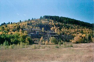
Bismuth is a ghost town in the Black Hills of Custer County, South Dakota, United States.
Trojan, also known as Portland, is a ghost town in the Black Hills of Lawrence County, South Dakota. It was established by and named after the Trojan Mining Company.
Spokane is a ghost town located in Custer County, South Dakota, United States. Founded in 1890, it was a mining camp in the Black Hills until its abandonment in the mid-20th century.
Novak, also known as Cindell Spur, is a ghost town in Lawrence County, South Dakota, United States. It was an early mining camp.

Castle Mountains National Monument is a U.S. National Monument located in the eastern Mojave Desert and northeastern San Bernardino County, in the state of California.

Rum Hill is a mountain located in Central New York Region of New York northwest of the Hamlet of Pierstown. Red House Hill is located southeast, Metcalf Hill is located south, Allen Lake and Mohegan Hill are located north-northwest and Otsego Lake is located east of Rum Hill.
Woodchuck Hill is a mountain in Schoharie County, New York. It is located northwest of South Gilboa. Mine Hill is located south-southeast and Mount Jefferson is located west-southwest of Woodchuck Hill.

