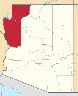
Moccasin, Arizona | |
---|---|
Coordinates: 36°54′34″N112°45′32″W / 36.90944°N 112.75889°W | |
Country | United States |
State | Arizona |
County | Mohave |
Area | |
• Total | 0.77 sq mi (1.98 km2) |
• Land | 0.77 sq mi (1.98 km2) |
• Water | 0.00 sq mi (0.00 km2) |
Elevation | 5,092 ft (1,552 m) |
Population | |
• Total | 53 |
• Density | 69.19/sq mi (26.72/km2) |
Time zone | UTC-7 (Mountain (MST)) |
ZIP Code | 86022 (Fredonia) |
Area code | 928 |
GNIS feature ID | 8145 |
FIPS code | 04-47190 |
Moccasin is an unincorporated community and census-designated place in Mohave County, Arizona, United States. It is within the Kaibab Indian Reservation, and its population was 53 as of the 2020 census, [2] down from 89 at the 2010 census. It is bordered to the south by the CDP of Kaibab.
It is believed a moccasin-shaped shoe-print by a nearby spring caused the name to be selected. [3] Sometime in the late 1800s.
Census | Pop. | Note | %± |
---|---|---|---|
2010 | 89 | — | |
2020 | 53 | −40.4% | |
U.S. Decennial Census [4] |
The CDP is in the Fredonia-Moccasin Unified School District. [5]
Mohave County is a county in the northwestern corner of the U.S. state of Arizona. As of the 2020 census, its population was 213,267. The county seat is Kingman, and the largest city is Lake Havasu City. It is the fifth largest county in the United States.
Kaibab is an unincorporated community and census-designated place (CDP) in Mohave County, Arizona, United States. It is within the Kaibab Indian Reservation. The population of the CDP was 140 at the 2020 census.
Arizona Village is a census-designated place (CDP) on the Fort Mojave Indian Reservation in Mohave County, Arizona, United States. The population was 1,057 at the 2020 census, up from 946 in 2010 and 351 in 2000.
Mesquite Creek is an unincorporated community and census-designated place (CDP) in Mohave County, Arizona, United States. The population was 403 at the 2020 census.
Mohave Valley is an unincorporated community and census-designated place (CDP) in Mohave County, Arizona, United States. The population was 2,693 at the 2020 census. It is geographically connected to Needles, California, Fort Mohave and Bullhead City.
Willow Valley is an unincorporated community and census-designated place (CDP) in Mohave County, Arizona, United States. The population was 1,059 as of the 2020 census.
Littlefield is an unincorporated community and census-designated place in Mohave County, Arizona, United States, that is located in the Arizona Strip region. As of the 2020 census, its population was 256, a decline from the figure of 308 tabulated in 2010. It lies just south of Interstate 15, next to the Virgin River, approximately 10 miles (16 km) northeast of Mesquite, Nevada. Littlefield is located in the 86432 ZIP Code.
Fredonia-Moccasin Unified School District is a school district headquartered in Fredonia, Arizona, United States. It was founded via the merger of Fredonia Elementary School District, Fredonia High School District, Moccasin School District, and Cane Beds School District in May 1974 as the state's first, and to date only ever, school district to cross county lines.
Valentine is an unincorporated community and census-designated place (CDP) in Mohave County, Arizona, United States. As of the 2020 census it had a population of 39. Valentine is located on Arizona State Route 66 32 miles (51 km) northeast of Kingman. The majority of Valentine is located in a geographically isolated exclave of the Hualapai Reservation and the rest of the community is located in unincorporated Mohave County.
Cane Beds is an unincorporated community and census-designated place (CDP) in Mohave County, Arizona, United States. It lies 4 miles (6 km) south of the border with Utah in the Arizona Strip, and is supported by services in Utah as well as some in Nevada.
Crozier is an unincorporated community and census-designated place (CDP) in Mohave County, Arizona, United States. The population was 21 at the 2020 census.
Crystal Beach is an unincorporated community in Mohave County, Arizona, United States. The population was 250 at the 2020 census. For statistical purposes, the United States Census Bureau has defined Crystal Beach as a census-designated place (CDP).
Golden Shores is a census-designated place (CDP) in Mohave County, Arizona, United States. The population was 1,927 at the 2020 census. Residents are part of the 86436 ZIP code area, with a mailing address of Topock.
Katherine is an unincorporated community and census-designated place (CDP) in Mohave County, Arizona, United States. The population was 76 at the 2020 census, down from 103 at the 2010 census.
Lazy Y U is an unincorporated community and census-designated place (CDP) in Mohave County, Arizona, United States. The population was 474 at the 2020 census, up from 428 at the 2010 census.
McConnico is an unincorporated community and census-designated place (CDP) in Mohave County, Arizona, United States. The population was 63 at the 2020 census.
So-Hi is an unincorporated community and census-designated place in Mohave County, in the U.S. state of Arizona. The population was 428 at the 2020 census, down from 477 in 2010.
Valle Vista is an unincorporated community and census-designated place (CDP) in Mohave County, in the U.S. state of Arizona. The population was 1,802 at the 2020 census.
Walnut Creek is an unincorporated community and census-designated place (CDP) in Mohave County, in the U.S. state of Arizona. The population was 571 at the 2020 census.
Kaibab Estates West is an unincorporated community and census-designated place (CDP) in Coconino County, Arizona, United States. It is bordered to the south by Yavapai County. It was first listed as a CDP prior to the 2020 census.