
Alappuzha district, is one of the 14 districts in the Indian state of Kerala. It was formed as Alleppey district on 17 August 1957, the name of the district being changed to Alappuzha in 1990. Alappuzha is the smallest district of Kerala. Alleppey town, the district headquarters, was renamed Alappuzha in 2012.

Pathanamthitta District, is one of the 14 districts in the Indian state of Kerala. The district headquarters is in the town of Pathanamthitta. There are four municipalities in Pathanamthitta: Adoor, Pandalam, Pathanamthitta and Thiruvalla.

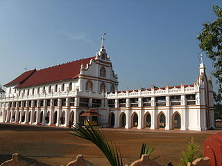
Niranam is a village in Thiruvalla, Kerala, India. It was a port in ancient Kerala, on the confluence of the Manimala and Pamba River. It is almost 7 km from Tiruvalla SCS Junction in Pathanamthitta District of Kerala, lies to the western part of Tiruvalla, identified as Upper Kuttanad region. It Is Part Of Thiruvalla Sub-District.Also Comes Under Thiruvalla Constituency.It is identified with Nelcynda in Periplus of the Erythraean Sea.

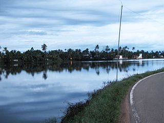
Kuttanad is a river delta landscape region in the state of Kerala, India, known for its vast paddy fields and geographical peculiarities. It is in the Districts of Alappuzha, Kottayam and Pathanamthitta. The region has the lowest altitude in India, and is one of the few places in the world where farming is carried on around 1.2 to 3.0 metres below sea level,, using rice paddies largely located on reclaimed land amid the delta. Kuttanad is historically important in the ancient history of South India and is the major rice producer in the state. Farmers of Kuttanad are famous for Biosaline Farming. The United Nations Food and Agriculture Organization (FAO) has declared the Kuttanad Farming System as a Globally Important Agricultural Heritage System (GIAHS) in 2013.

Maramon is a small village on the Pampa River in Thiruvalla taluk & Thiruvalla Revenue Division of Pathanamthitta district in the state of Kerala, India. The nearest railway station is at chengannur (13 km) & Thiruvalla Maramon is about 16 km from the Thiruvalla. The T.K.Road connects the town to other major towns.

Achankovil is a 128 km (80 mi) long west flowing river in Kerala, India. It flows through the districts of Kollam, Pathanamthitta and Alappuzha. The river drains vast tract of fertile plains of Upper Kuttanad in the Alappuzha and Pathanamthitta districts. It also sustains numerous urban settlements along its course such as Konni, Pathanamthitta, Pandalam and Mavelikkara.

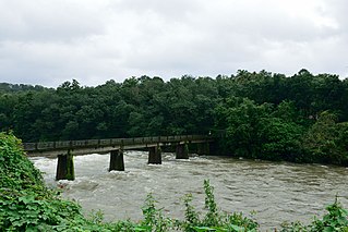
The Pamba River is the longest river in the Indian state of Kerala after Periyar and Bharathappuzha, and the longest river in the erstwhile former princely state of Travancore. The Sabarimala Temple, dedicated to Lord Ayyappa, is located on the banks of the river Pamba.
Edathua is a small village in Kuttanad, Alappuzha district, Kerala, India. It is located 12 km from Thiruvalla city center, National Highway 183 and the Thiruvalla railway station.

Chengannur is a municipality in the Alappuzha district of Kerala, India. It is located 43 km (26.7 mi) south east of the district headquarters in Alappuzha and about 98 km (60.9 mi) north of the state capital Thiruvananthapuram. As per the 2011 Indian census, Chengannur has a population of 23,466 people, and a population density of 1,607/km2 (4,160/sq mi).

Pathanamthitta, is a municipality situated in the Southern Kerala, India, spread over an area of 23.50 km2. It is the administrative capital of Pathanamthitta district. The town has a population of 37,538. The Hindu pilgrim centre Sabarimala is situated in the Pathanamthitta district; as the main transport hub to Sabarimala, the town is known as the 'Pilgrim Capital of Kerala'. Pathanamthitta District, the thirteenth revenue district of the State of Kerala, was formed with effect from 1 November 1982, with headquarters at Pathanamthitta. Forest covers more than half of the total area of the District. Pathanamthitta District ranks the 7th in area in the State. The district has its borders with Allepey, Kottayam, Kollam and Idukki districts of Kerala and Tamil Nadu. Nearest town is Thiruvalla, located at a distance of 30 km. Thiruvalla railway station is 30 km via Thiruvalla-Kumbazha highway.
Karuvatta is a village in Alappuzha District of Kerala region of India. It lies in between Haripad and Thottappally in Alappuzha, on National Highway 66. Karuvatta has a railway station, and the nearest airports are Trivandrum International Airport and Cochin International Airport.
Thalavady is an Upper Kuttanadu village and Panchayat located in Kuttanadu Taluk, Alappuzha district, Kerala, India. The village was ruled by King of Chembakassery Kingdom. Its geography is dominated by its vast lush green paddy field, unique to Kuttanad villages, bordered by a network of canals running between the fields and the Pampa River that flows through the village. Thalavady panchayat office is located in Trikkayil.
Mulakuzha or മുളക്കുഴ is a village in Alappuzha district in the state of Kerala, India. Mulakuzha is located in Chengannur tehsil, and residents are mostly artisans and farmers.
Muttar is a village in upper Kuttanad, Alappuzha district of Kerala, India. It is located 10 km west of Thiruvalla on the Kidangara Neerattupuram road, surrounded by Thalavady, Neerettupuram, Kunnamkary, Chathamkary & Mithrakary.

Kadapra is a village in the Thiruvalla subdistrict of Pathanamthitta district, Kerala state, India. It shares an intradistrict river border with Nedumpuram village separated along the Manimala river towards its north and an interpenetrating intradistrict land border with Niranam village towards its west.
Peringara is a village and in the Peringara gram panchayat in Pathanamthitta district, Kerala. Peringara is located 3.9 km from Thiruvalla. The gram panchayat includes the wards of Mepral, Idinjillam, Perumthuruthy, and Chathenkary.
Kottathur is a prominent ward in Ayroor Panchayat situated on the eastern part of Ayroor, in Pathanamthitta district of Kerala state, India.
Keezhvaipur is a village in the Mallappally Taluk which is one of five Taluks that makes up the Pathanamthitta district, in Kerala State, India.It Is Part Of Thiruvalla Constituency.Keezhuvaipur lies in the bank of river Manimala and is famous for its traditions, cultures, and customs. The town is located on the Kottayam-Punalur State Highway. Keezhuvaipur is 3 km away from Mallappally, 11 km from Kozhencherry and 13 km from Tiruvalla.
Manimala River, or Manimalayar, is a 92km long river which flows through South and Central Kerala. The river used to be wrongly considered as a tributary of Pamba River before satellite maps became popular, but this was proved incorrect. Manimala does not flow into the Pamba, instead a distributary of the Pamba river flows into the Manimala river at Kallunkal, later branches out again from Manimala at Nedumpuram and flows through Niranam, Thalavady, Edathua, Changankary, Champakulam, Nedumudy, Chennamkary, and finally Kainakary and then empties into the Vembanad lake. This branch again links with the Manimala River at Chennankary in a short, but broad connection known as Munnattumukham.

Chathenkary is a village in the Peringara gram panchayat in the Thiruvalla taluk of the Pathanamthitta district, Kerala.


