"},"elevation_ft":{"wt":"1224"},"coordinates":{"wt":"{{coord|40|57|53|N|80|33|35|W|region:US_type:city|display=inline,title}}"},"postal_code_type":{"wt":"[[ZIP code]]"},"postal_code":{"wt":"44442"},"area_code":{"wt":"[[Area codes 234 and 330|234/330]]"},"blank_name":{"wt":"[[Federal Information Processing Standard|FIPS code]]"},"blank_info":{"wt":"39-55118{{cite web|url=https://www.census.gov|publisher=[[United States Census Bureau]]|accessdate=January 31, 2008|title=U.S. Census website}}"},"blank1_name":{"wt":"[[Geographic Names Information System|GNIS]] feature ID"},"blank1_info":{"wt":"1086567{{GNIS|1086567}}"},"website":{"wt":"{{URL|http://villageofnewmiddletown.com/}}"},"footnotes":{"wt":""}},"i":0}}]}" id="mwBQ">Village in Ohio, United States
New Middletown, Ohio | |
---|---|
New Middletown Municipal Building | |
![]() Location of New Middletown in Mahoning County, Ohio. | |
Coordinates: 40°57′53″N80°33′35″W / 40.96472°N 80.55972°W | |
Country | United States |
State | Ohio |
County | Mahoning |
Township | Springfield |
Area | |
• Total | 0.88 sq mi (2.27 km2) |
• Land | 0.87 sq mi (2.26 km2) |
• Water | 0.00 sq mi (0.00 km2) |
Elevation | 1,224 ft (373 m) |
Population (2020) | |
• Total | 1,507 |
• Density | 1,726.23/sq mi (666.39/km2) |
Time zone | UTC-5 (Eastern (EST)) |
• Summer (DST) | UTC-4 (EDT) |
ZIP code | 44442 |
Area code(s) | 234/330 |
FIPS code | 39-55118 [3] |
GNIS feature ID | 1086567 [2] |
Website | villageofnewmiddletown |
New Middletown is a village in southeastern Mahoning County, Ohio, United States. The population was 1,507 at the 2020 census. [4] It is part of the Youngstown–Warren metropolitan area.
In 1825, New Middletown was founded by Samuel Moore [5] and became an incorporated town in 1972. [6] The village was most likely named after Middletown, Dauphin County, Pennsylvania, the former home of a share of the first settlers. [5]
According to the United States Census Bureau, the village has a total area of 0.87 square miles (2.25 km2), all land. [7]
Census | Pop. | Note | %± |
---|---|---|---|
1870 | 147 | — | |
1880 | 190 | 29.3% | |
1920 | 168 | — | |
1930 | 205 | 22.0% | |
1940 | 227 | 10.7% | |
1950 | 264 | 16.3% | |
1960 | 500 | 89.4% | |
1970 | 1,664 | 232.8% | |
1980 | 2,195 | 31.9% | |
1990 | 1,912 | −12.9% | |
2000 | 1,682 | −12.0% | |
2010 | 1,621 | −3.6% | |
2020 | 1,507 | −7.0% | |
U.S. Decennial Census [8] |
As of the census of 2010, [4] there were 1,621 people, 707 households, and 492 families living in the village. The population density was 1,863.2 inhabitants per square mile (719.4/km2). There were 741 housing units at an average density of 851.7 per square mile (328.8/km2). The racial makeup of the village was 98.8% White, 0.1% African American, 0.1% Asian, 0.4% from other races, and 0.6% from two or more races. Hispanic or Latino of any race were 1.7% of the population.
There were 707 households, of which 26.9% had children under the age of 18 living with them, 51.1% were married couples living together, 14.0% had a female householder with no husband present, 4.5% had a male householder with no wife present, and 30.4% were non-families. 28.0% of all households were made up of individuals, and 16% had someone living alone who was 65 years of age or older. The average household size was 2.29 and the average family size was 2.77.
The median age in the village was 47 years. 19.6% of residents were under the age of 18; 7.2% were between the ages of 18 and 24; 20.3% were from 25 to 44; 31.9% were from 45 to 64; and 21.3% were 65 years of age or older. The gender makeup of the village was 45.0% male and 55.0% female.
As of the census of 2000, [3] there were 1,682 people, 690 households, and 503 families living in the village. The population density was 1,932.0 inhabitants per square mile (745.9/km2). There were 727 housing units at an average density of 835.1 per square mile (322.4/km2). The racial makeup of the village was 99.29% White, 0.06% African American, 0.12% Native American, and 0.54% from two or more races. Hispanic or Latino of any race were 0.77% of the population.
There were 690 households, out of which 28.7% had children under the age of 18 living with them, 58.3% were married couples living together, 12.2% had a female householder with no husband present, and 27.1% were non-families. 25.1% of all households were made up of individuals, and 12.0% had someone living alone who was 65 years of age or older. The average household size was 2.44 and the average family size was 2.92.
In the village, the population was spread out, with 22.2% under the age of 18, 7.7% from 18 to 24, 25.7% from 25 to 44, 27.6% from 45 to 64, and 16.8% who were 65 years of age or older. The median age was 41 years. For every 100 females there were 84.4 males. For every 100 females age 18 and over, there were 83.6 males.
The median income for a household in the village was $35,139, and the median income for a family was $42,500. Males had a median income of $37,125 versus $21,563 for females. The per capita income for the village was $19,741. About 6.5% of families and 7.7% of the population were below the poverty line, including 10.2% of those under age 18 and 12.1% of those age 65 or over.
Children in New Middletown are served by the Springfield Local School District. The current schools serving the village are:
The village is served by a branch of the Public Library of Youngstown and Mahoning County. [9]
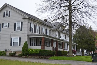
Poland is a village in eastern Mahoning County, Ohio, United States. The population was 2,463 at the 2020 census. A suburb about 7 miles (11 km) south of Youngstown, it is part of the Youngstown–Warren metropolitan area.
Mahoning County is a county in the U.S. state of Ohio. As of the 2020 census, the population was 228,614. Its county seat and largest city is Youngstown. The county is named after the Mahoning River and was formed on March 1, 1846; the 83rd county in Ohio.
Middletown is a village in Logan County, Illinois, United States. The population was 324 at the 2010 census, down from 434 in 2000.
Austintown is an unincorporated community and census-designated place within Austintown Township, Mahoning County, Ohio, United States. The population was 29,594 at the 2020 census. Located directly west of Youngstown, it is a suburb in the Youngstown–Warren metropolitan area.
Beloit is a village in southwestern Mahoning County, Ohio, United States. The population was 903 at the 2020 census. It is part of the Youngstown–Warren metropolitan area.
Campbell is a city in eastern Mahoning County, Ohio, United States, along the Mahoning River. The population was 7,852 at the 2020 census. Located directly southeast of Youngstown, it is a suburb in the Youngstown–Warren metropolitan area.
Canfield is a city in central Mahoning County, Ohio, United States. The population was 7,699 as of the 2020 census. It is a suburb surrounded by Canfield Township located at the intersection of U.S. Routes 62 and 224. It is part of the Youngstown–Warren metropolitan area.
Craig Beach is a village in northwestern Mahoning County, Ohio, United States. Located along the shores of Lake Milton, the population was 1,076 at the 2020 census. It is part of the Youngstown–Warren metropolitan area.
Lowellville is a village in eastern Mahoning County, Ohio, United States, along the Mahoning River. The population was 996 at the 2020 census. Located about 8 miles (13 km) southeast of Youngstown, it is part of the Youngstown–Warren metropolitan area.
Maple Ridge is a census-designated place in southwestern Mahoning County, Ohio, United States, located between Alliance and Sebring. The population was 667 at the 2020 census. It is part of the Youngstown–Warren metropolitan area.
Sebring is a village in southwestern Mahoning County, Ohio, United States. The population was 4,191 as of the 2020 census. It is part of the Youngstown–Warren metropolitan area.
Struthers is a city in eastern Mahoning County, Ohio, United States, along the Mahoning River. The population was 10,063 at the 2020 census. Located directly southeast of Youngstown, it is a suburb in the Youngstown–Warren metropolitan area.
Hubbard is a city in southeastern Trumbull County, Ohio, United States. It is formed from part of Hubbard Township, which was formed from the Connecticut Western Reserve. The population was 7,636 at the 2020 census. It is a suburb in the Youngstown–Warren metropolitan area.
Lordstown is a village in southern Trumbull County, Ohio, United States. The population was 3,332 at the 2020 census. It is part of the Youngstown–Warren metropolitan area.
McDonald is a village in southern Trumbull County, Ohio, United States, along the Mahoning River. The population was 3,172 at the 2020 census. It is a suburb in the Youngstown–Warren metropolitan area.
Newton Falls is a village in southwestern Trumbull County, Ohio, United States. The population was 4,557 at the 2020 census. It is part of the Youngstown–Warren metropolitan area. The city takes its name from the two sets of waterfalls within the village, each on different branches of the Mahoning River. The city is known for its notable ZIP code (44444) and for its covered bridge, which is the second oldest in the state of Ohio.
West Farmington is a village in northwestern Trumbull County, Ohio, United States, along the Grand River. The population was 542 at the 2020 census. It is part of the Youngstown–Warren metropolitan area.
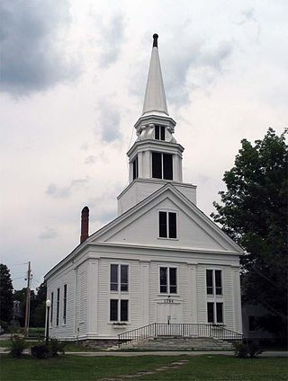
Middletown Springs is a town in Rutland County, Vermont, United States. The population was 794 at the 2020 census.
Washingtonville is a village in northern Columbiana and southern Mahoning counties in the U.S. state of Ohio. The population was 712 at the 2020 census. It is part of the Youngstown–Warren metropolitan area.
Mineral Ridge is an unincorporated community and census-designated place in southern Trumbull and northern Mahoning counties in the U.S. state of Ohio. The population was 3,951 at the 2020 census. It is a suburb in the Youngstown–Warren metropolitan area. Mineral Ridge was named for valuable coal deposits near the original town site.