Nkumba

Last updated
Nkumba
Uganda location map.svg
Red pog.svg
Nkumba
Map of Uganda showing the location of Nkumba
Coordinates: 00°05′36″N32°30′22″E / 0.09333°N 32.50611°E / 0.09333; 32.50611
CountryFlag of Uganda.svg  Uganda
Region Central Uganda
District Wakiso District
County Busiro
Constituency Busiro South
Government
   Member of Parliament Peter Simon Sematimba [1]
Elevation
1,175 m (3,855 ft)
Time zone UTC+3 (EAT)

Nkumba is an urban area in Wakiso District in the Buganda Region of Uganda. [2] The area is primarily a university town, on account of Nkumba University, a private university that maintains its main campus in the neighborhood. [3]

Contents

Location

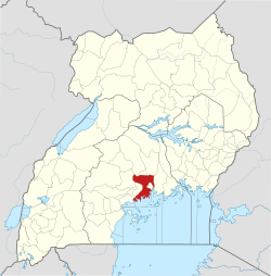
Nkumba is off of the tarmacked Kampala–Entebbe Road. It is approximately 10 kilometres (6 mi), by road, north-east of Entebbe, on the northern shores of Lake Victoria. [3] It lies in Katabi Sub-county, in Busiro County, Wakiso District, in the Buganda Region of Uganda. [4]

The geographical coordinates of Nkumba are 0°05'36.0"N, 32°30'22.0" (Latitude:0.093333; Longitude:32.506111). [5] Nkumba lies at an average elevation of 1,175 metres (3,855 ft), above sea level. [6]

Overview

Nkumba is a mixed-use (commercial and residential), middle class neighborhood. Close to the Kampala–Entebbe Road, the dominant business is the main campus of Nkumba University, with an estimated 12,000 student enrollment. Near the university campus are private student hostels, restaurants, stationery stores, air-time kiosks, banks and related businesses. [3]

Farther inland, away from the highway, the neighbourhood is primarily residential. One can find plots of land for sale, on which to construct a residence, or a business. Closer to the lake, there is potential for resort facilities, which is yet unexploited. [3] Kasenyi Landing Site, a fishing village, lies at the end of the road that connects to Abayita Ababiri, on the Kampala–Entebbe Road. [5]

Prominent people

The paternal grandfather to Queen Sylvia of Buganda, Nelson Edmond Nkalubo Sebugwawo owns a home in Bufulu, Nkumba. Nagginda lived here from the age of about four years of age until the age of about 7 years old, while she attended Lake Victoria Primary School, in nearby Entebbe. [7]

Related Research Articles

Entebbe Place in Uganda

Entebbe is a city in Central Uganda. On a Lake Victoria peninsula, approximately 37 kilometres (23 mi) southwest of the Ugandan capital, Kampala, it was once the seat of government for the Protectorate of Uganda prior to independence, in 1962. Entebbe is the location of Entebbe International Airport, Uganda's largest commercial and military airport, best known for the dramatic rescue of 100 hostages kidnapped by the resistance group of the PFLP-EO and Revolutionary Cells (RZ) organizations. Entebbe is also the location of State House, the official office and residence of the President of Uganda.

Wakiso District District in Uganda

Wakiso District is a district in the Central Region of Uganda that partly encircles Kampala, Uganda's capital city. The town of Wakiso is the site of the district headquarters. Kira, the country's second largest city and suburb of Kampala, is in the district.

Nkumba University (NKU) is a chartered private university in Uganda. It was established in 1994 as part of a group of schools and colleges that originally grew from a kindergarten established in 1951. The university is dedicated to the promotion of excellence in applied business education. The university builds students on the 4Cs: Creativity, Confidence, Competence and Character. The university is not affiliated with any particular religious organization, but it accommodates several religious associations, which allow the students to fellowship along religious beliefs and to devote adequate time to God.

Sylvia Nagginda is the current Nnabagereka or Queen of Buganda, a historic kingdom in modern-day Uganda.

Busega Place in Uganda

Busega is a neighborhood within Kampala, Uganda's capital and largest city.

Lweeza Place in Central Region, Uganda

Lweeza, also Lweza, is a neighborhood in the Buganda Region of Uganda. The correct phonetic spelling consistent with the local Ganda language is Lweeza.

Mutundwe Place in Uganda

Mutundwe is a neighborhood in the town of Ssabagabo in Uganda. The name also refers to Mutundwe Hill, where the neighborhood is located.

The Entebbe–Kampala Expressway, also known as the "Kampala–Entebbe Expressway" or the "Entebbe–Kampala Highway", is a four-lane toll highway in the Central Region of Uganda. The highway links Entebbe International Airport, the country's largest civilian and military airport, to Kampala, the country's capital and largest metropolitan area. Commissioning was originally planned for 2016 but because of the delayed works, commissioning was done on 15 June 2018 by Uganda's sitting President, Yoweri Museveni.

Kyengera Place in Central Region, Uganda

Kyengera is a town in the Central Region of Uganda. It is one of the urban centers in Wakiso District.

Abayita Ababiri Place in Central Uganda, Uganda

Abayita Ababiri, sometimes spelled Abaita Ababiri, is a neighborhood in Uganda.

Buloba Place in Central Uganda, Uganda

Buloba is an urban area in Wakiso District in the Buganda Region of Uganda. The area is primarily a middle-class residential neighborhood.

Kabojja Place in Uganda

Kabojja is a neighborhood in Wakiso District, in the Central Region of Uganda.

Kisubi Place in Central Region of Uganda

Kisubi is a neighborhood in the Central Region of Uganda.

Entebbe General Hospital Hospital in Entebbe, Uganda

Entebbe General Hospital, commonly known as Entebbe Hospital, is a hospital in the town of Entebbe, in the Central Region of Uganda.

Mbalwa Place in Central Region of Uganda, Uganda

Mbalwa is a neighborhood in Kyaliwajjala Parish, Kira Municipality, Wakiso District in the Central Region of Uganda.

Moriah Aviation Training Centre (MATC), is an aviation training school in Uganda, that provides training for prospective pilots, cabin crew staff, aviation customer managers and related courses in the aviation industry.

Kijabijo Place in Buganda, Uganda

Kijabijo is a neighborhood in Kira Town, in Wakiso District in the Buganda Region of Uganda.

Lugonjo Place in Central Uganda, Uganda

Lugonjo is a neighborhood in Entebbe Municipality, Busiro County, Wakiso District, in the Buganda Region of Uganda.

Zana, Uganda Place in Central Uganda, Uganda

Zana is a neighborhood in Ssabagabo Municipality, Kyaddondo County, Wakiso District, in Central Uganda.

Kigo, Uganda Place in Uganda

Kigo is a neighborhood in the town of Ssabagabo in Uganda. The name also refers to Kigo Hill, that forms part of the neighborhood.

References

  1. Chris Kiwawulo (28 February 2020). "MP Sematimba glad it is over". New Vision . Kampala. Retrieved 1 April 2020.
  2. Uganda Travel Guide (2 April 2020). "Profile of Wakiso District". Kampala: Uganda Travel Guide. Retrieved 2 April 2020.
  3. 1 2 3 4 Tony Mushoborozi (1 April 2020). "Nkumba, a town with a lot of potential". Daily Monitor . Kampala. Retrieved 2 April 2020.
  4. Land Conflict Mapping Tool (2 April 2020). "Nkumba Parish, Katabi Sub-county, Wakiso District, Uganda". Land Conflict Mapping Tool. Retrieved 2 April 2020.
  5. 1 2 Google (2 April 2020). "Location of Nkumba, Wakiso District, Uganda" (Map). Google Maps . Google. Retrieved 2 April 2020.
  6. Mapcarta.com (2 April 2020). "The Elevation of Nkumba, Wakiso District, Uganda". Mapcarta.com. Retrieved 2 April 2020.
  7. Christine W. Wanjala (29 July 2013). "Sylvia Nagginda: The Girl Who Became Queen". Daily Monitor . Kampala. Retrieved 2 April 2020.

Coordinates: 00°05′36″N32°30′22″E / 0.09333°N 32.50611°E / 0.09333; 32.50611