
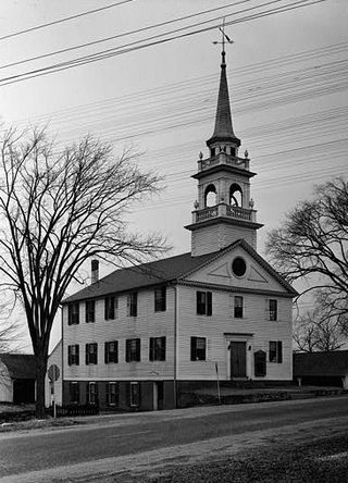
Marycrest College Historic District is located on a bluff overlooking the West End of Davenport, Iowa, United States. The district encompasses the campus of Marycrest College, which was a small, private collegiate institution. The school became Teikyo Marycrest University and finally Marycrest International University after affiliating with a Japanese educational consortium during the 1990s. The school closed in 2002 because of financial shortcomings. The campus has been listed on the Davenport Register of Historic Properties and on the National Register of Historic Places since 2004. At the time of its nomination, the historic district consisted of 13 resources, including six contributing buildings and five non-contributing buildings. Two of the buildings were already individually listed on the National Register.

This is intended to be a complete list of properties and districts listed on the National Register of Historic Places in Orleans County, New York. The locations of National Register properties and districts may be seen in a map by clicking on "Map of all coordinates". Two listings, the New York State Barge Canal and the Cobblestone Historic District, are further designated a National Historic Landmark.

The Oregon Commercial Historic District is a historic district in Oregon, Illinois, that has been listed on the National Register of Historic Places since 2006. The district is roughly bordered by Jefferson, Franklin, 5th and 3rd Streets in Oregon. It is one of six Oregon sites listed on the National Register and one of three to be so listed since the turn of the 21st century. The other two are the Oregon Public Library, listed in 2003, and the Chana School, listed in 2005.
Preston City is a village and the original town center of the town of Preston, Connecticut, United States. The core of the village around the junction of Old Northwest Road and Route 164 is designated as the Preston City Historic District, a historic district that is listed on the National Register of Historic Places. The district is located along Old Shetucket and Amos Roads, which, prior to the 1930s, were major thoroughfares.
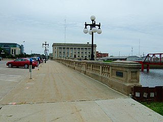
The Civic Center Historic District is located in downtown Des Moines, Iowa, United States. It flanks both the Des Moines and Raccoon Rivers and their confluence. The district has been listed on the National Register of Historic Places since 1988. It is part of The City Beautiful Movement and City Planning in Des Moines, Iowa 1892—1938 MPS.

The Vogel Place Historic District is a nationally recognized historic district located in Ottumwa, Iowa, United States. It was listed on the National Register of Historic Places in 1995. At the time of its nomination it contained 158 resources, which included 101 contributing buildings, six contributing structures, and 51 non-contributing buildings.

The Grinnell Historic Commercial District is a nationally recognized historic district located in Grinnell, Iowa, United States. It was listed on the National Register of Historic Places in 1991. At the time of its nomination it contained 75 resources, which included 47 contributing buildings, and 26 non-contributing buildings. The historic district is the core of the city's central business district. Fires struck the area in 1889 and twice in 1891. They destroyed the frame buildings, and were replaced with brick and stone structures, although Block 7 developed more slowly. Most of the buildings are two stories in height, six buildings are single-story structures, and two are three stories. The economic development of the city was also assisted by the presence of Grinnell College and the presence of two railroads.

The Vander Wilt Farmstead Historic District, also known as the Heritage House Bed and Breakfast, is an agricultural historic district located north of Leighton, Iowa, United States. At the time of its nomination it included three contributing buildings, three contributing structures, one non-contributing building, and two non-contributing structures. The significance of the district is attributed to its association with progressive farming and the Country Life Movement, which sought to improve the living conditions of rural residents. The contributing buildings include the 1904 barn, the house (1920), the corn crib (1953), dairy barn (1955) and the feed lots. The two-story house was built by Douwe Sjaardema, a contractor from Pella, Iowa. The corn crib was built by the Iowa Concrete Crib & Silo Co. of Des Moines. The farm also includes a former landing strip for airplanes. It featured a 1,500-foot (460 m) grass runway where cows grazed on certain days. At one time it had a windsock and homemade landing lights. A hangar, no longer in existence, had been built in 1955. An automobile garage and two silos are the non-contributing resources. The district was listed on the National Register of Historic Places in 2004. The 1904 barn has subsequently been torn down.

Lacey-Keosauqua State Park is located southwest of Keosauqua, Iowa, United States. The park is located along the Des Moines River in Van Buren County. First dedicated in 1921, it is the largest state park in size in Iowa. In 1990, three areas were named nationally recognized historic districts and listed on the National Register of Historic Places.
The Poplar Rural District is a nationally recognized historic district located north of Jacksonville, Iowa, United States. It was listed on the National Register of Historic Places in 1992. At the time of its nomination the district consisted of 55 resources, including 29 contributing buildings, one contributing site, five contributing structures, one contributing object, 15 non-contributing buildings, and four non-contributing structures. The 36 contributing resources include three houses, 12 barns, 14 outbuildings, which are all included as buildings. The three corn cribs and the two granaries/corn cribs are the structures. A concrete post fence line is the object, and the landscape of the district is the site. They are all associated with the largest rural settlement of Danish immigrants in the United States. The farmsteads are located on the hilltops or along the hillsides. The latter appear to be somewhat linked to the ethnic heritage of the Danish immigrants who tended to locate their farmsteads on sheltered hillsides. The period of significance starts with the construction of the original Jackson #1 schoolhouse in 1884, and concludes with the construction of the second Jackson #1 schoolhouse in 1923.

The Reeves Farmstead Historic District was a nationally recognized historic district located north of Le Mars, Iowa, United States. It was listed on the National Register of Historic Places in 2001. At the time of its nomination the district consisted of 13 resources, including 11 contributing buildings, one non-contributing building, and one non-contributing object. The contributing buildings include an American Four Square house, a barn, cob house and wash house, hen house, outhouse, machine shed, corn crib, two hog houses, and a garage. The non-contributing building is a second garage built in the late 20th century, and the non-contributing object is an incomplete wind mill. The buildings were all built in the late 19th- or early 20th century, but exact dates are uncertain. The fully integrated farmstead from the early to mid 20th century features buildings that utilize simple architecture that was typical of many Iowa farms. It was removed from the National Register of Historic Places in 2020.

The Springwells Park Historic District is a historic residential neighborhood located in Dearborn, Michigan and bounded by Rotunda Drive, the Michigan Central Railroad line, and Greenfield and Eastham Roads. The district was listed on the National Register of Historic Places in 2015.

The Lincoln–Fairview Historic District is a nationally recognized historic district located in Council Bluffs, Iowa, United States. It was listed on the National Register of Historic Places in 2007. At the time of its nomination the district consisted of 327 resources, including 264 contributing buildings, two contributing sites, four contributing structures, three contributing objects, 52 non-contributing buildings, and two non-contributing structures. The district is primarily a residential area north of the central business district. It includes the steep loess bluff where President Abraham Lincoln stood to survey the area when he was deciding on the eastern terminus of the Union Pacific Railroad. The Daughters of the American Revolution erected a monument at the location in 1911.

The August H.J. and Justena Lange Farmstead Historic District is an agricultural historic district located northeast of La Porte City, Iowa, United States. It was listed on the National Register of Historic Places in 1997. At the time of its nomination it consisted of 16 resources, which included seven contributing buildings, two contributing structures, one contributing objects, three non-contributing buildings, and three non-contributing structures. The farmstead was developed from 1887, when the Lange's took possession of the property, and 1916 when they moved into La Porte City. They had a general farming operation here that was augmented by August's specialized skill as a blacksmith. The farmstead was organized spatially with the domestic buildings on the west side of Spring Creek Road and the farming operation on the east side.

The Mason City Downtown Historic District is a nationally recognized historic district located in Mason City, Iowa, United States. It was listed on the National Register of Historic Places in 2005. At the time of its nomination it contained 93 resources, which included 63 contributing buildings, one contributing site, four objects, 22 non-contributing buildings, and three non-contributing objects. Platted in 1855, Mason City is a commercial and industrial center for north central Iowa. It was also a railroad center, but the tracks bypassed the central business district in order to serve the industries located on the north side of town and the wholesale enterprises on the south side. Central Park, a public square, was part of the city's original plat and is the contributing site.

Bandshell Park, also known as City Park and Music Pavilion, is located in Ames, Iowa, United States. It is a nationally recognized historic district that was listed on the National Register of Historic Places in 1999. At the time of its nomination it consisted of six resources, which included one contributing building, one contributing site, two contributing structures, one contributing object, and one non-contributing object. The park, located to the east of the central business district, was gift to the city in 1884 from the C&NW Land Company. The full city block was the first park established in Ames.

The Marion Commercial Historic District is a nationally recognized historic district located in Marion, Iowa, United States. It was listed on the National Register of Historic Places in 2009. At the time of its nomination it consisted of 41 resources, which included 29 contributing buildings, one contributing site, one contributing structure, two contributing objects, and eight non-contributing buildings. The historic district covers the city's central business district. The development of this area largely occurred when Marion was the county seat of Linn County (1838-1919). There are no county government buildings extant from this era. The city was also a division point for the Chicago, Milwaukee, St. Paul and Pacific Railroad in the late nineteenth and early twentieth centuries.
Fred Maytag Park is a public park located in Newton, Iowa, United States. It was listed as a historic district on the National Register of Historic Places in 2010. At the time of its nomination it contained 39 resources, which included seven contributing buildings, nine contributing sites, eight contributing structures, four contributing objects, four non-contributing buildings, two non-contributing sites, three non-contributing structures, and two non-contributing objects. The park was a gift from F.L. Maytag, founder of the Maytag Company, to the people of Newton. It is significant as an example of a privately funded public park during the Great Depression. The 40-acre (16 ha) partial of land was acquired by Maytag in 1935. It had previously served as the fairgrounds owned by the Jasper County Agricultural Society. He made an agreement with the city council that the park would be privately owned and operated, but open for public use. The city was required to provide water and electricity. It remained a privately owned park until 1977 when it was conveyed to the city.

The Pontiac Commercial Historic District is a primarily commercial historic district located roughly along East Huron and South Saginaw Streets, within loop of Wide Track Drive, in Pontiac, Michigan. The core of the district, within the block bounded by Saginaw, Lawrence, Pike, and Wayne Streets, was originally listed on the National Register of Historic Places in 1984. A boundary increase creating the present boundaries was listed in 1989. The district includes the Eagle Theater and the Grinnell Brothers Music House, also listed on the National Register.
The Meyers Farmstead Historic District, also known as the Jacob E. and Amanda Meyers Farm and the John B. and Ella Meyers Farm, is an agricultural historic district located in Lisbon, Iowa, United States. It was listed on the National Register of Historic Places in 2021. At the time of its nomination it consisted of six resources, which included two contributing buildings, two contributing structures, and two contributing objects. The historic buildings include a heavy timber frame Pennsylvania banked barn (1870s) and a feeder/hay barn. The historic structures include a combination corn crib/hog house (1880s) and a concrete silo. The contributing objects include a concrete watering trough and water pump and a metal gateway. The farmhouse is also extant but was separated from the rest of the farm buildings when South Jefferson Street was extended in 2002. That separation and the modifications made to it over the years has led to its loss of historical integrity


