Notasulga, Alabama

Last updated

Notasulga
Notasulga1.JPG
Notasulga in 2007
Lee County and Macon County Alabama Incorporated and Unincorporated areas Notasulga Highlighted 0155440.svg
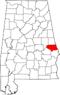
Macon County, Alabama
Coordinates: 32°33′39″N85°40′3″W / 32.56083°N 85.66750°W / 32.56083; -85.66750
Country United States
State Alabama
Counties Macon, Lee
Government
  MayorTommy Miller [1]
Area
[2]
  Total14.12 sq mi (36.57 km2)
  Land13.97 sq mi (36.17 km2)
  Water0.15 sq mi (0.40 km2)
Elevation
512 ft (156 m)
Population
 (2020) [3]
  Total914
  Density65.4/sq mi (25.27/km2)
Time zone UTC-6 (CST)
  Summer (DST) UTC-5 (CDT)
ZIP code
36866
Area code 334
FIPS code 01-55440
GNIS feature ID0152715
Website Notasulga

Notasulga is a town in Macon and Lee counties in the U.S. state of Alabama. As of the 2020 census, the population of the town was 914. [3] The portion in Lee County is part of the Auburn Metropolitan Area. According to the 1910 U.S. Census, it incorporated in 1893. [4] Author Zora Neale Hurston was born in Notasulga in 1891. The town name comes from the Creek words noti sulgi, which means "many teeth". [5]

Contents

Geography

Notasulga is located in northern Macon County at 32°33′39″N85°40′3″W / 32.56083°N 85.66750°W / 32.56083; -85.66750 (32.560821, -85.667631). [6] The town extends northeast into the western part of Lee County.

According to the U.S. Census Bureau, the town has a total area of 14.1 square miles (36.6 km2), of which 14.0 square miles (36.2 km2) are land and 0.2 square miles (0.4 km2), or 1.09%, are water. [2] The center of town is on a height of land, draining north to Sougahatchee Creek, a west-flowing tributary of the Tallapoosa River, and south to Red Creek, a tributary of Uphapee Creek, which also flows west to the Tallapoosa.

Demographics

Historical population
CensusPop.Note
1880 236
1890 33240.7%
1910 512
1920 61920.9%
1930 75622.1%
1940 86314.2%
1950 816−5.4%
1960 8848.3%
1970 833−5.8%
1980 8765.2%
1990 97911.8%
2000 916−6.4%
2010 9655.3%
2020 914−5.3%
U.S. Decennial Census [7]
2013 Estimate [8]

As of the census [9] of 2000, there were 916 people, 393 households, and 260 families residing in the town. The population density was 65.9 inhabitants per square mile (25.4/km2). There were 446 housing units at an average density of 32.1 per square mile (12.4/km2). The racial makeup of the town was 66.27% White, 32.42% Black or African American, 0.22% Native American, 0.55% from other races, and 0.55% from two or more races. 0.76% of the population were Hispanic or Latino of any race.

There were 393 households, out of which 26.2% had children under the age of 18 living with them, 48.6% were married couples living together, 14.0% had a female householder with no husband present, and 33.6% were non-families. 29.5% of all households were made up of individuals, and 11.5% had someone living alone who was 65 years of age or older. The average household size was 2.33 and the average family size was 2.87.

In the town, the population was spread out, with 23.4% under the age of 18, 7.8% from 18 to 24, 24.8% from 25 to 44, 28.2% from 45 to 64, and 15.9% who were 65 years of age or older. The median age was 40 years. For every 100 females, there were 86.6 males. For every 100 females age 18 and over, there were 81.9 males.

The median income for a household in the town was $31,307, and the median income for a family was $34,479. Males had a median income of $27,500 versus $18,684 for females. The per capita income for the town was $17,115. About 10.7% of families and 17.8% of the population were below the poverty line, including 20.8% of those under age 18 and 11.2% of those age 65 or over.

Government

Notasulga elects a mayor and five city council members every four years.

2017 Mayor and Council: [10]

Notable people

Related Research Articles

<span class="mw-page-title-main">Bullock County, Alabama</span> County in Alabama, United States

Bullock County is a county of the U.S. state of Alabama. As of the 2020 census, the population was 10,357. Union Springs was chosen as the county seat in 1867, and presently is the county's only incorporated city. The county was named for Confederate Army Colonel Edward C. Bullock who was a state senator and outspoken secessionist who died during the American Civil War.

<span class="mw-page-title-main">Lee County, Alabama</span> County in Alabama, United States

Lee County is a county located in east central Alabama. As of the 2020 census the population was 174,241. The county seat is Opelika, and the largest city is Auburn. The county was established in 1866 and is named for General Robert E. Lee (1807–1870), who served as General in Chief of the Armies of the Confederate States in 1865. Lee County comprises the Auburn-Opelika, AL Metropolitan Statistical Area, which is included in the Columbus-Auburn-Opelika, GA-AL Combined Statistical Area.

<span class="mw-page-title-main">Macon County, Alabama</span> County in Alabama, United States

Macon County is a county located in the east central part of the U.S. state of Alabama. As of the 2020 census, the population was 19,532. Its county seat is Tuskegee. Its name is in honor of Nathaniel Macon, a member of the United States Senate from North Carolina.

<span class="mw-page-title-main">Randolph County, Alabama</span> County in Alabama, United States

Randolph County is a county on the central eastern border of the U.S. state of Alabama. As of the 2020 census, the population was 21,967. Its county seat is Wedowee. Its name is in honor of John Randolph, a member of the United States Senate from Virginia. Randolph County was a prohibition or dry county until 2012, when the citizens of Randolph County voted to repeal prohibition.

<span class="mw-page-title-main">Tallapoosa County, Alabama</span> County in Alabama, United States

Tallapoosa County is located in the east-central portion of the U.S. state of Alabama. As of the 2020 census, the population was 41,311. Its county seat is Dadeville. Its largest city is Alexander City.

<span class="mw-page-title-main">Tallassee, Alabama</span> City in Alabama, United States

Tallassee is a city on the Tallapoosa River, located in both Elmore and Tallapoosa counties in the U.S. state of Alabama. At the 2020 census, the population was 4,763. It is home to a major hydroelectric power plant at Thurlow Dam operated by Alabama Power Company.

<span class="mw-page-title-main">Auburn, Alabama</span> City in Alabama, United States

Auburn is a city in Lee County, Alabama, United States. It is the largest city in eastern Alabama. The population was 76,143 at the 2020 census. It is a principal city of the Auburn-Opelika Metropolitan Area. The Auburn-Opelika, AL MSA with a 2020 population of 193,773, along with the Columbus, GA-AL MSA and Tuskegee, Alabama, comprises the greater Columbus-Auburn-Opelika, GA-AL CSA, a region home to 563,967 residents as of 2020.

<span class="mw-page-title-main">Franklin, Alabama</span> Town in Alabama, United States

Franklin is a rural town in Macon County, Alabama, United States. As of the 2020 census, the population was 590.

<span class="mw-page-title-main">Shorter, Alabama</span> Town in Alabama, United States

Shorter is a town in Macon County, Alabama, United States. At the 2020 census the population was 385, down from 474 at the 2010 census. According to the 1990 U.S. Census records, it was incorporated in 1984.

<span class="mw-page-title-main">Roanoke, Alabama</span> City in Alabama, United States

Roanoke is a city in Randolph County, which is in the Piedmont region of eastern Alabama, United States. As of the 2020 census, the population of the city was 5,311, down from 6,074 in 2010 and 6,563 in 2000.

<span class="mw-page-title-main">Wadley, Alabama</span> Town in Alabama, United States

Wadley is a town in Randolph County, Alabama, United States. It is home to the Wadley campus of Southern Union State Community College. As of the 2010 census, the population of the town was 751, up from 640 in 2000. According to the 1910 U.S. Census, the town was incorporated in 1908.

<span class="mw-page-title-main">Alexander City, Alabama</span> City in Alabama, United States

Alexander City, known to locals as "Alex City", is the largest city in Tallapoosa County, Alabama, United States, with a population of 14,843 as of the 2020 census. It has been the largest community in Tallapoosa County since 1910. It is known for Lake Martin with its 750 miles (1,210 km) of wooded shoreline and 44,000 acres (18,000 ha) of water. Lake Martin stands on the Tallapoosa River and offers boating, swimming, fishing, golfing, and camping. Many neighborhoods and luxury homes are located on the lake.

<span class="mw-page-title-main">Camp Hill, Alabama</span> Town in Alabama, United States

Camp Hill is a town in Tallapoosa County, Alabama, United States. It was incorporated in 1895. At the 2010 census the population was 1,014, down from 1,273 in 2000. Camp Hill is the home to Southern Preparatory Academy.

<span class="mw-page-title-main">Dadeville, Alabama</span> County seat of Tallapoosa County

Dadeville is a city in and the county seat of Tallapoosa County, Alabama, United States. At the 2010 census the population was 3,230, up from 3,212 in 2000.

<span class="mw-page-title-main">Jackson's Gap, Alabama</span> Town in Alabama, United States

Jackson's Gap is a town in Tallapoosa County, Alabama, United States. It incorporated in 1980. At the 2010 census the population was 828, up from 761.

<span class="mw-page-title-main">Tamiami, Florida</span> Census-designated place in Florida

Tamiami is a census-designated place (CDP) in Miami-Dade County, Florida, United States. It is part of the Miami metropolitan area of South Florida. The population was 54,212 at the 2020 census.

<span class="mw-page-title-main">Eatonville, Florida</span> Town in Florida, United States

Eatonville is a town in Orange County, Florida, United States, six miles north of Orlando. It is part of Greater Orlando. Incorporated on August 15, 1887, it was one of the first self-governing all-black municipalities in the United States. The Eatonville Historic District and Moseley House Museum are in Eatonville. Author Zora Neale Hurston grew up in Eatonville and the area features in many of her stories.

<span class="mw-page-title-main">Tallapoosa, Georgia</span> City in Georgia, United States

Tallapoosa is a city in Haralson County, Georgia. The population was 3,170 at the 2010 census, up from 2,789 at the 2000 census.

<span class="mw-page-title-main">Waco, Georgia</span> City in Georgia, United States

Waco is a city in Haralson County, Georgia, United States, located near the Alabama state line. The population was 516 at the 2010 census, up from 469 at the 2000 census.

<span class="mw-page-title-main">Tallapoosa, Missouri</span> City in Missouri, United States

Tallapoosa is a city in New Madrid County, Missouri, United States. The population was 78 at the 2020 census.

References

  1. Ly, My (April 21, 2022). "Five East Alabama mayors endorse Ivey for reelection". The Plainsman. Retrieved April 25, 2022.
  2. 1 2 "2020 U.S. Gazetteer Files". United States Census Bureau. Retrieved October 29, 2021.
  3. 1 2 "Notasulga town, Alabama: 2020 DEC Redistricting Data (PL 94-171)". U.S. Census Bureau. Retrieved March 31, 2022.
  4. "Thirteenth Census of the United States Taken in the Year 1910: Statistics for Alabama Containing Statistics of Population, Agriculture, Manufactures, and Mining for the State, Counties, Cities, and Other Divisions". 1913.
  5. William A. Read (1994). "Southeastern Indian Place Names in what is now Alabama" (PDF). Indian Place Names in Alabama. Alabama Department of Archives and History. Retrieved January 22, 2023.
  6. "US Gazetteer files: 2010, 2000, and 1990". United States Census Bureau. February 12, 2011. Retrieved April 23, 2011.
  7. "U.S. Decennial Census". Census.gov. Retrieved June 6, 2013.
  8. "Annual Estimates of the Resident Population: April 1, 2010 to July 1, 2013" . Retrieved June 3, 2014.
  9. "U.S. Census website". United States Census Bureau . Retrieved January 31, 2008.
  10. "Notasulga, Alabama: Elected Officials" . Retrieved February 6, 2022.
  11. Valerie Boyd (October 4, 2011). Wrapped in Rainbows: The Life of Zora Neale Hurston. Simon and Schuster. p. 19. ISBN   978-1-4391-2541-0.

32°33′39″N85°40′03″W / 32.560821°N 85.667631°W / 32.560821; -85.667631