O'Fallon, St. Louis

Last updated
O'Fallon
Awnings in the O'Fallon Neighborhood (8410146576).jpg
Houses in O'Fallon, January 2013
STL Neighborhood Map 68.PNG
Location (red) of O'Fallon within St. Louis
Country United States
State Missouri
City St. Louis
Wards 21
Government
  AldermenJohn Collins-Muhammad, II
Area
  Total0.59 sq mi (1.5 km2)
Population
 (2020) [1]
  Total4,342
  Density7,400/sq mi (2,800/km2)
ZIP code(s)
Parts of 63107, 63115
Area code(s) 314
Website stlouis-mo.gov

O'Fallon is a neighborhood of St. Louis, Missouri. The neighborhood is located on the north side of the City of St. Louis, nestled between O'Fallon Park and Fairground Park. It is bounded by West Florissant, Harris Avenue, Algernon Street and Adelaide on the north, Pope Avenue on the northwest, Kossuth and Natural Bridge Avenues on the south via Fair Avenue, Warne on the east, and Newstead on the west. The O'Fallon neighborhood is located in the 21st Ward which is currently represented by Alderman John Collins-Muhammad.

Contents

Characteristics

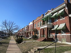
The O'Fallon neighborhood is anchored by two major public parks, O'Fallon Park and Fairground Park. The area is primarily a residential neighborhood with streets lined with brick and frame single-family homes, two-family homes, and a few multi-family buildings. Many of the housing units are owner-occupied, but there is a visibly large amount of abandoned, crumbling buildings and vacant lots. Ones that have been maintained are pleasant brick homes with well-tended porches. The neighborhood has not remained relatively stable thanks to many multi-generation residents in social gridlock and a high percentage of African Americans under the poverty line. [2]

Demographics

Historical population
CensusPop.Note
1990 8,901
2000 7,151−19.7%
2010 5,791−19.0%
2020 4,342−25.0%
Sources: [3] [4]

In 2020 the racial makeup of O'Fallon was 95.2% Black, 1.3% White, 0.5% Asian, 0.3% Native American, 2.5% Two or More Races, and 0.6% Some Other Race. 0.8% of the population was of Hispanic or Latino origin. [5]

See also

Related Research Articles

<span class="mw-page-title-main">O'Fallon, Illinois</span> City in Illinois, United States

O'Fallon is a city in St. Clair County, Illinois, United States. The 2020 census listed the population at 32,289. The city is the second largest city in the Metro East region and Southern Illinois. It sits 5 miles (8.0 km) from Scott Air Force Base and 18 miles (29 km) from Downtown St Louis.

<span class="mw-page-title-main">Clayton, Missouri</span> City in Missouri, United States

Clayton is a city in and the county seat of St. Louis County, Missouri, and borders the independent city of St. Louis. The population was 17,355 at the 2020 census. Organized in 1877, the city was named after Ralph Clayton, who donated the land for the St. Louis County courthouse.

<span class="mw-page-title-main">The Ville, St. Louis</span> Neighborhood of St. Louis in Missouri, United States

The Ville is a historic African-American neighborhood with many African-American businesses located in North St. Louis, Missouri, U.S.. This neighborhood is a forty-two-square-block bounded by St. Louis Avenue on the north, Martin Luther King Drive on the south, Sarah on the east and Taylor on the west. From 1911 to 1950, The Ville was the center of African American culture within the city of St. Louis.

<span class="mw-page-title-main">Old North St. Louis</span> Neighborhood of St. Louis in Missouri, United States

Old North St. Louis is a neighborhood just north and slightly west of the downtown area of St. Louis, Missouri. It is known for Crown Candy Kitchen, historic 19th-century brick homes, and its community gardens.

<span class="mw-page-title-main">Shaw, St. Louis</span> Neighborhood of St. Louis in Missouri, United States

Shaw is a neighborhood in St. Louis, Missouri. It is bordered on the North by Interstate 44, the east by S. Grand Blvd, the west by Tower Grove Ave and the Missouri Botanical Gardens, and the south by Tower Grove Park. The Shaw Neighborhood is a local historic district whose historic structure and character is protected by ordinance.

<span class="mw-page-title-main">Baden, St. Louis</span> Neighborhood of St. Louis in Missouri, United States

Baden is a neighborhood of St. Louis, Missouri.

<span class="mw-page-title-main">Clifton Heights, St. Louis</span> Neighborhood of St. Louis in Missouri, United States

Clifton Heights is a neighborhood of St. Louis, Missouri, US, located along the southwest border of the city and highlighted by a park — Clifton Park (38.6143°N 90.2916°W) — with a playground and a lake.

<span class="mw-page-title-main">Carr Square, St. Louis</span> Neighborhood of St. Louis in Missouri, United States

Carr Square is a neighborhood of St. Louis, Missouri. The Downtown neighborhood is bounded by Cass Avenue on the North, Carr Street on the South, North Tucker Boulevard and North 13th Street on the East, and North Jefferson on the West.

<span class="mw-page-title-main">College Hill, St. Louis</span> Neighborhood of St. Louis in Missouri, United States

College Hill is a neighborhood of the City of St. Louis, Missouri. The name College Hill was given to this area because it was the location of the Saint Louis University College Farm. This area, bounded generally by Warne Ave., O'Fallon Park, I-70, Grand Boulevard, and W. Florissant Ave., was acquired by the University for garden and recreation purposes in 1836. It was subdivided in the early 1870s.

<span class="mw-page-title-main">DeBaliviere Place, St. Louis</span> Neighborhood of St. Louis in Missouri, United States

DeBaliviere Place is a neighborhood of St. Louis, Missouri.

<span class="mw-page-title-main">Fairground, St. Louis</span> Neighborhood of St. Louis in Missouri, United States

Fairground is a neighborhood of St. Louis, Missouri. The neighborhood's boundaries are defined as Glasgow Avenue on the east, west and North Florissant Avenues on the north, Warne on the west, and Fairground Park and Natural Bridge Avenue on the south.

<span class="mw-page-title-main">Hi-Pointe, St. Louis</span> Neighborhood of St. Louis in Missouri, United States

Hi-Pointe is a neighborhood of St. Louis, Missouri, within a section known as Dogtown. It is bounded by Clayton Avenue and Oakland Avenue on the north, City Limits on the west, Dale Avenue on the south, and Louisville Avenue on the east. It is bordered by the Skinker-DeBaliviere neighborhood and Forest Park on the north, the Clayton-Tamm neighborhood on the east, the Franz Park neighborhood on the south and the city of Richmond Heights, part of St. Louis County on the west.

<span class="mw-page-title-main">St. Louis Hills, St. Louis</span> Neighborhood of St. Louis in Missouri, United States

St. Louis Hills is a neighborhood in St. Louis, Missouri. The neighborhood, which is home to the Chippewa location of Ted Drewes Frozen Custard, is situated in the southwest part of St. Louis. It is bounded by Chippewa Street to the northwest and north, Hampton Avenue to the east, Gravois Avenue to the southeast, and the St. Louis county border to the southwest.

<span class="mw-page-title-main">Kingsway East, St. Louis</span> Neighborhood of St. Louis in Missouri, United States

Kingsway East is a neighborhood of St. Louis, Missouri. The neighborhood is generally defined by Natural Bridge on the North, Martin Luther King on the South, Marcus Avenue on the East, and Kingshighway on the West.

<span class="mw-page-title-main">Lindenwood Park, St. Louis</span> Neighborhood of St. Louis in Missouri, United States

Lindenwood Park is a neighborhood of St. Louis, Missouri. The Lindenwood Neighborhood is defined by Arsenal Street and I-44 to the north, Watson and Chippewa Street to the south, Hampton Avenue on the east and the city limits to the west.

<span class="mw-page-title-main">Marine Villa, St. Louis</span> Neighborhood of St. Louis in Missouri, United States

Marine Villa is a neighborhood of St. Louis, Missouri. The neighborhood is located just south of the large and historic Anheuser-Busch Brewery complex along the bluffs of the Mississippi River. It is further defined by Cherokee Street's Antique Row on the north, Gasconade Street on the south, South Broadway and Jefferson Avenue on the west, and the Mississippi River on the east.

<span class="mw-page-title-main">North Hampton, St. Louis</span> Neighborhood of St. Louis in Missouri, United States

North Hampton is a neighborhood of St. Louis, Missouri. Located in Southwest City, North Hampton is bounded by Scanlan and Connecticut to the north, South Kingshighway Boulevard to the east, Chippewa Street to the south, and Hampton Avenue to the west.

<span class="mw-page-title-main">Southwest Garden, St. Louis</span> Neighborhood of St. Louis in Missouri, United States

Southwest Garden is a neighborhood of St. Louis, Missouri, located south of The Hill and Forest Park Southeast, west of the Missouri Botanical Garden and Tower Grove Park, east of Lindenwood Park and Clifton Heights, and north of North Hampton.

<span class="mw-page-title-main">Penrose, St. Louis</span> Neighborhood of St. Louis in Missouri, United States

Penrose is a neighborhood of St. Louis, Missouri. The neighborhood is located on the north side of the city just south of Interstate 70 and west of O’Fallon Park. It is bounded by Florissant Avenue and I-70 on the north, Natural Bridge on the south, North Newstead and Pope Avenue on the east, and Kingshighway Boulevard on the west.

<span class="mw-page-title-main">Princeton Heights, St. Louis</span> Neighborhood of St. Louis in Missouri, United States

Princeton Heights is a neighborhood of St. Louis, Missouri. The neighborhood boundaries are defined as Hampton Boulevard on the west, Eichelberger on the north, Christy Boulevard on the east, and Gravois on the south.

References

  1. Census Summary By Neighborhoods
  2. O'Fallon Neighborhood: Characteristics
  3. "O'Fallon Neighborhood Statistics". St Louis, MO. Retrieved 14 February 2023.
  4. "Neighborhood Census Data". City of St. Louis. Retrieved 26 January 2023.
  5. "City of St. Louis" (PDF). Retrieved 2021-09-26.

38°40′23″N90°13′39″W / 38.6730°N 90.2275°W / 38.6730; -90.2275