Oakwood, Queensland

Last updated

Oakwood
Queensland
Oakwood State School, 2024.jpg
Oakwood State School, 2024
Australia Queensland location map.svg
Red pog.svg
Oakwood
Coordinates 24°50′55″S152°17′53″E / 24.8486°S 152.2980°E / -24.8486; 152.2980 (Oakwood (centre of locality))
Population364 (2021 census) [1]
 • Density31.38/km2 (81.3/sq mi)
Postcode(s) 4670
Elevation21.6 m (71 ft)
Area11.6 km2 (4.5 sq mi)
Time zone AEST (UTC+10:00)
Location
LGA(s) Bundaberg Region
State electorate(s) Burnett
Federal division(s) Flynn
Mean max tempMean min tempAnnual rainfall
 ??1,010 mm
39.8 in
Suburbs around Oakwood:
Meadowvale Meadowvale Gooburrum
Sharon Oakwood Bundaberg North
Sharon Avoca Millbank

Oakwood is a rural locality in the Bundaberg Region, Queensland, Australia. [2] In the 2021 census, Oakwood had a population of 364 people. [1]

Contents

Geography

Burnett River, near Oakwood Sugar Mill ca.1909 StateLibQld 1 395677 Burnett River, Bundaberg, Queensland, 1909.jpg
Burnett River, near Oakwood Sugar Mill ca.1909

Oakwood is bounded on the south by the Burnett River and on the west by Splitters Creek. The North Coast railway line forms its north-eastern border, but no railway stations serve the locality. [3]

Camp Island ( 24°51′53″S152°17′56″E / 24.8648°S 152.2989°E / -24.8648; 152.2989 (Camp Island) ) in the Burnett River is within the locality's borders. [3]

The land use is mostly agricultural, involving irrigated cropping and some grazing. Unlike many farming areas near Bundaberg, sugarcane is growing in Oakwood but not as the predominant crop. [3]

The Bundaberg-Gin Gin Road (State Route 3) runs through from east to west, and the Bundaberg-Miriam Vale Road exits to the north. [4]

Climate

Oakwood has a subtropical climate with wet, hot summers and mild winters. The annual rainfall of Oakwood is about 1010 mm. The most rain received by Oakwood in a day was 258 mm. The most rain received by Oakwood in a September day was around 125 mm. [5]

History

Dam and canefields, Oakwood Sugar Mill ca.1909 StateLibQld 2 395693 Dam and canefields, Oakwood Sugar Mill, Bundaberg, Queensland, 1909.jpg
Dam and canefields, Oakwood Sugar Mill ca.1909

A church had been established by 1909 and had been offered to the Presbyterian Church on the condition they held regular services. [6] [7] Presbyterian services were conducted there until at least 1923. [8] At some later time, the Methodist Church bought the church and replaced it with a new church in 1936. [9] The Methodists operated the church until at least 1976. [10]

Oakwood State School opened on 24 March 1924 under head teacher James Whalley. [11] [12] The school celebrated its centenary in 2024. [13]

Demographics

In the 2011 census, Oakwood had a population of 341 people. [14]

In the 2016 census, Oakwood had a population of 331 people. [15]

In the 2021 census, Oakwood had a population of 364 people. [1]

Heritage listings

Splitters Creek Railway Bridge Dia 0376.jpg
Splitters Creek Railway Bridge

Oakwood has the following heritage listings:

Education

Oakwood State School is a government primary (Prep-6) school for boys and girls at 125 Oakwood School Road ( 24°50′40″S152°18′01″E / 24.8445°S 152.3004°E / -24.8445; 152.3004 (Oakwood State School) ). [17] [18] In 2017, the school had an enrolment of 101 students with 7 teachers (6 full-time equivalent) and 10 non-teaching staff (5 full-time equivalent). [19] In 2018, the school had an enrolment of 115 students with 9 teachers (7 full-time equivalent) and 9 non-teaching staff (5 full-time equivalent). [20]

There is no secondary school in Oakwood. The nearest government secondary school is Bundaberg North State High School in neighbouring Bundaberg North to the east. [3]

Amenities

The Oakwood Community Church is a non-denominational church at 544 Gin Gin Road ( 24°51′04″S152°18′24″E / 24.8510°S 152.3068°E / -24.8510; 152.3068 (Oakwood Community Church) ). It is affiliated with the Christian Community Churches of Australia. [21] [22] Oakwood's Queensland Country Women's Association hall is immediately adjacent to the west at 548 Gin Gin Road ( 24°51′03″S152°18′23″E / 24.8508°S 152.3064°E / -24.8508; 152.3064 (Oakwood CWA hall) ). [23]

The Oakwood State School also serves as a place where the local families gather. [24]

The Oakwood branch of the Queensland Country Women's Association meets at the Kenmore Library at the CWA Hall at 550 Mount Perry Road. [25]

Sport

Tourism

Oakwood Caravan Park, provides accommodation with caravan berths and cabins for rent.

SSS Strawberries is a large strawberry farm that has a strawberry shop and opportunities to pick-your-own strawberries. [26]

See also

Related Research Articles

<span class="mw-page-title-main">Childers, Queensland</span> Town in Queensland, Australia

Childers is a rural town and locality in the Bundaberg Region, Queensland, Australia. In the 2021 census, the locality of Childers had a population of 1,682 people.

<span class="mw-page-title-main">Gin Gin, Queensland</span> Town in Queensland, Australia

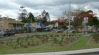
Gin Gin is a rural town and locality in the Bundaberg Region, Queensland, Australia. In the 2021 census, the locality of Gin Gin had a population of 1,139 people.

<span class="mw-page-title-main">Mount Perry, Queensland</span> Town in Queensland, Australia

Mount Perry is a rural town and locality in the North Burnett Region, Queensland, Australia. In the 2021 census, the locality of Mount Perry had a population of 487 people.

<span class="mw-page-title-main">Burnett Heads, Queensland</span> Town in Queensland, Australia

Burnett Heads is a coastal town and locality in the Bundaberg Region, Queensland, Australia. In the 2021 census, the locality of Burnett Heads had a population of 2,908 people.

<span class="mw-page-title-main">Bundaberg Region</span> Local government area in Queensland, Australia

The Bundaberg Region is a local government area in the Wide Bay–Burnett region of Queensland, Australia, about 360 kilometres (220 mi) north of Brisbane, the state capital. It is centred on the city of Bundaberg, and also contains a significant rural area surrounding the city. It was created in 2008 from a merger of the City of Bundaberg with the Shires of Burnett, Isis and Kolan.

<span class="mw-page-title-main">Moore Park Beach, Queensland</span> Town in Queensland, Australia

Moore Park Beach is a coastal rural locality in the Bundaberg Region, Queensland, Australia. The coastal town of Moore Park is within the locality.

<span class="mw-page-title-main">Bundaberg Central, Queensland</span> Suburb of Bundaberg, Queensland, Australia

Bundaberg Central is the central suburb and central business district of Bundaberg in the Bundaberg Region, Queensland, Australia. In the 2021 census, Bundaberg Central had a population of 162 people.

<span class="mw-page-title-main">South Kolan</span> Town in Queensland, Australia

South Kolan is a rural locality in the Bundaberg Region, Queensland, Australia. In the 2021 census, the locality of South Kolan had a population of 1,258 people.

<span class="mw-page-title-main">Bundaberg North, Queensland</span> Suburb of Bundaberg, Queensland, Australia

Bundaberg North is a suburb of Bundaberg in the Bundaberg Region, Queensland, Australia. It occupies the developed area north of the Burnett River, opposite the Bundaberg CBD. In the 2021 census, Bundaberg North had a population of 5,563 people.

South Bingera is a rural residential locality in the Bundaberg Region, Queensland, Australia. In the 2021 census, South Bingera had a population of 674 people.

<span class="mw-page-title-main">Bundaberg East</span> Suburb of Bundaberg, Queensland, Australia

Bundaberg East is a suburb of Bundaberg in the Bundaberg Region, Queensland, Australia. In the 2021 census, Bundaberg East had a population of 2,839 people.

<span class="mw-page-title-main">Kalkie, Queensland</span> Suburb of Bundaberg, Queensland, Australia

Kalkie is a suburb of Bundaberg in the Bundaberg Region, Queensland, Australia. In the 2021 census, Kalkie had a population of 2,968 people.

<span class="mw-page-title-main">Millbank, Queensland</span> Suburb of Bundaberg, Queensland, Australia

Millbank is a mixed-use suburb in the Bundaberg Region, Queensland, Australia. In the 2021 census, Millbank had a population of 2,499 people.

Sharon is a rural locality in the Bundaberg Region, Queensland, Australia. In the 2021 census, Sharon had a population of 1,209 people.

Bungadoo is a rural locality in the Bundaberg Region, Queensland, Australia. The area was formerly known as Albionville. In the 2021 census, Bungadoo had a population of 342 people.

<span class="mw-page-title-main">Bucca, Queensland</span> Suburb of Bundaberg Region, Queensland, Australia

Bucca is a rural locality in the Bundaberg Region, Queensland, Australia. In the 2021 census, Bucca had a population of 1,063 people.

Welcome Creek is a rural locality in the Bundaberg Region, Queensland, Australia. In the 2021 census, Welcome Creek had a population of 421 people.

Good Night is a rural locality split between the Bundaberg Region and the North Burnett Region, Queensland, Australia. It is also written as Goodnight. In the 2021 census, Good Night had a population of 151 people.

Morganville is a rural locality in the Bundaberg Region, Queensland, Australia.

Monduran is a rural locality in the Bundaberg Region, Queensland, Australia. In the 2021 census, Monduran had a population of 84 people.

References

  1. 1 2 3 Australian Bureau of Statistics (28 June 2022). "Oakwood (SAL)". 2021 Census QuickStats. Retrieved 28 February 2023. OOjs UI icon edit-ltr-progressive.svg
  2. "Oakwood – locality in Bundaberg Region (entry 48371)". Queensland Place Names. Queensland Government . Retrieved 6 March 2022.
  3. 1 2 3 4 "Queensland Globe". State of Queensland . Retrieved 2 August 2022.
  4. Google (31 October 2023). "Oakwood, Queensland" (Map). Google Maps . Google. Retrieved 31 October 2023.
  5. "Frequently asked questions about Oakwood, QLD". bonzle.com. Archived from the original on 2 August 2022. Retrieved 29 September 2015.
  6. "Family Notices". The Bundaberg Mail And Burnett Advertiser . No. 3696. Queensland, Australia. 8 February 1909. p. 2. Archived from the original on 2 August 2022. Retrieved 2 August 2022 via National Library of Australia.
  7. "ST. ANDREW'S PRESBYTERIAN CHURCH". The Bundaberg Mail And Burnett Advertiser . Vol. 44, no. 5319. Queensland, Australia. 16 May 1914. p. 3. Archived from the original on 2 August 2022. Retrieved 2 August 2022 via National Library of Australia.
  8. "Advertising". The Bundaberg Mail . Vol. 53, no. 8, 446. Queensland, Australia. 10 August 1923. p. 5. Archived from the original on 2 August 2022. Retrieved 2 August 2022 via National Library of Australia.
  9. "RELIGIOUS NOTES". The Courier-mail . No. 918. Queensland, Australia. 8 August 1936. p. 7. Archived from the original on 2 August 2022. Retrieved 2 August 2022 via National Library of Australia.
  10. "3273 Uniting Church in Australia, Synod of Queensland Records 1887-1985: Finding aid". State Library of Queensland . Archived from the original on 2 August 2022. Retrieved 2 August 2022.
  11. "Opening and closing dates of Queensland Schools". Queensland Government . Retrieved 30 September 2015.
  12. "Agency ID 5596, Oakwood State School". Queensland State Archives . Retrieved 30 September 2015.
  13. "Centenary Info". Oakwood State School. 5 March 2024. Archived from the original on 20 March 2024. Retrieved 9 July 2024.
  14. Australian Bureau of Statistics (31 October 2012). "Oakwood (SSC)". 2011 Census QuickStats. Retrieved 2 August 2022. OOjs UI icon edit-ltr-progressive.svg
  15. Australian Bureau of Statistics (27 June 2017). "Oakwood (SSC)". 2016 Census QuickStats. Retrieved 20 October 2018. OOjs UI icon edit-ltr-progressive.svg
  16. "Splitters Creek Railway Bridge (entry 600529)". Queensland Heritage Register . Queensland Heritage Council. Retrieved 7 July 2013.
  17. "State and non-state school details". Queensland Government. 9 July 2018. Archived from the original on 21 November 2018. Retrieved 21 November 2018.
  18. "Oakwood State School". Oakwood State School. 4 February 2020. Archived from the original on 13 December 2013. Retrieved 2 August 2022.
  19. "ACARA School Profile 2017". Archived from the original on 22 November 2018. Retrieved 22 November 2018.
  20. "ACARA School Profile 2018". Australian Curriculum, Assessment and Reporting Authority. Archived from the original on 27 August 2020. Retrieved 28 January 2020.
  21. "Oakwood Community Church". Christian Community Churches of Australia . Archived from the original on 2 January 2022. Retrieved 2 August 2022.
  22. Blake, Thom. "Oakwood Community Church". Queensland religious places database. Archived from the original on 2 August 2022. Retrieved 2 August 2022.
  23. "Oakwood branch". Member public profiles. Queensland Country Women's Association. Archived from the original on 2 August 2022. Retrieved 2 August 2022.
  24. "Our school". eq.edu.au. Archived from the original on 30 September 2015. Retrieved 29 September 2015.
  25. "Branch Locations". Queensland Country Women's Association. Archived from the original on 26 December 2018. Retrieved 26 December 2018.
  26. "About us | SSS Strawberries". Archived from the original on 14 March 2022. Retrieved 2 August 2022.

Commons-logo.svg Media related to Oakwood, Queensland at Wikimedia Commons