South Gloucestershire is a unitary authority area in the ceremonial county of Gloucestershire, South West England. Towns in the area include Yate, Chipping Sodbury, Kingswood, Thornbury, Filton, Patchway and Bradley Stoke. The southern part of its area falls within the Greater Bristol urban area surrounding the city of Bristol.

Aust is a small village in South Gloucestershire, England, about 10 miles (16 km) north of Bristol and about 28 miles (45 km) south west of Gloucester. It is located on the eastern side of the Severn estuary, close to the eastern end of the Severn Bridge which carries the M48 motorway. The village has a chapel, a church and a public house. There is a large area of farmland on the river bank, which is sometimes flooded due to the high tidal range of the Severn. Aust Cliff, above the Severn, is located about 0.5 miles (0.80 km) from the village. The civil parish of Aust includes the villages of Elberton and Littleton-upon-Severn.

The A403 is a main road linking Bristol with the Severn Estuary. It runs from junction 1 of the M48 at Aust to the docks at Avonmouth. After the Severn Bridge was opened in 1966, the A403 was constructed in 1969 and 1970 to provide a direct route between the M4 motorway and Avonmouth. It is an important route for the local industries, allowing easy access between Wales and this part of England. It was financed by Gloucestershire County Council with a £387,000 grant from the Ministry of Transport and was initially known as the Avonmouth Aust Coast Road.
Severn Beach is a village on the Severn Estuary in South Gloucestershire, England. The eastern portal of the Severn Tunnel is on the outskirts of the village. The Severn footpath – on the sea wall – is part of the Severn Way that leads from Gloucester, Slimbridge and the Second Severn Crossing. Extensive sea defences have been constructed and this provides a popular walkway along its length. Originally, the Severn Way finished at Severn Beach, but it has been extended to Bristol.
Over is a village in the civil parish of Almondsbury in South Gloucestershire, England, 6 miles (10 km) north of Bristol. It lies on the B4055, a road that parallels the M5 from Junction 17 to 16. The road, known locally as Over Lane, abuts to the east a ridge which overlooks the Severn floodplain, dominated by Bristol Golf Club or Course. According to local legends, a ghost of an old woman haunts this place every New Year's Eve.
Easter Compton is a village in the civil parish of Almondsbury, South Gloucestershire, England. It is situated at the bottom of a hill near Junction 17 of the M5 Motorway on the B4055 road.

Pilning is a village in South Gloucestershire, England, close to Redwick and Severn Beach. Pilning is close to the M4, M49 and A403 roads, and has the South Wales Main Line railway running through it, with a minor station.

Henbury is a suburb of Bristol, England, approximately 5 miles (8.0 km) north west of the city centre. It was formerly a village in Gloucestershire and is now bordered by Westbury-on-Trym to the south; Brentry to the east and the Blaise Castle Estate, Blaise Hamlet and Lawrence Weston to the west. To the north lie the South Gloucestershire village of Hallen and the entertainment/retail park Cribbs Causeway.

Areley Kings is a village on the River Severn, in the civil parish of Stourport-on-Severn, in the Wyre Forest of Worcestershire, England. It is 10 miles north of Worcester and south of Stourport on Severn. It is in the Wyre Forest. The village is featured in the Domesday Book and is home to many historical places of interest such as Areley Hall and St Bartholomew's Church.
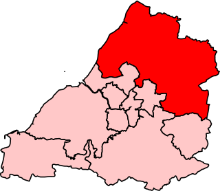
Northavon was, from 1983 until 2010, a constituency represented in the House of Commons of the Parliament of the United Kingdom. It elected one Member of Parliament (MP) by the first past the post system of election.

Frampton on Severn is a village and civil parish in Gloucestershire, England. The population is 1,432.

Pilning railway station is a minor station on the South Wales Main Line near Pilning, South Gloucestershire, England. It is 10 miles (16 km) from Bristol Temple Meads and is the last station on the English side before the Severn Tunnel through to Wales. It is managed by Great Western Railway, who provide the two train services per week from the station.
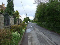
Littleton-upon-Severn is a village and former civil parish, now in the parish of Aust, in the South Gloucestershire district, in the ceremonial county of Gloucestershire, England, near the mouth of the River Severn and is located to the west of Thornbury. Historically it belonged to the Hundred of Langley and Swinehead. In 1931 the parish had a population of 179. On 1 April 1935 the parish was abolished and merged with Aust.

In parts of England and Wales, a rhyne (Somerset), rhine/rhyne (Gloucestershire), or reen is a drainage ditch, or canal, used to turn areas of wetland close to sea level into useful pasture.

Awre is a village, civil parish and electoral ward in the Forest of Dean District of Gloucestershire, England, near the River Severn.
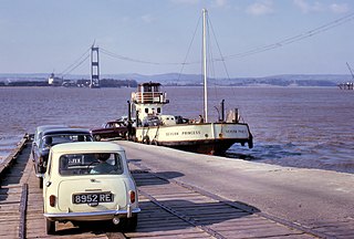
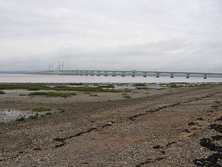
Aust Ferry or Beachley Ferry was a ferry service that operated across the River Severn between Aust and Beachley, both in Gloucestershire, England. Before the Severn Bridge opened in 1966, it provided service for road traffic crossing between the West Country and South Wales. The nearest fixed crossing was a 60-mile (97 km) round trip to Gloucester.

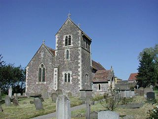
Compton Greenfield is a small hamlet of farms and spread out houses to the south west of Easter Compton, in South Gloucestershire. The parish church of All Saints is a Grade II* listed building. It has a Norman arch in its porch, but the church was largely rebuilt in 1852 in the Neo-Norman style. The churchyard of All Saints is the final resting place of Sir George White founder of the Bristol Aeroplane Company and Sir John Francis Davis, second Governor of Hong Kong.
The BS postcode area, also known as the Bristol postcode area, is a group of 37 postcode districts in South West England, within eight post towns. These cover the city of Bristol, north Somerset and south Gloucestershire.
Northwick is a hamlet in South Gloucestershire, England, first mentioned in 955.

Cross Hands Halt railway station served Pilning, South Gloucestershire, England from 1928 to 1964 on the Severn Beach Line.