Richmond Hill, Leeds

Last updated

Richmond Hill
Richmond Hill Shopping Mart 2 Nov 2016.jpg
Shopping Mart and Church Hall, Upper Accommodation Road
Leeds UK location map.svg
Red pog.svg
Richmond Hill
West Yorkshire UK location map.svg
Red pog.svg
Richmond Hill
Location within West Yorkshire
OS grid reference SE316334
Metropolitan borough
Metropolitan county
Region
Country England
Sovereign state United Kingdom
Post town LEEDS
Postcode district LS9
Dialling code 0113
Police West Yorkshire
Fire West Yorkshire
Ambulance Yorkshire
UK Parliament
List of places
UK
England
Yorkshire
53°47′39″N1°31′32″W / 53.7943°N 1.5256°W / 53.7943; -1.5256

Richmond Hill is a district of Leeds, West Yorkshire, England. The district lies a mile to the east of the city centre between York Road (A64 road), East End Park and Cross Green. The appropriate City of Leeds ward is Burmantofts and Richmond Hill.

Contents

History

Richmond Hill developed as a residential and industrial area during the late-18th and 19th centuries. The housing in the area was originally small cottages, but during the industrial revolution many streets of back-to-back terrace houses were built to house the influx of workers. Upper Accommodation Road is the historic heart of the area with some of the more historic buildings on the west side and newer ones on the east. [1] A Leeds Industrial Co-operative building from 1902 is on a corner with East Park Road. In the 20th century much of the housing stock was updated with schemes such as the Saxton Gardens. The Saxton Gardens estate has since been redeveloped by Urban Splash to create 410 homes, allotments and the largest communal garden in the city. [2]

Four churches were built in the area. On top of the hill is the Anglican Parish Church of St Saviour, a Grade I listed building built in 1845, founded by Edward Bouverie Pusey. [3] Nearby is the redundant Roman Catholic Mount St Mary's Church (opened 1857, closed 1989). It was built to serve the Irish community which had come to live in the area (then slum housing and industry known as The Bank) by the 1850s, and was considered to be the largest parish church in Europe. [4] Mount St Mary's Catholic High School originates from a convent school to serve the same community. [4] On York Road, All Saints Church, (now closed) was built in 1980 to replace an earlier and larger church of the same name. [5] Newbourne Methodist Church, designed by the architects Charlton and Crowther, Leeds, opened in 1971 and is located on Upper Accommodation Road. [6] The church occupies part of the site of the former Bourne Primitive Methodist Chapel, which was opened in 1878. [7]

The former Leeds (Richmond Hill) Circuit of the Methodist Church later became part of the Leeds East Circuit, which merged with Leeds North-East Circuit in September 2013. [8] The circuit's records are now held by the West Yorkshire Archive Service. [9]


Amenities

East Park Medical Centre East Park Medical Centre 5 Nov 2016.jpg
East Park Medical Centre

Richmond Hill has limited amenities. The Electrical Engineering department of the former Leeds College of Technology was at one time based on East Street. There are local shops including off licences, newsagents and fast food takeaways. There is a medical centre and dental practice on East Park Road.

Transport

Richmond Hill lies close to the Leeds Inner Ring Road, and major routes in and out of the city which provides the area with many bus services. Most bus services are operated by First Leeds. The route 4 bus runs to the city centre, Seacroft, Gipton, Harehills, St James' Hospital, Wortley, Bramley and Pudsey. The 19 runs to Garforth, Colton, Halton the city centre, Headingley, West Park, Ireland Wood and Tinshill. The 40 runs to Whinmoor, Swarcliffe, Cross Gates, Halton and the city centre. The 49 runs to Seacroft, Gipton, Harehills, the city centre, Burley, Kirkstall and Bramley. The 50 runs to Seacroft, Oakwood, Harehills, Burley, Kirkstall, Hawksworth and Horsforth. The 56 runs to Whinmoor, Seacroft, Killingbeck, Hyde Park, the University of Leeds, Headingley and Moor Grange. The closest railway station is Leeds railway station, approximately one mile to the west. The railway line runs eastward through the district.

Location grid

See also

Related Research Articles

<span class="mw-page-title-main">Harehills</span> Area of Leeds, West Yorkshire, England

Harehills is an inner-city area of east Leeds, West Yorkshire, England. It is approximately 1 mile (1.6 km) north east of Leeds city centre. Harehills is situated between the A58 and the A64. It sits in the Gipton & Harehills ward of Leeds City Council and the Leeds East parliamentary constituency, between Burmantofts and Gipton, and adjacent to Chapeltown.

<span class="mw-page-title-main">Seacroft</span> Suburb of Leeds, West Yorkshire, England

Seacroft is an outer-city suburb/township consisting mainly of council estate housing covering an extensive area of east Leeds, West Yorkshire, England. It lies in the LS14 Leeds postcode area, around 4 miles (6.4 km) east of Leeds city centre.

<span class="mw-page-title-main">Gipton</span> Human settlement in England

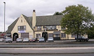
Gipton is a suburb of east Leeds, West Yorkshire, England, between the A58 to the north and the A64 to the south.

<span class="mw-page-title-main">Whinmoor</span> Suburb in England

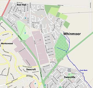
Whinmoor is a residential area of east Leeds, West Yorkshire, England.

<span class="mw-page-title-main">Burmantofts</span> Human settlement in England

Burmantofts is an area of 1960s high-rise housing blocks in inner-city east Leeds, West Yorkshire, England adjacent to the city centre and St. James's Hospital. It is a racially diverse area, with sizable Afro-Caribbean and Irish communities, but suffers the social problems typical of similar areas across the country.

<span class="mw-page-title-main">East End Park, Leeds</span> Area of Leeds, West Yorkshire, England

East End Park is an inner city area of east Leeds, West Yorkshire, England. It is situated between Burmantofts to the north west, Harehills to the north east, Halton Moor to the east, Richmond Hill to the west and Cross Green to the south west. It blends into the Halton Moor/Osmondthorpe area and is 1 mile to the east of Leeds city centre in the LS9 Leeds postcode area.

<span class="mw-page-title-main">Leeds East (UK Parliament constituency)</span> Parliamentary constituency in the United Kingdom

Leeds East is a constituency represented in the House of Commons of the UK Parliament since 2015 by Richard Burgon of the Labour Party.

There are over 3,300 listed buildings in City of Leeds district. Lists of buildings in the upper two categories can be found at Grade I listed buildings in West Yorkshire and Grade II* listed buildings in Leeds.

<span class="mw-page-title-main">Burley, Leeds</span> Area of Leeds, West Yorkshire, England

Burley is an inner city area of Leeds, West Yorkshire, England, 1 mile (1.6 km) north-west of Leeds city centre, between the A65 Kirkstall Road at the south and Headingley at the north, in the Kirkstall ward.

<span class="mw-page-title-main">Swarcliffe</span> Area of the City of Leeds, West Yorkshire, England

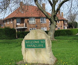
Swarcliffe, originally the Swarcliffe Estate, is a district of Leeds, West Yorkshire, England. It is 4.9 miles (8 km) east of Leeds city centre, and within the LS14 and LS15 Leeds postcode area. The district falls within the Cross Gates and Whinmoor ward of the Leeds Metropolitan Council.

<span class="mw-page-title-main">Wykebeck</span> Suburb of Leeds, West Yorkshire, England

Wykebeck is an area of east Leeds, West Yorkshire, England named after the Wyke Beck and situated between Gipton and Seacroft along Wykebeck Road. The area falls within the Gipton and Harehills ward of the Leeds City Council. The area is seldom referred to, instead people usually perceive Gipton to be West of the beck and Seacroft to be East of it. The area consists of several blocks of highrise council flats to the south.

<span class="mw-page-title-main">Architecture of Leeds</span> Buildings of Leeds, West Yorkshire, England

The architecture of Leeds, a city and metropolitan borough in West Yorkshire, England, encompasses a wide range of architectural styles and notable buildings. As with most northern industrial centres, much of Leeds' prominent architecture is of the Victorian era. However, the City of Leeds also contains buildings from as early as the Middle Ages such as Kirkstall Abbey, one of Britain's best preserved ruined Cistercian monasteries, as well as examples of 20th century industrial architecture, particularly in the districts of Hunslet and Holbeck.

<span class="mw-page-title-main">History of Seacroft</span>

Seacroft pre-dates the Domesday book, with evidence of a settlement in the area from the Neolithic Age. Seacroft remained largely unchanged for centuries as a small Yorkshire village, until in the 1950s the area was developed into Leeds' largest council estate. In the 1960s and 1970s the building of Whinmoor and Swarcliffe enclosed Seacroft within other suburbs.

The Leeds elections were held on 8 May 1970, with one third of the seats up for election, as well as an extra vacancy in Beeston.

The Leeds municipal elections were held on 14 May 1971, with one third of the councillors up for vote including a double vacancy in Talbot.

<span class="mw-page-title-main">1980 Leeds City Council election</span>

The 1980 Leeds City Council election took place on 1 May 1980 to elect members of Leeds City Council in England.

There are a number of listed buildings in West Yorkshire. The term "listed building", in the United Kingdom, refers to a building or structure designated as being of special architectural, historical, or cultural significance. Details of all the listed buildings are contained in the National Heritage List for England. They are categorised in three grades: Grade I consists of buildings of outstanding architectural or historical interest, Grade II* includes significant buildings of more than local interest and Grade II consists of buildings of special architectural or historical interest. Buildings in England are listed by the Secretary of State for Culture, Media and Sport on recommendations provided by English Heritage, which also determines the grading.

References

  1. "Aire Valley Leeds Area Action Plan Local Undesignated Heritage Assets Background Paper" (PDF). www.leeds.gov.uk. Leeds City Council. September 2016. Retrieved 21 July 2017.
  2. "Leodis - a photographic archive of Leeds - Display". Archived from the original on 23 March 2012.
  3. www.leodis.net St Saviour's Church, Ellerby Lane
  4. 1 2 Rosser, Ian (8 December 2005). "Start of a new era". Yorkshire Evening Post. Leeds. ISSN   0963-2255.
  5. www.leodis.net All Saints Church, York Road
  6. Newbourne Methodist Church
  7. Dews, C., Leeds First Circuit; Bourne Chapel, My Primitive Methodists, accessed 6 October 2018
  8. Leeds North and East Circuit, accessed 6 June 2018
  9. National Archives, Richmond Hill Methodist Circuit, Leeds, accessed 6 June 2018