Roaring Fork (Great Smoky Mountains)

Last updated

Roaring Fork Historic District
Roaringfork-gf1.jpg
Roaring Fork, with Grotto Falls in the distance
USA Tennessee location map.svg
Red pog.svg
Usa edcp location map.svg
Red pog.svg
Location GSMNP
Nearest city Gatlinburg, Tennessee
Coordinates 35°41′54″N83°28′4″W / 35.69833°N 83.46778°W / 35.69833; -83.46778
Built1880
NRHP reference No. 76000170 [1]
Added to NRHPMarch 16, 1976

Roaring Fork is a stream in the Great Smoky Mountains of Tennessee, located in the southeastern United States. Once the site of a small Appalachian community, today the stream's area is home to the Roaring Fork Motor Nature Trail and the Roaring Fork Historic District.

Contents

Like many mountain streams, Roaring Fork is volatile. While the stream presents as a peaceful trickle on any given day, it quickly becomes a raging whitewater rapid after a mild rain shower. The "roar" of the water is amplified by its echo on surrounding mountain ridges.

Geography

Sandstone rocks litter the ground at the Jim Bales Place Jimbalesplace2.jpg
Sandstone rocks litter the ground at the Jim Bales Place

The source of Roaring Fork is located nearly 5,000 feet (1,500 m) up along the northern slopes of Mount Le Conte, where several small springs converge. The highest of these springs, known as Basin Spring, provides the water source for LeConte Lodge. [2] From its source, Roaring Fork drops 2,500 feet (760 m) over just two miles (3.2 km), spilling over Grotto Falls and absorbing Surry Creek before steadying in a narrow valley between Mount Winnesoka and Piney Mountain. The mouth of Roaring Fork is located at the northern end of Gatlinburg, where it empties into the West Fork of the Little Pigeon River.

The Roaring Fork valley is underlain by Precambrian sandstone of the Ocoee Supergroup, a rock formation formed from ancient ocean sediments nearly a billion years ago. Roaring Fork Sandstone is found throughout the mid-level elevations of the northern Smokies and is especially common in Greenbrier to the east and the Sugarlands to the west. Over thousands of years, erosional forces have carried boulders composed of this sandstone down from boulder fields located higher up along the mountain ridges. [3] This process has left the streambed of Roaring Fork and the flats in the Roaring Fork valley virtually covered with sandstone rocks of all sizes. Farmers who lived at Roaring Fork, the Sugarlands, and Greenbrier were continually moving and stacking these rocks, creating the characteristic rock walls that still criss-cross these areas today.

Baskins Creek Falls, located along Baskins Creek Trail in the heart of the Roaring Fork area Baskins Creek Falls, November 2012.jpg
Baskins Creek Falls, located along Baskins Creek Trail in the heart of the Roaring Fork area

Roaring Fork Historic District

Alfred Reagan's tub mill Alfredreaganmill1.jpg
Alfred Reagan's tub mill

Between 1800 and 1810, the first permanent Euro-American settlers arrived in the White Oak Flats area around what is now Gatlinburg. In the following decades, their descendants spread out into the surrounding coves and valleys. Richard Reagan (1776–1829), the son of one of these pioneers, settled on a large plot of land just south of Gatlinburg along LeConte Creek. Some of Reagan's children settled to the west in the Sugarlands, while some of them moved east to the hollow along Roaring Fork, which was then known as "Spruce Flats." By 1900, three of Reagan's grandsons, Alfred Reagan (1856–1928), Aaron Reagan, and John H. Reagan were still farming along the stream, just above Gatlinburg. [4]

Jim Bales Place, with barn (right), corn crib (left), and the Alex Cole Cabin (center) Jimbalesplace1.jpg
Jim Bales Place, with barn (right), corn crib (left), and the Alex Cole Cabin (center)

The Bales family settled in the upper section of Roaring Fork sometime in the 1830s or earlier. Caleb Bales (1839–1913), apparently a son or nephew of the first Bales to settle on Roaring Fork, owned a farm just south of the Reagan lands. Caleb's sons Jim Bales (1869–1939) and Ephraim Bales (1867–1936) would spend most of their lives on Roaring Fork farming land inherited from their father. [5]

As the Bales and Reagan families lived on adjoining lands, the families intermarried. Caleb Bales married one of Richard Reagan's granddaughters, Elizabeth, in 1861. Ephraim Bales married a great-granddaughter of Richard Reagan, Minerva, in 1889. Caleb's daughter, Martha, married Alfred Reagan in 1879. [6]

Uppermost on Roaring Fork, near where the stream absorbs Surry Creek, were farms owned by the Clabo family, Gilbert Ogle, and Jasper Mellinger. [5] Former homesteads can usually be identified by the preponderance of young tuliptrees (rather than the more common hemlock or oak), as tuliptrees are the quickest to reclaim previously cultivated land. [7]

Around 1850, the residents of Roaring Fork constructed a crude road connecting the area to White Oak Flats (this old road is now a stop along the Roaring Fork Motor Nature Trail). By 1900, the community had matured into a mountain hamlet with its own school, church, general store, and tub mills. [7] In 1976, the Roaring Fork Historic District was listed on the National Register of Historic Places. [1]

Jim Bales Place

The first historic stop along the Roaring Fork Motor Nature Trail is the Jim Bales Place, a farm which Jim Bales inherited from his father, Caleb. [5] Jim, born James Wesley Bales in 1869, lived here for much of his life. He married Emma Ogle, a granddaughter of Gilbert Ogle, whose farm was located just above the Bales Place. As Bales got older, the farm passed on to other families, one of which erected a modern frame house on the land (known as the "fancy house") where they entertained visitors. [8]

When the Park Service gained control of the land in the 1930s, the frame house was torn down. The Alex Cole Cabin, being more representative of the pioneer days of Appalachia, was moved to the farm from the Sugarlands. [9] Bales' corn crib and barn remain, however.

Ephraim Bales Place

The Ephraim Bales Cabin Ephraimbalescabin2.jpg
The Ephraim Bales Cabin

Just below the Jim Bales place is the farm of Ephraim and Minerva Bales. Ephraim, Jim Bales' older brother, farmed some 30 acres (120,000 m2) of his 70-acre (280,000 m2) plot. The other 40 acres (160,000 m2) were mostly wooded, which the Bales family used for construction material and firewood. [10]

The Bales cabin was a double cabin with a passageway known as a "dog trot" in between. Dog-trot cabins, which are fairly common throughout the southeastern U.S., typically involve two adjacent cabins with roughly 10 feet (3.0 m) in between, but with one continuous roof. The space between the two halves was relatively cool in summer and warm in winter, making it attractive to dogs. Both halves of the cabin have their own chimney. [11]

With the exception of a back porch, the cabin remains largely as it was when the Bales family lived in here in the early 20th century. [10] Along with the cabin, Bales' corn crib, hog pen, and barn are still standing today, just a few yards from the cabin. A rock wall and paling fence behind the cabin are representative of the two major barriers used in the northern Smokies in the late 19th and early 20th centuries.

Alfred Reagan Place

The Alfred Reagan Cabin Alfredreagancabin3.jpg
The Alfred Reagan Cabin

Alfred Reagan, a descendant of the area's first settlers, owned a small farm just below the Ephraim Bales Place. Reagan was a jack-of-all-trades, operating the Roaring Fork community's blacksmith shop, general store, and its most consistent grist mill. Reagan was also a part-time preacher at the Roaring Fork Church, for which he donated the land and helped build. [12]

Of all the buildings on Reagan's farm, only his cabin and mill remain today. With its sawboard paneling and coat of paint, Reagan's cabin stands out among historical structures in the Smokies today. The cabin's design is known as a "saddlebag" design, which involves two cabins constructed around a single chimney. [13] A kitchen area was added later. [14]

The Reagan mill is a standard tub mill, with a flume directing water from Roaring Fork to power a tub-wheel turbine. The turbine turns a grindstone which breaks down corn and wheat into cornmeal and flour. Reagan's mill was well designed and well positioned. It is said that when other mills lacked sufficient water power because of low water levels, Reagan's mill would continue to operate. [15]

Alex Cole Cabin

The Alex Cole Cabin is the last surviving structure from the Sugarlands community proper. Built by mountain guide Albert Alexander Cole, it has been moved from its original site to the Jim Bales Place along the Roaring Fork Motor Nature Trail. [16] [17]

Motor Nature Trail

The Roaring Fork Motor Nature Trail is a narrow one-way road that is open to vehicular traffic (cars and small pickup trucks only) in spring, summer, and fall. Along with the historic district, the road passes by two overlooks and a forest that is representative of mid-level elevations in the Smokies.

The trail begins just past the Rainbow Falls Trailhead on Cherokee Orchard Road and slowly ascends Piney Mountain, topping out at an overlook on the mountain's northern slopes (the overlook's elevation is roughly 3,000 feet/910 meters). Just past the overlook, the road passes numerous large chestnut tree blowdowns. These trees, which often grew to 5–6 feet in diameter, were killed off by a blight in the 1930s.

As the road descends Piney Mountain, it passes a parking lot at the Trillium Gap Trailhead. This hiking trail leads past Grotto Falls and Trillium Gap en route to the summit of Mount Le Conte. Trillium Gap—the gap between Brushy Mountain and the main Le Conte massif—was named by Horace Albright, who observed the trillium-filled area in the 1920s. [18]

Past the Trillium Gap Trailhead, the road enters the upper reaches of the Roaring Fork hollow. Patches of young tuliptrees mark the former location of the Clabo and Ogle farms. Immediately after the road crosses Roaring Fork, the Jim Bales Place is visible on the right (east). The Grapeyard Ridge Trail, which connects Roaring Fork to Greenbrier, begins just behind the barn. Past the Jim Bales Place are the Ephraim Bales Place and Alfred Reagan Place.

The road continues to descend past the historic district, passing along the way a parking lot that allows for a view of Roaring Fork. A thin waterfall known as "The Place of a Thousand Drips" is the last stop along the motor trail before it re-enters Gatlinburg.

See also

Related Research Articles

<span class="mw-page-title-main">Sevier County, Tennessee</span> County in Tennessee, United States

Sevier County is a county of the U.S. state of Tennessee. As of the 2020 census, the population was 98,380. Its county seat and largest city is Sevierville. Sevier County comprises the Sevierville, TN Micropolitan Statistical Area, which is included in the Knoxville-Morristown-Sevierville, TN Combined Statistical Area.

<span class="mw-page-title-main">Gatlinburg, Tennessee</span> City in Tennessee, United States

Gatlinburg is a mountain resort city in Sevier County, Tennessee. It is located 39 miles (63 km) southeast of Knoxville and had a population of 3,944 at the 2010 Census and a U.S. Census population of 3,577 in 2020. It is a popular vacation resort, as it rests on the border of Great Smoky Mountains National Park along U.S. Route 441, which connects to Cherokee, North Carolina, on the southeast side of the national park. Prior to incorporation, the town was known as White Oak Flats, or simply White Oak.

<span class="mw-page-title-main">Pigeon Forge, Tennessee</span> City in Tennessee, United States

Pigeon Forge is a mountain resort city in Sevier County, Tennessee, United States. As of the 2020 census, the city had a total population of 6,343. Situated just 5 miles (8 km) north of Great Smoky Mountains National Park, Pigeon Forge is a tourist destination that caters primarily to Southern culture and country music fans. The city's attractions include Dollywood and Dollywood's Splash Country as well as numerous gift shops, outlet malls, amusement rides, and musical theaters.

<span class="mw-page-title-main">Pittman Center, Tennessee</span> Town in Tennessee, United States

Pittman Center is a town in Sevier County, Tennessee, United States. The population was 454 at the 2020 census and 502 at the 2010 census. The town borders Gatlinburg and the Great Smoky Mountains National Park. U.S. 321 passes through the town.

<span class="mw-page-title-main">Sevierville, Tennessee</span> City in Tennessee, United States

Sevierville is a city in and the county seat of Sevier County, Tennessee, United States, located in eastern Tennessee. The population was 17,889 at the 2020 United States Census.

<span class="mw-page-title-main">Great Smoky Mountains National Park</span> National park in Tennessee and North Carolina

Great Smoky Mountains National Park is an American national park in the southeastern United States, with parts in North Carolina and Tennessee. The park straddles the ridgeline of the Great Smoky Mountains, part of the Blue Ridge Mountains, which are a division of the larger Appalachian Mountain chain. The park contains some of the highest mountains in eastern North America, including Clingmans Dome, Mount Guyot, and Mount Le Conte. The border between the two states runs northeast to southwest through the center of the park. The Appalachian Trail passes through the center of the park on its route from Georgia to Maine. With 14.1 million visitors in 2021, the Great Smoky Mountains National Park is the most visited national park in the United States.

<span class="mw-page-title-main">Great Smoky Mountains</span> American mountain range along North Carolina/Tennessee border

The Great Smoky Mountains are a mountain range rising along the Tennessee–North Carolina border in the southeastern United States. They are a subrange of the Appalachian Mountains and form part of the Blue Ridge Physiographic Province. The range is sometimes called the Smoky Mountains, and the name is commonly shortened to the Smokies. The Smokies are best known as the home of the Great Smoky Mountains National Park, which protects most of the range. The park was established in 1934 and, with over 11 million visits per year, is the most visited national park in the United States.

<span class="mw-page-title-main">Little Pigeon River (Tennessee)</span> River in Tennessee, United States

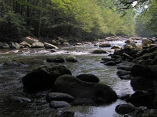
The Little Pigeon River is a river located entirely within Sevier County, Tennessee. It rises from a series of streams which flow together on the dividing ridge between the states of Tennessee and North Carolina, with most of the flow from inside the boundary of the Great Smoky Mountains National Park. The river has three main forks or prongs, East, Middle, and West.

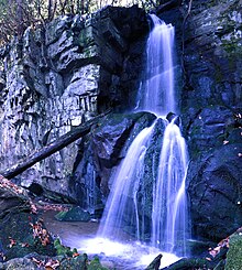
The Trillium Gap Trail is an American hiking trail in the Great Smoky Mountains National Park, in Sevier County, Tennessee. The trail ascends Mount Le Conte, one of the tallest mountains east of the Mississippi River and passes both Grotto Falls and Trillium Gap before reaching the LeConte Lodge, near the summit. The trail to Grotto Falls is one of the busiest in the national park.

<span class="mw-page-title-main">Hiking in the Great Smoky Mountains National Park</span>

The Great Smoky Mountains National Park is a United States National Park located in a region of the Appalachian Mountains referred to as the Great Smoky Mountains, in a portion of east-central Tennessee and southwest North Carolina. With over 150 hiking trails extending for more than 850 miles (1,370 km), within its boundaries, including a seventy-mile segment of the Appalachian Trail, hiking is the most popular activity in the national park.

<span class="mw-page-title-main">The Sugarlands</span> Valley in the north-central Great Smoky Mountains

The Sugarlands is a valley in Tennessee within the north-central Great Smoky Mountains, located in the southeastern United States. Formerly home to a string of small Appalachian communities, the valley is now the location of the Great Smoky Mountains National Park headquarters and the Sugarlands Visitor Center. Lying just south of Gatlinburg, the Sugarlands is one of the park's most popular access points.

<span class="mw-page-title-main">Mount Collins</span> Mountain in North Carolina, USA

Mount Collins is a mountain in the Great Smoky Mountains, located in the Southeastern United States. It has an elevation of 6,188 feet (1,886 m) above sea level. Located along the Appalachian Trail between Clingmans Dome and Newfound Gap, the mountain is a popular destination for thru-hikers. A backcountry shelter and a major trail junction are located along the mountain's northeastern slope. The mountain's summit is located amidst the Southern Appalachian spruce-fir forest that covers much of the upper elevations in the central Smokies.

<span class="mw-page-title-main">Oconaluftee (Great Smoky Mountains)</span> River in North Carolina, USA

The Oconaluftee is the valley of the Oconaluftee River in the Great Smoky Mountains of North Carolina. Formerly the site of a Cherokee village and an Appalachian community, the valley is now North Carolina's main entrance to Great Smoky Mountains National Park.

<span class="mw-page-title-main">Greenbrier (Great Smoky Mountains)</span> Valley in Sevier County, Tennessee

Greenbrier is a valley in the northern Great Smoky Mountains of Tennessee, located in the Southeastern United States. Now a recreational area, Greenbrier was once home to a string of Appalachian communities.

<span class="mw-page-title-main">Sugarland Mountain Trail</span>

The Sugarland Mountain Trail is an American hiking trail, in the Great Smoky Mountains National Park of Sevier County, Tennessee. The trail traverses Sugarland Mountain, a massive ridge running perpendicular to the main crest of the Smokies and effectively dividing the park's north-central section from its northwestern section. Sugarland Mountain is flanked by the deep upper valleys of two of the park's major watersheds— the West Fork of the Little Pigeon River and Little River. The trail passes through several forest types, including deciduous forest at lower elevations, heaths ("hells") along the mountain's backbone formations, and a stand of Southern Appalachian spruce-fir forest in the upper elevations. Occasional breaks in the foliage allow for views of Mount Le Conte and Sevier County to the east and Blanket Mountain and the ridges above Elkmont to the west.

<span class="mw-page-title-main">Noah Ogle Place</span> Historic house in Tennessee, United States

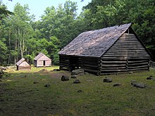
The Noah "Bud" Ogle Place was a homestead located in the Great Smoky Mountains of Sevier County, in the U.S. state of Tennessee. The homestead presently consists of a cabin, barn, and tub mill built by mountain farmer Noah "Bud" Ogle (1863–1913) in the late 19th century. In 1977, the homestead was added to the National Register of Historic Places and is currently maintained by the Great Smoky Mountains National Park.

<span class="mw-page-title-main">Arrowmont School of Arts and Crafts</span> United States historic place

Arrowmont School of Arts and Crafts is an Arts and Crafts center in the U.S. city of Gatlinburg, Tennessee. The oldest craft school in Tennessee, Arrowmont offers workshops in arts and crafts such as painting, woodworking, drawing, glass, photography, basket weaving, ceramics, fiber arts, book arts and metalworking. The School has an 11-month Artists-in-Residence program for early career artists. Arrowmont's campus contains the oldest buildings in Gatlinburg and comprises two historic districts listed on the National Register of Historic Places.

<span class="mw-page-title-main">Walker Sisters Place</span> Historic house in Tennessee, United States

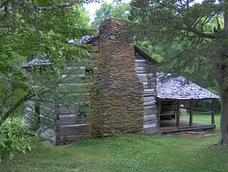
The Walker Sisters Place was a homestead in the Great Smoky Mountains of Sevier County, in the U.S. state of Tennessee. The surviving structures— which include the cabin, springhouse, and corn crib— were once part of a farm that belonged to the Walker Sisters— five spinster sisters who became local legends due to their adherence to traditional ways of living. The sisters inherited the farm from their father, and after the Great Smoky Mountains National Park was formed in the 1930s, they obtained a lifetime lease. The National Park Service gained control of the property in 1964 when the last Walker sister died. The surviving structures were placed on the National Register of Historic Places in 1976.

<span class="mw-page-title-main">Alex Cole Cabin</span> Historic house in Tennessee, United States

The Alex Cole Cabin is a historic house in Sevier County, Tennessee, United States, along Roaring Fork within the Great Smoky Mountains National Park. The last remaining building of the community of Sugarlands, it was built by Albert Alexander "Alex" Cole (1870–1958). The cabin was originally located at 35°40′0″N83°31′17″W, across the Little Pigeon River from what is now the "Quiet Walkway" opposite the Huskey Gap Trailhead, just off Newfound Gap Road. After being placed on the National Register of Historic Places in the 1970s, the cabin was moved to the Jim Bales Place along the Roaring Fork Motor Nature Trail.

References

  1. 1 2 "National Register Information System". National Register of Historic Places . National Park Service. March 13, 2009.
  2. Carson Brewer, Great Smoky Mountains National Park (Portland, Oregon: Graphic Arts Center Publishing, 1993), 11.
  3. Harry Moore, A Roadside Guide to the Geology of the Great Smoky Mountains National Park (Knoxville: University of Tennessee Press, 1988), 29–34, 68.
  4. Jerry Wear, The Sugarlands: A Lost Community in Sevier County, Tennessee (Sevierville, Tennessee: Sevierville Heritage Committee, 1986), map on the last page (not numbered).
  5. 1 2 3 Jerry Wear, Sugarlands: A Lost Community in Sevier County, Tennessee (Sevierville, Tennessee: Sevierville Heritage Committee, 1986), map on the last page (not numbered).
  6. For information on the genealogy of the families of Caleb Bales and Richard Reagan, see their individual entries at http://www.smokykin.com (retrieved: 8 August 2007).
  7. 1 2 Roaring Fork Auto Tour Guide (Gatlinburg: Great Smoky Mountains Association, 1999), 6.
  8. Jerry Wear, Sugarlands: A Lost Community in Sevier County, Tennessee (Sevierville, Tennessee: Sevierville Heritage Committee, 1986), 75-85.
  9. Michal Strutin, History Hikes of the Smokies (Gatlinburg: Great Smoky Mountains Association, 1994), 204.
  10. 1 2 Roaring Fork Auto Tour Guide (Gatlinburg: Great Smoky Mountains Association, 1999), 9.
  11. Ed Trout, Historic Buildings of the Smokies (Gatlinburg: Great Smoky Mountains Association, 1995), 16.
  12. Roaring Fork Auto Tour Guide (Gatlinburg: Great Smoky Mountains Association, 1999), 11-12.
  13. Ed Trout, Historic Buildings of the Smokies (Gatlinburg: Great Smoky Mountains Association, 1995), 16-17.
  14. Roaring Fork Auto Tour Guide (Gatlinburg: Great Smoky Mountains Association, 1999), 13.
  15. Roaring Fork Auto Tour Guide (Gatlinburg: Great Smoky Mountains Association, 1999), 11-13.
  16. Paul Gordon, National Registration of Historic Places Nomination Form for Alex Cole Cabin, 17 April 1974. Retrieved: 2009-09-21.
  17. Wear, 82.
  18. George McCoy, Guide to the Great Smoky Mountains National Park (Asheville: The Inland Press, 1935), 41–42.